SoldIllustrated French map of U.S 1855Title: Nouvelle Carte Illustree de l'Amerique du Nord Indiquant les Grandes Divisions Physiques, la Distribution Geographique des Vegetaux et des Mineraux Author: Vuillemin, Alexandre A. Description:See Sold Price
SoldIllustrated French map of U.S 1855Title: Nouvelle Carte Illustree de l'Amerique du Nord Indiquant les Grandes Divisions Physiques, la Distribution Geographique des Vegetaux et des Mineraux Author: Vuillemin, Alexandre A. Description:See Sold Price
Sold20V James D Richardson A COMPILATION OF THE MESSAGES20V James D Richardson A COMPILATION OF THE MESSAGES AND PAPERS OF THE PRESIDENTS 1897 Complete Set Decorative Leather & Gilt Binding Illustrated Maps US History Inaugural Addresses Proclamations WashSee Sold Price
SoldFrench map of U.S. derived from MelishHeading: Author: Buchon, Jean Alexandre Title: Etats-Unis d'Amerique Place Published: Paris Publisher: Date Published: 1825 Description: Copper-engraved map, hand-colored.See Sold Price
SoldFrench map of U.S. derived from MelishTitle: Etats-Unis d'Amerique Author: Buchon, Jean Alexandre Description: Copper-engraved map, hand-colored. 42x53 cm. (16½x21").The United States derived from John Melish, published in Buchon's AtlasSee Sold Price
18th century French map of U.S.,"Carte des Etats-Unis…M. Brion de la Tour…Paris," undated, probably mid-18th century, eastern coast of United States from Florida to New England, hand-colored features, damage and losses to upperSee Sold Price
SoldColton Wall Map of U.S. 1855Title: Colton's Map of the United States of America, the British Provinces, Mexico and the West Indies, Showing the Country from the Atlantic to the Pacific Ocean Author: Colton, J.H. Description: LitSee Sold Price
French Map of U.S. & Antilles c.1805Title: Etats Unis et Grandes Antilles Author: Chamouin, Jean Baptiste Marie Description: Copper-engraved map, hand-colored in outline. 29.5x22.2 cm. (11½x8½").Early nineteenth century map of the UniSee Sold Price
SoldFrench map of U.S. with independent Texas 1842Title: Carte des Etats-Unis d'Amerique, du Canada, du Nouveau Brunswick et d'une Partie de la Nouvelle Bretagne Author: Lapie, [Pierre & Alexandre Emile] Description: Engraved map, hand-colored. 39.8xSee Sold Price
French map of U.S. derived from MelishTitle: Etats-Unis d'Amerique Author: Buchon, Jean Alexandre Description: Copper-engraved map, hand-colored. 42x53 cm. (16½x21").The United States derived from John Melish, published in Buchon's AtlasSee Sold Price
SoldFrench map of U.S. 1846Title: Carte des Etats-Unis Author: Dussieux, Louis Etienne Description: Engraved map, hand-colored. 28x38 cm. (11x15").The United States just after seizing the Southwest from Mexico and incorporatingSee Sold Price
SoldFrench map of U.S. & Mexico, c.1848Title: États-Unis & Méxique Author: Furne et Cie. Description: Steel-engraved map, hand-colored. 33.5x42 cm. (13¼x16½"), matted.The United States and Mexico just after the war which secured CalifoSee Sold Price
Sold1846 US History & Topography Illustrated Maps Canals US1846 US History & Topography Illustrated Maps Canals US Sea-Ports Botany John Hinton John Howard Hinton was an English author. Among his many other works, he published “The history and Topography ofSee Sold Price
Sold1850 US History & Topography Illustrated Maps Canals US1850 US History & Topography Illustrated Maps Canals US Sea-Ports Botany John Hinton John Howard Hinton was an English author. Among his many other works, he published “The History and Topography ofSee Sold Price
Sold1877 NEW YORK History Illustrated MAPS Steamboats US1877 NEW YORK History Illustrated MAPS Steamboats US Bridges 2v Martha Lamb “…three thousand miles from civilization, becomes within three centuries the seat of the arrogant metropolis of the WestSee Sold Price
3 French maps of U.S. & North AmericaTitle: Lot of three French maps of the United States & North America Author: ** Description: Includes: Migeon. Amerique du Nord. With vignette of New York harbor and the Statue of Liberty. 32x43 cm. 1See Sold Price
Sold1850 1st ed France and Its Revolutions Illustrated1850 1st ed France and Its Revolutions Illustrated French Politics MAP Portraits An incredible 1850 printing of Charles Long’s ‘France and its Revolutions’ – a unique English account of FrenchSee Sold Price
SoldAlfred H Guernsey and Henry M Alden HARPER’SAlfred H Guernsey and Henry M Alden HARPER’S PICTORIAL HISTORY OF THE CIVIL WAR 1866/1868 Complete Set Folio Decorative Leather Gilt Illustrated Maps Battles US History Portraits Title: Harper&See Sold Price
Sold1804 FRENCH MAP OF EASTERN US, TARDIEU.Carte Generale Des Etas Unis, 1804 map of the Eastern portion of the United States of America, engraved by Tardieu. Overall in frame 18.5” x 26”.See Sold Price
SoldFrench Map of Western U.S. c.1870Heading: Author: Andriveau-Goujon Title: Etats-Unis (Etats l'Ouest) Place Published: [Paris] Publisher: Date Published: [c.1870] Description: Engraved map, hand-colored. 62See Sold Price
Sold1855 U.S. MAP BY J.H.COLTON1855 U.S. MAP BY J.H.COLTON: Framed under glass. Sight size 34''h x 42''.See Sold Price
Superb Large Geological Map of U.S. & Canada - 1855Johnston, Alexander K. (1804-1971), & Rogers, Henry. D. (1808-1866). Geological Map of the United States and British North America...Lithographed map. William Blackwood & Sons, 1855. 20" x 24 ¼" shSee Sold Price
French map of present U.S. 1802Title: Louisiane et Pays Voisins, d'apres les Relations et les Cartes les Plus Recentes par L. Collin Author: Collin, L. Description: Copper-engraved map. 24x36 cm. (9½x14").Most of the current UniteSee Sold Price
Wilson - Wood Thrush, Red-breasted Thrush or Robin, & Nuthatches. 2Trillium Antique Prints & Rare Books4.5(30)See Sold PriceFeb 24, 2024
Wilson - Grosbeak, Warbler, Siskin, & Flycatcher. 17Trillium Antique Prints & Rare Books4.5(30)See Sold PriceFeb 24, 2024
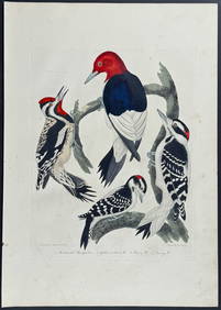
Wilson - Woodpeckers - Red-headed, Yellow-bellied, Hairy, & Downy. 9Trillium Antique Prints & Rare Books4.5(30)See Sold PriceFeb 24, 2024
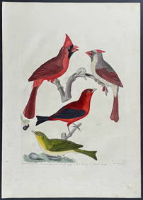
Wilson - Cardinal Grosbeak & Red Tanager. 11Trillium Antique Prints & Rare Books4.5(30)See Sold PriceFeb 24, 2024
Wilson - Mottled Owl, Lark, Creeper, & Warbler. 19Trillium Antique Prints & Rare Books4.5(30)See Sold PriceFeb 24, 2024
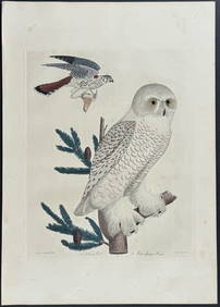
Wilson - Snow Owl (Snowy Owl) & Sparrow Hawk. 32Trillium Antique Prints & Rare Books4.5(30)See Sold PriceFeb 24, 2024
Wilson - Ivory-billed Woodpecker, Red-headed & Pileated Woodpeckers. 29Trillium Antique Prints & Rare Books4.5(30)See Sold PriceFeb 24, 2024
Wilson - Carolina Parrot & Flycatchers. 26Trillium Antique Prints & Rare Books4.5(30)See Sold PriceFeb 24, 2024
1855 NOTES ON CENTRAL AMERICA by E. G. Squier antique w/ MAPSJasper524.5(9.8k)See Sold PriceFeb 27, 2024
1749-1771 HISTORY OF ROMAN EMPERORS 12 VOLUMES antique ILLUSTRATED w/ MAPSJasper524.5(9.8k)See Sold PriceFeb 27, 2024
1790 AFRICA TRAVELS Voyages dans le pays des Hottentots ILLUSTRATED antique RAREJasper524.5(9.8k)See Sold PriceFeb 27, 2024
Map of Part of the West Indies, Etc., Showing the Exact Position Of The U.S. War Steamer SanJasper524.5(9.8k)See Sold PriceFeb 27, 2024
Tour of the Dutch East Indies, with exceptional platesPBA Galleries4.7(381)See Sold PriceMar 07, 2024
1774: AN ANTIQUE ILLUSTRATED TWO-VOLUME HISTORY OF PERUVIAN DISCOVERY AND CONQUEST WITH MAPNY Elizabeth 4.3(84)See Sold PriceMar 03, 2024
1792 OLD INDIA HISTORY ANTIQUE ILLUSTRATED WITH MAPS OF THE EIGHTEENTH CENTURY IN FRENCHNY Elizabeth 4.3(84)See Sold PriceMar 03, 2024