SoldJohnston's Atlas 1844 with 46 double-page mapsTitle: The National Atlas of Historical, Commercial and Political Geography, constructed from the most Recent and Authentic Sources Author: Johnston, Alexander Keith Description: With 46 double-page mSee Sold Price
SoldJohnston's Atlas 1844 with 46 double-page mapsHeading: (Atlas) Author: Johnston, Alexander Keith Title: The National Atlas of Historical, Commercial and Political Geography, constructed from the most Recent and Authentic Sources Place Published:See Sold Price
SoldAtlases.- Johnston (Alexander Keith) The National AtlasAtlases.- Johnston (Alexander Keith) The National Atlas of Historical, Commercial, and Political Geography, engraved title, 46 double-page engraved maps hand-coloured in outline, mounted on stubs, occSee Sold Price
SoldAmerica.- Johnston (Alexander Keith) The National AtlasAmerica.- Johnston (Alexander Keith) The National Atlas of Historical, Commercial, and Political Geography, first edition, engraved title, 46 double-page engraved maps, hand-coloured in wash or outlinSee Sold Price
SoldJohnston's Atlas 1843 with 41 double-page mapsHeading: Author: Johnston, Alexander Keith Title: The National Atlas of Historical, Commercial and Political Geography, constructed from the most Recent and Authentic Sources Place Published: EdinburSee Sold Price
Huge Indian Territory on scarce 1844 map of Western StatesMap of the Southwestern and Part of the Western States from Jesse Olney’s 1844 atlas. Fully hand-colored, double-page map shows all lands west of established states as “Indian Territory.&#See Sold Price
SoldJohnston (Alexander Keith) The Royal AtlasJohnston (Alexander Keith) The Royal Atlas,49 double-page engraved maps, upper hinge broken, contemporary half morocco, gilt, a little rubbed, folio, Edinburgh & London, 1875.See Sold Price
SoldHall (Sidney) A Travelling Atlas of the EnglishHall (Sidney) A Travelling Atlas of the English Counties, 46 wood engraved double page maps, outlined in colour, contemporary half calf, rubbed, 8vo, Chapman & Hall, c.1875.See Sold Price
SoldAtlases.- World.- Teesdale (Henry) [A New General Atlas*** Please note, the description of this lot has changedAtlases.- World.- Teesdale (Henry) [A New General Atlas of the World], lacking title and contents, with 46 double-page maps only, all with fullSee Sold Price
SoldLondon.- Bacon (George W., publisher) Bacon's LargeLondon.- Bacon (George W., publisher) Bacon's Large Scale Atlas of London and Suburbs (revised edition), complete with title, contents, 7 maps of the home counties, and 46 double-page maps including 1See Sold Price
SoldRogers Atlas of the United States 1857Rogers (Henry Darwin) and Alexander Keith Johnston. Atlas of the United States of North America,24 double-page maps, hand-coloured in outline, 9 colour-printed town plans on 5 ff., original haSee Sold Price
SoldMaps: A collection of antique maps and atlasesMaps: A collection of antique maps and atlases including ''A Travelling County Atlas with all the Coach and Rail Roads Accurately Laid Down and Coloured'' containing 46 double page engraved maps by SiSee Sold Price
SoldAtlases.- Johnston (Alexander Keith) The Royal Atlas ofAtlases.- Johnston (Alexander Keith) The Royal Atlas of Modern Geography, 48 double-page maps hand-coloured in outline, with watercourses printed in blue and some inset city plans, mounted on stubs, iSee Sold Price
SoldMaps: A collection of antique maps and atlasesMaps: A collection of antique maps and atlases including ''A Travelling County Atlas with all the Coach and Rail Roads Accurately Laid Down and Coloured'' containing 46 double page engraved maps by SiSee Sold Price
Sold* COLTON, Joseph Hutchins (1800-1893). Colton's Octavo* COLTON, Joseph Hutchins (1800-1893). Colton's Octavo Atlas of the World. New York: G. W. and C. B. Colton & Co., 1866. 8vo (240 x 164 mm). 46 double-page engraved maps with hand-coloring, 1 foldingSee Sold Price
SoldJohnston (Alexander Keith & T.B.) Handy Royal AtlJohnston (Alexander Keith & T.B.) Handy Royal Atlas of Modern Geography,double-page maps coloured in outline, some spotting, broken and loose in binding, original half morocco, rubbed, 4to, 18See Sold Price
Johnston (Alexander Keith) The Royal AtlasJohnston (Alexander Keith) The Royal Atlas,double-page frontispiece and 53 lithographed maps, large repaired tear to world map, a few other small marginal repairs, original half morocco, gilt,See Sold Price
SoldJohnston. The Royal AtlasJohnston (Alexander Keith) The Royal Atlas of Modern Geography,first edition, 48 double-page maps, original outline hand-colouring, watercourses printed in blue, publisher's half morocco, wornSee Sold Price
SoldAtlases.- Johnston (Alexander Keith) The Royal AtlAtlases.- Johnston (Alexander Keith) The Royal Atlas of Modern Geography,48 double-page engraved maps hand-coloured in outline and watercourses printed in blue, map of Africa with overslip ofSee Sold Price
SoldJohnston Physical Atlas of Natural PhenomenaJohnston (Alexander Keith) The Physical Atlas of Natural Phenomena,hand-coloured lithographed double-page frontispiece map and 24 other maps, some foxing, original cloth, gilt, well rebacked iSee Sold Price
Smith (Charles) New English Atlas being a CompleteSmith (Charles) New English Atlas being a Complete Set of County Maps,first edition, engraved title, contents f., 46 hand-coloured double-page maps, modern half calf over contemporary boards,See Sold Price
SoldEngland.- Cary (John) New English Atlas, 1809.England.- Cary (John) New English Atlas, double-page engraved title and 46 double-page hand-coloured engraved county maps on 44 sheets, index leaves at end, printed contents slip pasted to front freeSee Sold Price
SoldTHE PHYSICAL ATLAS OF NATURAL PHENOMENA, 1856.[Atlas]. Alexander Keith Johnston. The Physical Atlas Of Natural Phenomena. W. & A. K. Johnston, 1856. Folio. Half maroon leather, half cloth. 35 double-page maps (varying degrees of color), mostly reSee Sold Price
SoldJohnston (A. K.) The Royal Atlas of Modern GeograJohnston (Alexander Keith) The Royal Atlas of Modern Geography,48 double-page engraved maps with original outline hand-colouring, some browning, dampstaining to preliminaries, publisher's giltSee Sold Price
Rock Island RR Iowa and Minnesota Lakes Country Brochure-1926JM Hobby Supply and Railroad Artifact Auctions4.4(127)See Sold PriceFeb 24, 2024
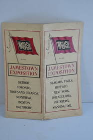
Wabash RR 1907 Jamestown Exposition BrochureJM Hobby Supply and Railroad Artifact Auctions4.4(127)See Sold PriceFeb 24, 2024
Chicago and Northwestern RY April 20, 1906 Public TimetableJM Hobby Supply and Railroad Artifact Auctions4.4(127)See Sold PriceFeb 24, 2024
Chicago Burlington and Quincy RR July 1, 1903 Public TimetableJM Hobby Supply and Railroad Artifact Auctions4.4(127)See Sold PriceFeb 24, 2024
Oxfordshire.- P[lot] (R[obert]) The Natural History of Oxford-shire, being an Essay toward theForum Auctions4.3(53)See Sold PriceFeb 29, 2024
MAGHREB. North Africa Morocco Algeria & Tunisia. JOHNSTON 1913 old antique mapJasper524.5(9.9k)See Sold PriceFeb 28, 2024


![Oxfordshire.- P[lot] (R[obert]) The Natural History of Oxford-shire, being an Essay toward the (1 of 1)](https://p1.liveauctioneers.com/5458/319736/171654562_1_x.jpg?height=282&quality=70&version=1708010439)


