1952 ROBERT F. KENNEDY HANDWRITTEN LETTERJohn McInnis Auctioneers,LLC4.6(504)See Sold PriceFeb 25, 2024
CASED PRESENTATION HALF HULL MODEL OF THE BARQUE "HAWTHORNBANK" Last Quarter of the 19th CenturyEldred's4.7(418)See Sold PriceFeb 27, 2024
Lot Of 14 Jack Daniels And Country Club Glass Spirit BottlesRbfinearts4.4(575)See Sold PriceFeb 24, 2024
PR OF 17TH C. SPANISH BRASS CANDLESTICKSThomaston Place Auction Galleries4.4(389)See Sold PriceFeb 24, 2024
Lake Shore and Michigan Southern RR Special Excursions Timetable-July 7-13, 1892JM Hobby Supply and Railroad Artifact Auctions4.4(126)See Sold PriceFeb 24, 2024
Tiffany & Co. Sterling Silver Corkscrew Bottle OpenerSJ Auctioneers4.5(166)See Sold PriceMar 03, 2024
Sold[TRAVELS] Gibbons, Africa from South to NorthGibbons Alfred, Africa from South to North through Marotseland [...] with numerous illustrations reproduced from photographs, and maps. London: John Lane at The Bodley Head, 1904. In-8° (mm 2See Sold Price
SoldAfrica.- Gibbons (Major A. St. H.) Africa from South toAfrica.- Gibbons (Major A. St. H.) Africa from South to North Through Marotseland, 2 vol., first edition, frontispieces, plates and illustrations, 3 folding maps in pockets at end (2 linen backed), orSee Sold Price
Sold(Major Alfred St.Hill) Africa from South to NorthGibbons (Major Alfred St.Hill) Africa from South to North through Marotseland, 2 vol. in 1, Colonial Edition, photographic illustrations, folding maps, including 2 linen-backed in pocket at eiSee Sold Price
SoldTravels and Discoveries in North and South Africa.Barth, Henry. Travels and Discoveries in North and South Africa. New York: Harper and Brothers, 1857/59. 3 volumes, first American edition, original blue cloth, spine stamped in gilt. 8vo. FrontispiecSee Sold Price
Johnson's Mountains Rivers. Africa, Asia, Europe, South & North America 1861 mapCAPTION PRINTED BELOW PICTURE: 'Mountains & Rivers' DATE PRINTED: 1861 IMAGE SIZE: Approx 44.5 x 64.0cm, 17.5 x 25.25 inches (Large); Please note that this is a folding map. TYPE: Large, decorative haSee Sold Price
Thomson: Antique Map of North & South Africa, 1815Title/Content of Map: North Africa. South Africa. Date Printed: 1815 Cartographer: Size (inches): x20 Drawn and Engraved for Thomson’s New General Atlas Please note that this lot has a confidenSee Sold Price
Sold19th Century English School. "North Africa/ South19th Century English School. "North Africa/ South Africa", Map, Drawn and Engraved for Thomson's New General Atlas 1815, Unframed, 23" x 20.25", and Ten other various Maps, Eleven, (11)See Sold Price
Johnson's Mountains Rivers. Africa, Asia, Europe, South & North America 1866 mapCAPTION PRINTED BELOW PICTURE: 'Johnson's Chart of Comparative Heights of Mountains and Lengths of Rivers of Africa, Asia, Europe, South America, and North America' DATE PRINTED: 1866 IMAGE SIZE: ApprSee Sold Price
Sold1817 North Africa, South Africa by Thomson1817 North Africa, South Africa hand colored map from Thomson's New General Atlas, two sheet, 26" x 21 1/4"See Sold Price
SoldCornwell & Dower 1849 Pair of Miniature Maps of AfricaNorth/South Africa and Africa Physical/Egypt. Steel Engraved Maps Published 1849, London for "A School Atlas" by James Cornwell. Maps by John Dower. Paper Size: 6.5 x 4 inch (16 x 10cm)See Sold Price
SoldGrouping of Early 19th Century MapsGrouping of maps from Thomson's New General Atlas" (1814-1821). Map titles include North Africa/South Africa, South America, Austrian Dominions, Germany, China, Egypt/Abyssinia, Persia, Southern HinduSee Sold Price
Ait Ouaouzguite Flatweave (Fragment)Second half 19th century, 425 x 163 cm, North Africa, South Morocco, Anti-Atlas This large cover (hanbel) woven in a horizontal stripe design in a variety of flatweaving techniques, with brocaded detaSee Sold Price
Cornwell & Dower 1849 Pair of Miniature Maps of AfricaNorth/South Africa and Africa Physical/Egypt. Steel Engraved Maps Published 1849, London for "A School Atlas" by James Cornwell. Maps by John Dower. Paper Size: 6.5 x 4 inch (16 x 10cm)See Sold Price
SoldGROUP FRAMED MAPS INC. NORTH & SOUTH AMERICA, AFRICA &GROUP FRAMED MAPS INC. NORTH & SOUTH AMERICA, AFRICA & HUNGARY 18X16" LARGESTSee Sold Price
Africa, North Part. | Africa, South Part.Title/Content of Map: Africa, North Part. | Africa, South Part. Cartographer: Sidney Hall Date: 1847 Publisher: Adam & Charles Black Size: 15Height - 9.8Width Plate XLIV. Two maps on same sheet; northSee Sold Price
Africa, North Part / Africa, South Part.Title/Content of Map: Africa, North Part / Africa, South Part. Date Printed: 1845 ca. Cartographer: HALL, SIDNEY Size: 7.5x10.25 Two maps on same sheet. Water stained. Please note that this lot has aSee Sold Price
SoldREALISTIC TRAVELS, 105 Stereoviews & Viewer in Fittedstereoviews of scenes from many different countries, including India and the Far East, Africa, North and South America and Europe, in fitted mahogany case with stereoviewer in aluminium with mahoganySee Sold Price
Sold1864 Johnson Chart of Mountains and Rivers perTitle: 1864 Johnson Chart of Mountains and Rivers per Continent -- Johnson's Chart of Comparative Heights of Mountains and Lengths of Rivers of Africa, Asia, Europe, South America and North America CaSee Sold Price
SoldRelief maps of continents with box, c.1880Heading: Author: Ravenstein, August Title: Embossed Atlas for Elementary Instruction in Physical Geography. Containing Maps of Europe, Asia, Africa, North America, South America, Australasia and PolySee Sold Price
SoldSchool Map Case & maps, oak, 7 paper Yaeger maps onSchool Map Case & maps, oak, 7 paper Yaeger maps on wood rollers w/brass pull-down tags for North & South America, Europe, Asia, Africa & others, VG cond w/edge wear on maps, 17.25"H x 46.5"W x 4.75"DSee Sold Price
SoldWORLD POSTCARDS: North America; Tonkin/China; SouthWORLD POSTCARDS: North America; Tonkin/China; South Africa; European; Danish etc. Inspection will reward. 300+ cardsSee Sold Price
Sold"JohnsonLarge, fantastic, collector's book full of (frameable) color and black and white maps and illustrations of North America, South America, Europe, and Africa. Most maps intact and in good condition, a fSee Sold Price
SoldHall, Sidney C1850 Set of 5 Continent MapsEurope, Aisa, Africa, North America, and South America. Steel Engraved Maps Published C1850, London for "A Grammar of General Geography..." by the Rev. J. Goldsmith & Edward Hughes. Folds as issed. MaSee Sold Price
SoldLot of 13: Air France Postcards Airplanes Aviation.Nice artistic images, with one duplicate. Includes North America, South America, Orient and Africa. Aviation advertising. Condition (Very Good - Excellent).See Sold Price
FEDERICO MOLINA ALBERÓ (Barcelona, 1905 - Bunyola, Mallorca, 1981). "Young girl with pitcher". OilSetdart Auction House4(23)See Sold PriceFeb 28, 2024
Natural History - Fossil Dorsal Spine of a SharkTimeLine Auctions Ltd.4.6(182)See Sold PriceMar 08, 2024
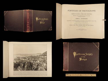
1894 World Photography Travel Cathedrals Paris Opera House Venice Canals IndiansSchilb Antiquarian Rare Books4.8(422)See Sold PriceMar 31, 2024
Carey, pub. 1796 - Map of the Tennassee State formerly part of North Carolina (Tennessee)Trillium Antique Prints & Rare Books4.5(30)See Sold PriceFeb 24, 2024
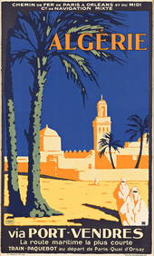
MARC (DATES UNKNOWN) ALGÉRIE / VIA PORT - VENDRES. 1931.Swann Auction Galleries4.4(69)See Sold PriceFeb 29, 2024
AFRICA. French West Africa. Rio de Oro Rio Muni Nigeria. BARTHOLOMEW 1952 mapJasper524.5(9.8k)See Sold PriceFeb 28, 2024
Northern & Southern Africa. Maghreb. Orange River Sovereignty. HALL 1854 mapJasper524.5(9.8k)See Sold PriceFeb 28, 2024
Coste Occidentale d’Afrique…' West Africa. Gulf of Guinea. BELLIN 1746 mapJasper524.5(9.8k)See Sold PriceFeb 28, 2024
NORTH AFRICA. 'Biledulgerid', a former North African country. MALLET 1683 mapJasper524.5(9.8k)See Sold PriceFeb 28, 2024
Northern & Southern Africa. Maghreb. Orange River Sovereignty. HALL 1856 mapJasper524.5(9.8k)See Sold PriceFeb 28, 2024
Coste Orientale d’Afrique…' East Africa Kenya Tanzania Somalia. BELLIN 1746 mapJasper524.5(9.8k)See Sold PriceFeb 28, 2024
Afrique. Pays des Hottentots #51. Botswana South Africa. VANDERMAELEN 1827 mapJasper524.5(9.8k)See Sold PriceFeb 28, 2024
NORTH EAST AFRICA. Libya Egypt Sudan Ethiopia Ubangi-Shari Chad 1952 old mapJasper524.5(9.8k)See Sold PriceFeb 28, 2024
Colonial Africa North-West. British French. Nigeria Sahara. THE TIMES 1900 mapJasper524.5(9.8k)See Sold PriceFeb 28, 2024
Churchill & Nieuhof 1744 Folio Map. Cape of Good Hope, South AfricaAlbion Auctions4.6(341)See Sold PriceMar 01, 2024
Rare Mass Assemblage of Carpoid Fossils - Armored WormsArtemis Fine Arts4.8(1.4k)See Sold PriceMar 01, 2024
![[TRAVELS] Gibbons, Africa from South to North First Image](https://p1.liveauctioneers.com/1306/165899/83732110_1_x.jpg?height=282&quality=95&version=1586937270&width=282)

![[TRAVELS] Gibbons, Africa from South to North First Image](https://p1.liveauctioneers.com/1306/165899/83732110_1_x.jpg?height=282&quality=1&version=1586937270&width=282)


![[TRAVELS] Gibbons, Africa from South to North (1 of 3)](https://p1.liveauctioneers.com/1306/165899/83732110_1_x.jpg?height=282&quality=70&version=1586937270)