SoldVINTAGE MAP OF PACIFIC AREALarge Scale Map of teh Pacific Area Burma and Malaya EAst Indies and the Philippines China and Thailand. "Geographia" MapSee Sold Price
SoldVINTAGE MAP OF PACIFIC AREALarge Scale Map of teh Pacific Area Burma and Malaya EAst Indies and the Philippines China and Thailand. "Geographia" MapSee Sold Price
SoldWWII Philippine Campaign: RESTRICTED Joint IntelWWII Philippine Campaign: RESTRICTED Joint Intelligence Center Pacific Ocean Areas ResSee Sold Price
SoldEarly Boulder City Area Map c1938Early Boulder City Area Map c1938 by Union Pacific Rail-Road in frame - map 30" x 17"See Sold Price
SoldWWII U.S. ARMY AIR FORCE SILK MAPS (3)3 silk maps including 1) Two 1945 34" x 32" maps of Japan and South China one one side and the East China Sea on the reverse, 2) a 1943 36" x 31.5" map of Timor Southwest Pacific area on one side andSee Sold Price
VINTAGE WWII MAP US NAVAL OPERATIONS PACIFIC OCEAN AREAVINTAGE WWII MAP US NAVAL OPERATIONS PACIFIC OCEAN AREA PEARL HARBOR GUADALCANAL VINTAGE WWII MAP US NAVAL OPERATIONS PACIFIC OCEAN AREA PEARL HARBOR GUADALCANAL Description Vintage Map Collage; US NASee Sold Price
Map of the Far East & the Pacific Area 1950'sMap of the Far East and the Pacific Area Including China, Japan and All Pacific Islands. the Item Is in Good Condition. Please note that this lot has a confidential reserve. When you leave a bid in adSee Sold Price
SoldWW2 Survival Escape & Evasion Silk Maps (5)Collection of five silk escape and evasion double sided maps issued to Allied flight crews during World War II. Dimensions and Locations. S.W. Pacific area- 28" x 34". South Borneo- 40" x 34". S. BornSee Sold Price
Art Forms of the Pacific Area.Title: Art Forms of the Pacific Area. Cartographer:COVARRUBIAS, MIGUEL Publisher: SAN FRANCISCO BAY EXPOSITION COMPANY/PACIFIC HOUSE Height: 21 Width: 33.5 "Plate III: Pageant of the Pacific: Miguel CSee Sold Price
Pacific Area in World War II 1941-1945 Wesley SocialPublication Date: 1961 Title: Pacific Area in World War II 1941-1945 Wesley Social Studies [Series] WA34 Cartographer: R. Baxter Blair Publisher: Denoyer-Geppert Co. Height: 28.25 Width: 41.5 Main topSee Sold Price
World War 2. Nov 1943-Dec 1944. Gilbert Islands. Pacific landings & Ops 1959 mapTITLE/CONTENT OF MAP: 'The War with Japan - Landings in the Gilbert Islands, 21 November 1943 and Operations in the Central and Southwest Pacific Areas, January-December 1944' DATE PRINTED: 1959 IMAGESee Sold Price
Pre WWII Lot of 6 Paper National Geographic World MapsLot of 1930s era National Geographic maps in a military envelope to include: Pacific Ocean Area, South America, Central America, Canada, Africa, The World, and an early map of a photo showing a view oSee Sold Price
SoldGeological Map of San Francisco Bay Area, 1853Title/Content of Map: 1853 Geological Map of San Francisco Bay Area for the Pacific Rail Road -- Geological Map of the Vicinity of San Francisco Date Printed: 1853, Philadelphia Cartographer: W BlakeSee Sold Price
Sold''South Pacific,'' Lon: James Imray and Son, 1888[Pacific]. South Pacific. Detailed wall map of an area spanning from the east coast of Australia to the west coast of South America. Lon: James Imray and Son, 1888. 20 3/4 x 51 1/4 inhes, Hundreds ofSee Sold Price
Tallis: Map of Polynesia & Pacific Islands, 1853Polynesia & the Pacific Islands by Tallis, circa 1853. Original lithograph by John Tallis & Company of London, c. 1853. Map features area from California to Japan and features the Society, Friendly, NSee Sold Price
SoldEngraved Map of North America from East to West.[North America] Untitled engraved map of an area from the Atlantic to the Pacific, south to central America. Has a label and city dot for “Winchester,” the name given when the town was incorporateSee Sold Price
SoldThe Camper's Paradise [California] c1909Title: The Camper's Paradise [California] Author: [San Francisco and North Pacific Railway] Description: [12] pp. Photographs views of the area's camping, plus map of the Northern Pacific coast fSee Sold Price
The Camper's Paradise [California] c1909Title: The Camper's Paradise [California] Author: [San Francisco and North Pacific Railway] Description: [12] pp. Photographs views of the area's camping, plus map of the Northern Pacific coast from USee Sold Price
SoldThomson map, United States and Additions, 1820[United States]. J. Thomson. United States And Additions, 1820. Double page engraved map showing the entire area from the Atlantic to the Pacific, including lower Canada and portions of Central AmericSee Sold Price
SoldThomson map, United States and Additions, 1820.[United States]. J. Thomson. United States And Additions, 1820. Double page engraved map showing the entire area from the Atlantic to the Pacific, including lower Canada and portions of Central AmericSee Sold Price
SoldMontana Tourist MemorabiliaThis lot is Montana Tourist Memorabilia. There are 40 Public Lands in Montana maps of different areas, 3 Charles M. Russell National Wilderness Refuge maps, 1 Northern Pacific Yellowstone Park Line brSee Sold Price
1860s Physical map of the United States, J. H. ColtonFascinating early school atlas map identifies the major physical areas of the country (Mississippi Basin, Gulf Slope, Atlantic Slope, Pacific Slope, Great Basin of the Interior, Hudson Bay Basin and LSee Sold Price
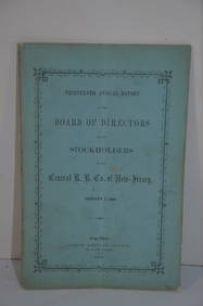
Central Railroad of New Jersey 13th Annual Report-January 1, 1860JM Hobby Supply and Railroad Artifact Auctions4.4(126)See Sold PriceFeb 24, 2024
Northern Pacific RR Washington and Northern Idaho Map Folder-1941JM Hobby Supply and Railroad Artifact Auctions4.4(126)See Sold PriceFeb 24, 2024
Union Pacific RR Map of the United States-1926JM Hobby Supply and Railroad Artifact Auctions4.4(126)See Sold PriceFeb 24, 2024
New York Central RR The Adirondacks Brochure 1916-1917JM Hobby Supply and Railroad Artifact Auctions4.4(126)See Sold PriceFeb 24, 2024
Rock Island RR Iowa and Minnesota Lakes Country Brochure-1926JM Hobby Supply and Railroad Artifact Auctions4.4(126)See Sold PriceFeb 24, 2024
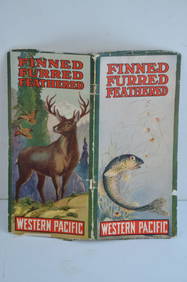
Western Pacific RR Finned Furred Feathered Brochure-1912JM Hobby Supply and Railroad Artifact Auctions4.4(126)See Sold PriceFeb 24, 2024
Map UNITED COUNTIES LEEDS & GRENVILLE by Walling 1861 Rare Canada Map 5ft x 5ftLuis Porretta Fine Arts4.3(10)See Sold PriceMar 02, 2024
1764 Bellin Map of Fort Louis Area of Guadeloupe -- Environs du Fort Louis de la GuadeloupeJasper524.5(9.8k)See Sold PriceFeb 27, 2024
Operation Torch Nov 1942-May 1943. World War 2. Western Mediterranean 1966 mapJasper524.5(9.8k)See Sold PriceFeb 28, 2024
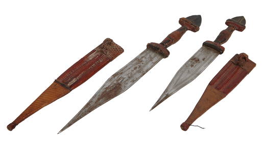
Two Steel Daggers, 20th c., Longer- H.- 12 1/2 in., W.- 1 1/2 in.; Shorter- H.- 10 3/8 in., W.- 1Crescent City Auction Gallery4.3(229)See Sold PriceMar 08, 2024
Blackie (Pub) 1882 Folio Map. West USA - Pacific StatesAlbion Auctions4.6(336)See Sold PriceMar 01, 2024


![The Camper's Paradise [California] c1909 (1 of 2)](https://p1.liveauctioneers.com/642/42407/18551229_1_x.jpg?height=282&quality=70&version=1372186332)
![The Camper's Paradise [California] c1909 (1 of 2)](https://p1.liveauctioneers.com/642/39640/17011648_1_x.jpg?height=282&quality=70&version=1366146381)