Map of Shipwrecks Off the Coast of BermudaMap of Shipwrecks Off the Coast of Bermuda: Location, Ship Name, Dated Wrecked and Cargo. 32" X 42". (100-200)See Sold Price
SoldMap of Shipwrecks Along the Western U.S. Coast1939. Interesting blue map of naval history. Title: Strandings and Wrecks of Vessels on the Coasts of California-Oregon and Washington. Compiled and Traced by Lt. Comdr. W. A. Mason U.S.N., San Pedro,See Sold Price
North America - East Coast Newfoundland to Bermuda.Title/Content of Map: North America - East Coast Newfoundland to Bermuda. Date Printed: 3/1/1975 Cartographer: HYDROGRAPHIC OFFICE. ROYAL NAVY Size: 26X39 "including the Gulf of St. Lawrence and portiSee Sold Price
North America - East Coast Newfoundland to Bermuda.Title: North America - East Coast Newfoundland to Bermuda. Publication Date: 3/1/1975 Cartographer: HYDROGRAPHIC OFFICE. ROYAL NAVY Publisher: ROYAL NAVY. HYDROGRAHIC OFFICE Size: 26Height - 39Width iSee Sold Price
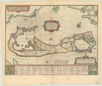
SoldBlaeu (Willem) - Mappa Æstivarum Insularum, aliasBermuda", showing the coasts of Florida, Virginia, Cape Cod and New England, based on Speed's map, large decorative title cartouche, upper centre, compass rose, key below, engraved map with hand-colouSee Sold Price
Sold[MAP OF BERMUDA] BLAEU, WILLEM (c. 1630)Mappa Aestivarum Insularum, alias Barmudas..., engraved bi-fold map with hand-coloring, showing the coasts of Florida, Viginia, Cape Cod, and New England, based on Speed's map, with latin text on versSee Sold Price
Sold1787 HAND COLORED LES ISLES ANTILLESAntique 1787 Hand Colored Map - Les Isles Antilles et le Golfe Du Mexique [Bermuda Inset] By Rigobert Bonne. Detailed map of the Caribbean, Florida, Gulf Coast and Central America, showing islands, cuSee Sold Price
SoldN AMERICA E COAST Canada Virginia New Amsterdam (NewTITLE OF THE MAP: 'Canada ou Nouvelle France' Small vignette. The map runs inland to Lake Superior. Includes Bermuda. Date: 1683 IMAGE SIZE: Approx Overall page size 13 x 21cm approximately (5 x 8 incSee Sold Price
SoldN AMERICA E COAST Canada Virginia New Amsterdam (NewTITLE OF THE MAP: 'Canada ou Nouvelle France' Small vignette. The map runs inland to Lake Superior. Includes Bermuda. DATE PRINTED: 1683 IMAGE SIZE: Approx Overall page size 13 x 21cm approximately (5See Sold Price
N AMERICA E COAST Canada Virginia New Amsterdam (NewTITLE OF THE MAP: 'Canada ou Nouvelle France' Small vignette. The map runs inland to Lake Superior. Includes Bermuda. The top image on the right hand side shows the entire map. To view a close up of tSee Sold Price
Sold18th c. Hand Colored Map of Bermuda and St Kittsan original map by cartographer Emanuel Bowen 1694?-1767, detailed maps of Bermuda and St. Kitts c. 1744, with annotations noting shipwrecks, whaling, fortifications, churches etc. framed 17x19 LitchfSee Sold Price
SoldMap of Bermuda, by Hondius 1633Map of Bermuda, by Hondius 1633. Original hand colored copper engraving. Showing the "tribes" that were granted by the gentleman onboard the shipwreck that force the European settlement of the island.See Sold Price
SoldJansson (Jan) Map of BermudaJansson (Jan) Map of Bermudalarge scale map of Bermuda superimposed on the Gulf of Mexico, also showing the island to scale, just above, with the coasts of Florida, Virginia and New England, wSee Sold Price
Sold[MAPS] Four Facsimiles of Historic Maps[MAPS] Four Facsimiles of Historic Maps of Bermuda, Chile, Venezuela, and part of the Brazilian Coast. Partly colored. 17 1/4 x 19 1/4, uniformly framedSee Sold Price
SoldSix Books: Exploration/TravelA lot of six books: "Handbook of Alaska"; "Other Worlds Than Ours" (1873); "The Arcturus Adventure"; "Along the Labrador Coast"; "Royal Palaces and Parks of France"; The Bermuda Islands".See Sold Price
West Indies - 1856 Colton Atlas of the WorldGreat hand colored map showing Cuba, Dominican Republic, Jamaica, Puerto Rico and the coasts of North America and South America. Excellent condition with no faults. Insets of The Bermuda Islands and CSee Sold Price
SoldJansson (Jan) Mappa Aestivarum Insularum, alias BaJansson (Jan) Mappa Aestivarum Insularum, alias Barmudas Dictarum,large scale map of Bermuda superimposed on the Gulf of Mexico, also showing the island to scale, just above, with the coasts oSee Sold Price
Jansson (Jan) Mappa Aestivarum Insularum, alias BaJansson (Jan) Mappa Aestivarum Insularum, alias Barmudas Dictarum,large scale map of Bermuda superimposed on the Gulf of Mexico, also showing the island to scale, just above, with the coasts oSee Sold Price
Sold[Map] Coast of Georgia, S.C., Florida, SavannahHughes, Andrew. "A Draught of South Carolina and Georgia from Sewee to St. Estaca." London: W. Mount and T. Page, [1778.] Measured from neatlines 32.25" x 18". Professionally mounted at points to acidSee Sold Price
SoldCirca 1730 Framed Map Bermuda & TribesA map of the island of Bermuda "The Island of Bermudo's divided into itsTribes, with the Castles, Forts,...", by H. Moll Geographer, circa 1730, framed, provenance: Estate of F. C. Morgan, 8 3/4 x 11See Sold Price
1757 Bellin Map Coast of BrazilA map of Jacques Bellin printed circa 1757 entitled "Suite du Bresil Depuis la Baye de Tour Saints Jusqu a St. Paul..". Printed at Paris. Very Good, Some mild wear. Measures 7 x 10.5". Reserve: $20.00See Sold Price
SoldEngraved map Coast Survey San FranciscoUnframed engraved map, City Of San Francisco And Its Vicinity, California. United States Coast Survey, 1853, topography by A.F. Rodgers, sheet: 33''H x 25''WSee Sold Price
Sold1862 Civil War map Coast of South Carolina1862 Civil War map Coast of South Carolina. 1862 map Coast of South Carolina from Charleston to Hilton Head. Insets: Plan and view of Fort ~Beauregard~ Bay Point, S.C. Fort on Fenwicks Island,See Sold Price
Sold1862 Civil War map Coast of South Carolina1862 Civil War map Coast of South Carolina. 1862 map Coast of South Carolina from Charleston to Hilton Head. Insets: Plan and view of Fort Beauregard Bay Point, S.C. Fort on Fenwicks Island, SSee Sold Price
RARE 1638 HONDIUS MAP OF BERMUDA, FRAMEDThomaston Place Auction Galleries4.4(386)See Sold PriceFeb 24, 2024
1750 Bowen Map of Bermuda and St. Kitts -- A New & Accurate Map of Bermudas or Sommer's Islands...Jasper524.5(9.8k)See Sold PriceFeb 27, 2024
WEST AFRICA. British Cameroons & Togoland mandates. Gold Coast Nigeria 1947 mapJasper524.5(9.8k)See Sold PriceFeb 28, 2024
Coast & Islands between Cape Roxo. Guinea-Bissau & Bissagos. KITCHIN 1745 mapJasper524.5(9.8k)See Sold PriceFeb 28, 2024
Côte occidentale de l'Afrique. W Africa.Senegal Gambia rivers.D’ANVILLE 1751 mapJasper524.5(9.8k)See Sold PriceFeb 28, 2024
WEST AFRICA I Explorers' routes Senegal Ashanti Ivory Gold Coast. SDUK 1851 mapJasper524.5(9.8k)See Sold PriceFeb 28, 2024
Gulf of Guinea. Ghana Togo Benin Nigeria. ADMIRALTY sea chart 1928 (1954) mapJasper524.5(9.8k)See Sold PriceFeb 28, 2024
Partie de la Coste de Guinée' Sierra Leone Liberia coast BELLIN/SCHLEY 1747 mapJasper524.5(9.8k)See Sold PriceFeb 28, 2024
South Namibia coast. Walvis Bay-Orange River ADMIRALTY sea chart 1881 (1954) mapJasper524.5(9.8k)See Sold PriceFeb 28, 2024
Partie de la Coste de Guinée'. Sierra Leone & Liberia coast. BELLIN 1747 mapJasper524.5(9.8k)See Sold PriceFeb 28, 2024
Suite de la Coste de Guinée'. Ghana Togo Benin coast. BELLIN/SCHLEY 1748 mapJasper524.5(9.8k)See Sold PriceFeb 28, 2024
Partie Occidentale de l'Ancien Continent… W Africa Macaronesia. BONNE 1780 mapJasper524.5(9.8k)See Sold PriceFeb 28, 2024
Coste Occidentale d’Afrique…' Namibia South Africa Angola coast BELLIN 1746 mapJasper524.5(9.8k)See Sold PriceFeb 28, 2024
L'Afrique Françoise ou du Senegal'. French West Africa. DE L’ISLE 1727 mapJasper524.5(9.8k)See Sold PriceFeb 28, 2024
SIX DAYS IN 1866: THE COMPLETE STORY OF THE GREATEST LOSS OF AN ANTIQUE BRITISH SHIPWRECKNY Elizabeth 4.3(84)See Sold PriceMar 03, 2024
Antique Map - Views on the coast of Asia. J. Webber del. Engraved after J. Webber and W. Bligh.Proverde Auctions4.3(3)See Sold PriceFeb 28, 2024


![[MAP OF BERMUDA] BLAEU, WILLEM (c. 1630) (1 of 9)](https://p1.liveauctioneers.com/522/152734/77123885_1_x.jpg?height=282&quality=70&version=1571345617)


![[MAPS] Four Facsimiles of Historic Maps (1 of 1)](https://p1.liveauctioneers.com/292/2698/1164836_1_x.jpg?height=282&quality=70)


![[Map] Coast of Georgia, S.C., Florida, Savannah (1 of 9)](https://p1.liveauctioneers.com/3532/146911/74242108_1_x.jpg?height=282&quality=70&version=1564368564)