SoldTravels Through Sicily & The Lipari Islands, 1827DESCRIPTION: "Travels through Sicily and the Lipari Islands, in the Month of December, 1824". By Captain Edward Bold, a Naval Officer. Illustrated by L. Haghe. Printed for T. Flint. London, 1827. 367See Sold Price
Travels Through Sicily & The Lipari Islands, 1827DESCRIPTION: "Travels through Sicily and the Lipari Islands, in the Month of December, 1824". By Captain Edward Bold, a Naval Officer. Illustrated by L. Haghe. Printed for T. Flint. London, 1827. 367See Sold Price
Isle De Sicile Sicily Map, Mallet, 1683TITLE OF THE MAP: 'Isle de Sicile' Also shows the Aeolian Islands of Ustica Volcano (Vulcano) Alteur Lipari Stromboli & Panaria (Panarea) DATE PRINTED: 1683 IMAGE SIZE: Approx Overall page size 13 x 2See Sold Price
SoldCOCKBURN, LT. GEN. GEORGE. A Voyage to Cadiz and GibCOCKBURN, LT. GEN. GEORGE A Voyage to Cadiz and Gibralter, Up the Mediterranean to Sicily and Malta in 1810 & 1811. Including a description of Sicily and Lipari Islands, and an Excursion in Portugal.See Sold Price
Sold19th Century Italian School "The Aeolian Islands19th Century Italian School "The Aeolian Islands off North of Sicily, also known as "The Lipari Islands," a set of 4 Views depicting large Cathedrals, squares and promenades, 4 1/2" x 6 1/2" (11.5cmsSee Sold Price
Regni & Insulae Sicily Islands Map, Homann, 1747The Contado (Contea) di Modica, or county of Modica is shown in red. The Aeolian Islands are marked at the top of the map The top image on the right hand side shows the entire map. To view a close upSee Sold Price
SoldMap of Sicily Islands 1814Engraving, Map by John Pinkerton, 1814. Map features just islands but was part of a four panel map grid. Dimensions: 11 1/4" x 14 1/4" Please note that this lot has a confidential reserve. When you leSee Sold Price
Carey & Lea: Antique Map of the Leeward Islands, 1827Map: Geographical, Statistical, and Historical Map of the Leeward Islands. Publication Date: 1827 Authors: CAREY & LEA, YEAGER, J. Publisher: CAREY & LEA Size: Quarto – 12.00 H x 9.50 W Inches Map oSee Sold Price
Vandermaelen: Antique Map of Balearic islands, 1827TITLE/CONTENT OF MAP: 'Europe - Iles Baléares et Sardaigne - No 25 ' Part of the western Mediterranean including Sardinia, the Balearic islands, the coasts of Catalonia (including Barcelona), AlgeriaSee Sold Price
SoldBooks Western Europe - Lonely Planet and Other TravelPublished late 20th century AD. Group of current or nearly so editions of travel guides for: Channel Islands, Liverpool, Sicily, Sweden, Venice, Rome, Lisbon, Greece, Berlin Arkitektur, Western EuropeSee Sold Price
SoldBooks Western Europe - Lonely Planet and Other TravelPublished late 20th century AD. Group of current or nearly so editions of travel guides for: Channel Islands, Liverpool, Sicily, Sweden, Venice, Rome, Lisbon, Greece, Berlin Arkitektur, Western EuropeSee Sold Price
SoldWestern Europe - Lonely Planet and Other Travel GuidesPublished late 20th century AD. Group of current or nearly so editions of travel guides for: Channel Islands, Liverpool, Sicily, Sweden, Venice, Rome, Lisbon, Greece, Berlin Arkitektur, Western EuropeSee Sold Price
Books Western Europe - Lonely Planet and Other TravelPublished late 20th century AD. Group of current or nearly so editions of travel guides for: Channel Islands, Liverpool, Sicily, Sweden, Venice, Rome, Lisbon, Greece, Berlin Arkitektur, Western EuropeSee Sold Price
SoldBooks Western Europe - Lonely Planet and Other TravelPublished late 20th century AD. Group of current or nearly so editions of travel guides for: Channel Islands, Liverpool, Sicily, Sweden, Venice, Rome, Lisbon, Greece, Berlin Arkitektur, Western EuropeSee Sold Price
SoldBooks Western Europe - Lonely Planet and Other TravelPublished late 20th century AD. Group of current or nearly so editions of travel guides for: Channel Islands, Liverpool, Sicily, Sweden, Venice, Rome, Lisbon, Greece, Berlin Arkitektur, Western EuropeSee Sold Price
SoldBooks Western Europe - Lonely Planet and Other TravelPublished late 20th century AD. Group of current or nearly so editions of travel guides for: Channel Islands, Liverpool, Sicily, Sweden, Venice, Rome, Lisbon, Greece, Berlin Arkitektur, Western EuropeSee Sold Price
Books Western Europe - Lonely Planet and Other TravelPublished late 20th century AD. Group of current or nearly so editions of travel guides for: Channel Islands, Liverpool, Sicily, Sweden, Venice, Rome, Lisbon, Greece, Berlin Arkitektur, Western EuropeSee Sold Price
Amér Sep Porto Rico #69 Puerto Rico & Virgin Islands VANDERMAELEN 1827 old mapTITLE/CONTENT OF MAP: 'Amér. Sep. - Porto Rico - No. 69' The map shows Puerto Rico, the British Virgin Islands, the US Virgin islands except for Saint Croix, and Anguilla. Inset is a large profilSee Sold Price
Amér. Sep. Ile de Cuba #67. Cuba & Jamaica Cayman Islands. VANDERMAELEN 1827 mapTITLE/CONTENT OF MAP: Amér. Sep. - Ile de Cuba [Ile de Cuba] - No. 67 The map covers most of Cuba and Jamaica, and the Cayman Islands. Inset is a description of the island of Cuba DATE PRINTED: 1See Sold Price
SoldHomann: Antique Map of Sicily Kingdom/Islands, 1747Title/Content of Map: Regni & insulae Siciliae'. Sicily kingdom/islands. Isole Eolie. The Contado (Contea) di Modica, or county of Modica is shown in red. The Aeolian Islands are marked at the top ofSee Sold Price
Regni & insulae Siciliae'. Sicily kingdom/islands.Title/Content of Map: Regni & insulae Siciliae'. Sicily kingdom/islands. Isole Eolie. The Contado (Contea) di Modica, or county of Modica is shown in red. The Aeolian Islands are marked at the top ofSee Sold Price
Homann: Sicily, Sardinia, Maltese IslandsReserve Reduced! Map Title: Regnorum Siciliae et Sardiniae nec non Melitae, seu Maltae, Insulae Cartographer: J. B. Homann Place / Date: Nurnberg / 1720 Size: 22 3/4" x 19 1/4" Condition: old color onSee Sold Price
1827 Cuvier Animal Kingdom Illustrated Fossils Natural History Color PLATES ZoologySchilb Antiquarian Rare Books4.8(421)See Sold PriceMar 10, 2024
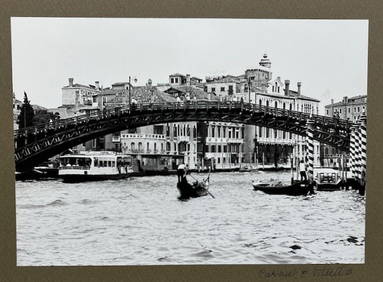
Vintage photograph of Venice by Renowned American Woman PhotographerBert Gallery Studio Sales4.4(18)See Sold PriceFeb 27, 2024
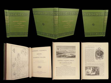
1874 HAWAII 1ed Northern California Oregon Pacific Island Travel Puget RedwoodsSchilb Antiquarian Rare Books4.8(421)See Sold PriceMar 10, 2024
WASHINGTON, JACKSON and other HISTORICAL AMERICANAJohn McInnis Auctioneers,LLC4.6(502)See Sold PriceFeb 24, 2024
Crouching Deity Figure, Caroline Islands, Micronesia, Mid-20th C.Material Culture4.6(765)See Sold PriceFeb 29, 2024
Robert Louis Stevenson - 12 Volumes 1896-1899North American Artifact Auctions4.6(182)See Sold PriceApr 20, 2024
Light Blue Sunset In Salina Eau De Toilette Spray By Dolce & GabbanaBidhaus4.3(747)See Sold PriceFeb 27, 2024
West Indies Windward Lesser Antilles. Martinique (Belonging to France)Jasper524.5(9.8k)See Sold PriceFeb 27, 2024
Churchill & Nieuhof 1744 Map. Batavia Jakarta IndonesiaAlbion Auctions4.6(336)See Sold PriceMar 01, 2024