Later Maps of North America Later Maps of North America Lot of 7. Bradford, T.G. North Carolina, South Carolina, and Georgia. From a Comprehensive Atlas: Geographical, Historical and Commercial, 1835; outline color, some stainSee Sold Price
SoldMap of North America c.1750Title: North America Author: Jefferys, Thomas Description: Copper-engraved map, hand-colored (later). 18x23 cm. (7x9").Little map of North America with pictorial cartouche featuring Native Americans iSee Sold Price
Darton map of North America 1820Title: North America from the Latest Authorities Author: Darton, William Description: Copper-engraved map, hand-colored (later). 23x27 cm. (9x10½").Unusual map of North America in which Mexico controSee Sold Price
NORTH AMERICA. State borders differ from those laterTITLE/CONTENT OF MAP: 'North America' DATE PRINTED: 1862 IMAGE SIZE: Approx 65.0 x 45.5cm, 25.5 x 17.75 inches (Large); Please note that this is a folding map. TYPE: Antique map with original outlineSee Sold Price
Ettling: Antique Map of North America, 1862TITLE/CONTENT OF MAP: 'North America' State borders differ from those later settled. DATE PRINTED: 1862 IMAGE SIZE: Approx 65.0 x 45.5cm, 25.5 x 17.75 inches (Large); Please note that this is a foldinSee Sold Price
SoldBlaeu Engraved Map of North AmericaAmericae Nova Tabula. Willem Blaeu (1571-1638). Engraved map with original hand color. Amsterdam, c. 1645 or later (state 5). 17 x 22 3/4 inches visible, 27 x 33 inches framed. This is one of the fewSee Sold Price
SoldRARE EARLY MAP OF NORTH AMERICA - Matthias Seutter,RARE EARLY MAP OF NORTH AMERICA - Matthias Seutter, copperplate engraving on laid paper, with later hand coloring, circa 1730; "Recens Edita Totius novi Belgii in America Septentrionali siti DelineatoSee Sold Price
SoldNorth America prior to RevolutionTitle: North America Drawn from the Latest & Best Authorities Author: Kitchin, Thomas Description: Copper-engraved map, later hand-coloring in outline. 34x36 cm. (13½x14").Attractive map of North AmeSee Sold Price
SoldMap of North America c.1780Heading: (North America Author: Bonne, Rigobert Title: Amérique Septentrionale Place Published: Paris Publisher: Date Published: c.1780 Description: Copper-engraved map, hanSee Sold Price
Sold19th Century map of North America printed onto clo19th Century map of North America printed onto cloth and stamped R. Gray, Glasgow 1811, in a later frame, 53cm x 61cmSee Sold Price
SoldMallet's North America California an islandTitle: Amerique Septentrionale Author: Mallet, Alain Manesson Description: Copper-engraved map, later hand-coloring. 15x11.5 cm. (6x4½").Charming miniature map of the continent with the island of CalSee Sold Price
British and French Settlements in North AmericaTitle: A Map of the British and French Settlements in North America Author: Gentleman's Magazine Description: Copper-engraved map, later hand-coloring in outline, colored decorative cartouche. 28x39.2See Sold Price
SoldNorth America prior to RevolutionTitle: North America Drawn from the Latest & Best Authorities Author: Kitchin, Thomas Description: Copper-engraved map, later hand-coloring in outline. 34x36 cm. (13½x14").Attractive map of North AmeSee Sold Price
Sanson map of North America California an IslandTitle: Americque Septentrionale Author: Sanson, Nicolas Description: Copper-engraved map, hand-colored in outline (possibly later). Engraved by A. Peyrounin. 19.7x27.5 cm. (7¾x10¾").North America, wSee Sold Price
Chatelain map of North America 1705 hand-coloredTitle: Nouvelle Carte de l'Amerique Septentrionale Dressee sur les Plus Nouvelles Observation... Author: Chatelain, Henri Abraham Description: Copper-engraved map, later hand-coloring. 47x59.4 cm. (18See Sold Price
SoldChatelain map of North America 1705 hand-coloredTitle: Nouvelle Carte de l'Amerique Septentrionale Dressee sur les Plus Nouvelles Observation... Author: Chatelain, Henri Abraham Description: Copper-engraved map, later hand-coloring. 47x59.4 cm. (18See Sold Price
Mallet's North America California an islandTitle: Amerique Septentrionale Author: Mallet, Alain Manesson Description: Copper-engraved map, later hand-coloring. 15x11.5 cm. (6x4½").Charming miniature map of the continent with the island of CalSee Sold Price
Map of North America c.1795Title: A General Map of North America from the Best Authorities Author: Guthrie, William Description: Copper-engraved map, hand-colored (later). Engraved by Russell. 18x23 cm. (7x9").From Guthrie's GeSee Sold Price
SoldSanson map of North America California an IslandTitle: America Settentrional di N. Sanson di Abbeville ... Author: Sanson, Nicolas Description: Copper-engraved map, later hand-coloring. 14.5x16 cm. (5¾x6¼"), corner mounted & framed under plexiglaSee Sold Price
Sanson's map of North America, Calif. an islandTitle: Amerique Septentrionale Author: Sanson, Guillaume Description: Copper-engraved map, hand-colored in outline (later); colored cartouche. 39.8x55.8 cm. (15¾x22").Guillaume Sanson's new map of NoSee Sold Price
SoldHinton map of North America, 1832, framedHeading: Author: Hinton, John Howard Title: North America Place Published: [London] Publisher:Hinton, Simpkin & Marshall Date Published: 1832 Description: Engraved map, hanSee Sold Price
SoldMAP - ARROWSMITH. Chart of the West Indies.MAP - ARROWSMITH, Aaron. Chart of the West Indies and Spanish Dominions in North America.London: Arrowsmith, 1810 or later. Engraved map on four sheets, joined to two, hand-colored in outlineSee Sold Price
Sold(Maps and Charts, North America), Blaeu, Willem (1(Maps and Charts, North America), Blaeu, Willem (1571-1638), Nova Virginia tabula, [Amsterdam, 1660 or later], hand-colored, double-page folio, text verso, unframed, sheet size 23 1/8 x 19 in., (minorSee Sold Price
Sold(Maps and Charts, North America, Virginia), de Bry(Maps and Charts, North America, Virginia), de Bry, Theodor, after White, John, Americae pars, Nunc Virginia dicta..., [Frankfort, 1590 or later], 420 x 305 mm, (hinged to mat, scattered light soilingSee Sold Price
5 Dollars - Elizabeth II Map of North AmericaWeatherham Estate Treasures3.9(157)See Sold PriceMar 07, 2024
Arrowsmith & Lewis - Map of North AmericaTrillium Antique Prints & Rare Books4.5(30)See Sold PriceFeb 24, 2024
Map: An 18thC engraved and hand coloured map of North America and South America, titled DeClaydon Auctioneers Ltd4.3(125)See Sold PriceFeb 26, 2024
1822 MAP of NORTH & SOUTH AMERICA GEOGRAPHICAL STATISTICAL HISTORICAL antiqueJasper524.5(9.8k)See Sold PriceFeb 27, 2024
New and Correct Map of North America With the West India Islands,Jasper524.5(9.8k)See Sold PriceFeb 27, 2024
First 50 plates from Audubon's Quad Quarto (all in Vol. I)PBA Galleries4.7(383)See Sold PriceMar 07, 2024
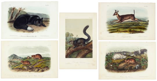
Nearly complete set of plates from Vol. III Quad QuartoPBA Galleries4.7(383)See Sold PriceMar 07, 2024
Italian edition of Sanson's map of North America, 1677PBA Galleries4.7(383)See Sold PriceMar 07, 2024
Blackie (Pub) 1882 Folio Map. United States of North AmericaAlbion Auctions4.6(341)See Sold PriceMar 01, 2024