Sold1886 Map of Indian NationsAuthor: Clare Title: 1886 Map of Indian Nations Medium: Ink on Paper Dimensions: 14.5"X11" Description: Map dated 1886 part of Watson's General Atlast. Engraved by I.S. Clare it captures the Indian NaSee Sold Price
SoldEssex Co. NJ Map Book of Maplewood and OrangesVintage Essex co. NJ Vol. 4 . Losses.See Sold Price
SoldWhitehouse Annandale NJ & Misc Half Pint Milk BottlesIn this lot is Durling Farms Whitehouse, International Irvington, Annandale Creamery , Sheffield , & MiscSee Sold Price
Sold1886 Map of CharlestonAuthor: Cram Title: 1886 Map of Charleston Medium: Ink on Paper Dimensions: 11"X14.5" Map of Charleston dated 1886. Engraved and printed by George Cram in Chicago. Out of all the city maps, CharlestonSee Sold Price
Sold1886 Map of MontanaAuthor: Cram Title: 1886 Map of Montana Medium: Ink on Paper Dimensions: 21"X13.5" Map of Montana dated 1886. Printed and published by George Cram in Chicago. Part of his World Atlas. Key lower left.See Sold Price
Sold1886 Map of the Chinese EmpireAuthor: Blackie Title: 1886 Map of the Chinese Empire Materials: Ink on Paper Size/Dimensions: 21"X15" Description: Map of the Chinese Empire dated 1886. Part of the Imperial Atlas of Modern GeographySee Sold Price
SoldTEXAS C. 1886 MAP, PART OF INDIAN TERRITORYFramed map of Texas, c. 1886, showing counties with an inset for the Panhandle and a portion of the Indian Territory (Cheyennes, Arrapahoes), sight: 11.75"h, 17"w, overall: 21.75"h, 25.75"w, 4.25lbs SSee Sold Price
Sold1886 Map of BirminghamTitle: 1886 Map of Birmingham Author: Cram Medium: Ink on Paper Dimensions: 14.5"X11.5" Description: Map of Birmingham dated 1886. Engraved and published by George Cram in Chicago. Detailed explanatioSee Sold Price
Sold1886 Map of the Philippine IslandsAuthor: Blackie Title: 1886 Map of the Philippine Islands Medium: Ink on Paper Dimensions: 10.5"X15" Map of the Philippine Islands dated 1886. Part of the Imperial Atlas of Modern Geography. This wasSee Sold Price
Sold1886 Map of Oklahoma and the Indian TerritoryAuthor: Watson Title: 1886 Map of Oklahoma and the Indian Territory Medium: Ink on paper Dimensions: 14.5"X11" Map of Oklahoma and the Indian territory dated 1886. Part of Watson Universal Atlas publiSee Sold Price
SoldLarge Carved NY and NJ Map SignOversized sign and map of New York and New Jersey. Hand carved, etched and painted map with cities streets and counties, ornately framed with gold leaf on painted black wood scroll design and state naSee Sold Price
Sold1886 Map of LondonAuthor: Cram Title: 1886 Map of London Medium: Ink on Paper Dimensions: 21.5"X14.5" Map of London dated 1886. Engraved and published by George Cram in Chicago. Part of his World Atlas. Double folio maSee Sold Price
Sold1886 Map of ItalyAuthor: Watson Title: 1886 Map of Italy Medium: Ink on Paper/Glass/Wood Dimensions: 17"X20" Map of Italy from Watson's Illustrated Atlas of the World dated 1886. Published by Iliff&co. in Chicago. MapSee Sold Price
SoldTom's River, NJ map, site- 21"x12", Cranmoor Farm,Tom's River, NJ map, site- 21"x12", Cranmoor Farm, Tom's River, NJ print, small map of New Jersey and another map.See Sold Price
Sold1886 Map of CubaAuthor: Cram Title: 1886 Map of Cuba Medium: Ink on Paper Dimensions: 22"X14.5" Map of Cuba dated 1886. Engraved and published by George Cram in Chicago. Map key located middle left. Upper right inserSee Sold Price
Sold1886 Map of Porto RicoTitle: 1886 Map of Porto Rico Author: Cram Medium: Ink on Paper Dimensions: 22.5"X14.5" Description: Map of Porto Rico dated 1886. Engraved and published by George Cram in Chicago. Double folio map wiSee Sold Price
Sold1886 Map of BermudaAuthor: Watson Title: 1886 Map of Bermuda Medium: Ink on Paper Dimensions: 14.5"X11.5" Map of Bermuda dated 1886. Part of Watson's Standard Atlas of the World. Published in Chicago. Key upper middle.See Sold Price
1886 Map of Austria-HungaryTitle: 1886 Map of Austria-Hungary Author: Watson Medium: Ink on Paper Dimension: 15"X12" Description: Map of Austro-Hungary dated 1887. Part of Watson's Illustrated Atlas published in Chicago. Map keSee Sold Price
SoldAntarctic South Pole Drift Ice Limit 1886 MapAntarctic. South Pole. Drift Ice Limit. Wilkes Graham Victoria Land, 1886 Map. Title/content of Map: 'south Polar Chart' date Printed: 1886 image Size: Approx 15.0 X 21.0cm, 6 X 8.25 Inches (medium) tSee Sold Price
SoldEaston, Pa & Phillipsburg, NJ Map.Framed behind glass. The map is dated 1900 and was done by Landis & Alsop. There is some soiling and fold lines present. Condition: (Very Good).Dimensions: Framed: 47" x 38".See Sold Price
Chicago Milwaukee and St Paul RY Why and Wherefore Book-1886JM Hobby Supply and Railroad Artifact Auctions4.4(126)See Sold PriceFeb 24, 2024
18TH C. ANTIQUE MAP: FRENCH & INDIAN WAR, FRAMEDThomaston Place Auction Galleries4.4(386)See Sold PriceFeb 24, 2024
KENNETH BALLANTYNE (1886-1966) Linocut Print c1931 Wood NymphsLuis Porretta Fine Arts4.3(10)See Sold PriceMar 02, 2024
Archaeological Books - Morgan - Romano-British Mosaic PavementsTimeLine Auctions Ltd.4.5(183)See Sold PriceMar 06, 2024
Three Delaware & Hudson Canal Company Railroad Annual Passes - 1884, 1885, and 1886Rail & Road Auctions4.6(165)See Sold PriceMar 08, 2024
Rand McNally Railroad Map Cabinet w/ 21 Railroad MapsRail & Road Auctions4.6(165)See Sold PriceMar 08, 2024
Victorian Charity.- Royal Hospital for Incurables My Cottage Clients, 1886; Spence (Lewis) TheForum Auctions4.3(52)See Sold PriceFeb 29, 2024
Hist. of Indian wars of the Far West - Massacres of the MountainsJasper524.5(9.8k)See Sold PriceFeb 27, 2024
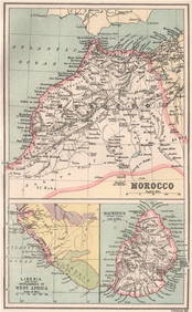
MOROCCO LIBERIA & MAURITIUS. Sierra Leone. BARTHOLOMEW 1886 old antique mapJasper524.5(9.8k)See Sold PriceFeb 28, 2024
NILE VALLEY. Upper & Lower. Egypt Sinai Nubia Sudan Abyssinia. BLACKIE 1886 mapJasper524.5(9.8k)See Sold PriceFeb 28, 2024
Central Africa. Congo Zambia Tanzania Kenya Mozambique. BARTHOLOMEW 1886 mapJasper524.5(9.8k)See Sold PriceFeb 28, 2024
MAGHREB. North Africa. Marocco Algeria and Tunis. BLACKIE 1886 old antique mapJasper524.5(9.8k)See Sold PriceFeb 28, 2024
Showers of Red Dust. Africa. Sahara 1886 old antique vintage map plan chartJasper524.5(9.8k)See Sold PriceFeb 28, 2024
EARLY COLONIAL WEST AFRICA. Empires of Sokoto Gando Mas.Tribes.Fellatah 1886 mapJasper524.5(9.8k)See Sold PriceFeb 28, 2024
Robert H Labberton - Map of The Territory of the Present United States - The territory of theProverde Auctions4.3(3)See Sold PriceFeb 28, 2024