Sold[LOUISIANPLANTATION MAP] Armant St.[LOUISIANA PLANTATION MAP] Armant St. James Plantation , c. 1870, watercolor and ink on paper, showing details of acreage, buildings, forest and the Mississippi River, with decorative border incorporaSee Sold Price
Booth Poverty Map: St John's Wood, 1902Map: 'Map G - Hampstead & St John's Wood (1900)' Date Printed: 1902 Image Size: Approx 45.0 x 29.0cm, 17.75 x 11.5 inches (Large) Type: Antique coloured linen-backed folding map. Artist/Cartographer/ESee Sold Price
SoldANTIQUE 17th/18th c MAP ST PAULAntique 17th/18th c. Map showing the travels of The Apostles and St. Paul in the Mediterranean. Professionally framed and matted, measures 23"x26"x1". Weight 7 pds. PROVENANCE: A Private Charleston SCSee Sold Price
SoldUS GEOLOGICAL MAP ST. HELENA SOUND-SAVANNAH RIVERLARGE FRAMED US GEOLOGICAL SURVEY MAP ST. HELENA SOUND-SAVANNAH RIVERSee Sold Price
Sold1757 Bellin Map St Lawrence River CanadaCarte Du Cours Du Fleuve de St. Laurent..:, printed by Jacques Bellin in 1757, Paris. Shows portion of the Saint Lawrence River including Quebec. Fine, measures 13.75 x 9.5. Reserve: $100.00 Shipping:See Sold Price
Thomson: Antique Map St. Christophers, Nevis & St LuciaTitle/Content of Map: 'St Christophers. Nevis. St Lucia' A map of the British West Indian islands of St Kitts and Nevis, and St Lucia. Caribbean Date Printed: 1817 Image Size: Approx 53.5 x 65.5cm, 21See Sold Price
SoldR.E. Lee maps St. Houis harbor 1837Title: Map of the Harbor of St. Louis, Mississippi River, Oct. 1837. Surveyed by Lt. R.E. Lee, Corps of Engineers... Author: U.S. Government Description: Engraved map. 42x107 cm. (16½x42").One of thrSee Sold Price
Sold16TH C. COLORED MAP, ST. HELENA, LINSCHOTEN15 by 19.5 in. (sight), framed, 16 by 20.75 in.See Sold Price
EMANUEL BOWEN, MAP, ST. KITTS, 14" X 17"EMANUEL BOWEN, MAP, ST. KITTS, 14" X 17", 18TH C.:Island of St. Kitts (St. Christopher) and Bermuda; black and white, signed, not dated, 14 1/8" x 17 1/8", 19" x 22 7/8" paper; center fold; unframed.See Sold Price
SoldLARGE FRAMED MAP ST GEORGES CHANNEL IRISH COASTLARGE FRAMED MAP OF ST GEORGES CHANNEL AND IRISH COAST - APPROX. 62" X 58" OVERALLSee Sold Price
Sold1575 Braun & Hogenberg Antique Map, St OmerSt. Omer, Calais, France. Original hand colored bird's-eye-view map, published by Georg Braun & Frans Hogenberg for the 1575 atlas of town plans Civiates Orbis Terrarum Vol II (1572-1612) intended asSee Sold Price
SoldHand Colored Map St. Francisco De CampecheHand Colored Map St. Francisco De Campeche by John Ogilby, London, 1671 - Excellent condition - 11 3/4" x 14 1/4"See Sold Price
SoldRobert E. Lee Maps St. Louis Harbor 1837Title: No. 3 Map of the Harbor of St. Louis, Mississippi River Author: Lee, Robert E. Description: Engraved map, on two sheets joined together. 42x107 cm. (16½x42").One of the maps Lee produced of thSee Sold Price
SoldMap "St. Helena Sound to Savannah River"NOAA #11513 nautical map "St. Helena Sound to Savannah River", North American 1927 Datum; black metal frame; 45 1/4"W, 37 1/2"H; abrasions to frame, staining to bottom margin of mapSee Sold Price
Sold1853-4 Map St. Paul To Rivere Des Lacs - Map No 11853-4 Map St. Paul To Rivere Des Lacs - Map No 1. Map is under shrink wrap and on cardboard, some tears on one side. Measures approx. 24''H x 36''W. Some text on this map reads: ''Explorations and suSee Sold Price
MAP, St. Petersburg, Russia, OttensSt. Petersburg, Russia. Reiner and Joshua Ottens, Nova ac Verissima Urbis St. Petersburg ab Imperatore Russico Petro Alexii F. Conditae, Item Fl. Nevae, Fossae Jussu Imp. Russ..., 1720 (circa). BlackSee Sold Price
SoldFramed Map St. MartinFramed Map St. Martin, Between the Atlantic Ocean and the Caribbean Sea, Framed 18.5" x 2.5", Under Glass.See Sold Price
MAP, St. Kitts & Barbados, Le RougeSt. Kitts & Barbados. Le Rouge, Isle St. Christophle une des Antilles aux Anglois [on sheet with] La Barbade une des Antilles aux Anglois Divisee par Paroises, from Atlas Nouvea Portatif..., 1748 (cirSee Sold Price
Larmat: LOIRE VINEYARD MAP St Nicholas BourgueilTITLE/CONTENT OF MAP: ' "Les Vins des Coteaux de la Loire" - Bourgueil, St. Nicholas-de-Bourgueil, Chinon, Montlouis, Jasnières' DATE PRINTED: 1946 IMAGE SIZE: Approx 41.5 x 63.5cm, 16.25 x 25 inchesSee Sold Price
LSE POVERTY OS PROOF MAP St Johns Wood Maida Vale Lisson Grove Regents Park 1928Title: LSE POVERTY OS PROOF MAP St Johns Wood Maida Vale Lisson Grove Regents Park 1928 Description: [Ordnance Survey] Edition of 1915 - London Sheet IV. 8. - Middlesex Sheet XVI. 8. St John's Wood -See Sold Price
BOOTH POVERTY MAP St John's Wood Hampstead Maida Vale Belsize Park Swiss C 1902Title: BOOTH POVERTY MAP St John's Wood Hampstead Maida Vale Belsize Park Swiss C 1902 Description: Map G - Hampstead & St John's Wood (1900)' by Charles Booth assisted by Jesse Argyle, Ernest Aves, GSee Sold Price
LOIRE VINEYARD MAP St Nicholas Bourgueil ChinonTITLE/CONTENT OF MAP: ' "Les Vins des Coteaux de la Loire" - Bourgueil, St. Nicholas-de-Bourgueil, Chinon, Montlouis, Jasnières' Date: 1946 IMAGE SIZE: Approx 41.5 x 63.5cm, 16.25 x 25 inches (Large)See Sold Price
SoldMAP - St. Helena. PerrotSt. Helena. Aristide Michel Perrot, Carte de l'Ile Ste. Helene, 1815 (dated). Black & White. This handsome map depicts the mountainous topography of the island along with a bird's-eye plan of Fort JamSee Sold Price
MAP - St. Lucia. BellinSt. Lucia. Jacques Nicolas Bellin, Karte von der Insel St. Lucia, 1758 (dated). Hand Color. This is a German copy of Bellin's small map of the island of Saint Lucia in the Lesser Antilles. The map isSee Sold Price
Cincinnati Hamilton and Dayton RR Map -USGC 1889JM Hobby Supply and Railroad Artifact Auctions4.4(126)See Sold PriceFeb 24, 2024
Chicago Milwaukee and St Paul RY Panama Pacific Exposition Brochure-1915JM Hobby Supply and Railroad Artifact Auctions4.4(126)See Sold PriceFeb 24, 2024
Chicago Milwaukee and St Paul RY To the Lakes of Wisconsin and Minnesota Book-1909JM Hobby Supply and Railroad Artifact Auctions4.4(126)See Sold PriceFeb 24, 2024
Chicago Milwaukee and St Paul RY Why and Wherefore Book-1886JM Hobby Supply and Railroad Artifact Auctions4.4(126)See Sold PriceFeb 24, 2024
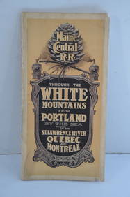
Maine Central RR Through the White Mtns-Portland to the St Lawrence River Book-1901JM Hobby Supply and Railroad Artifact Auctions4.4(126)See Sold PriceFeb 24, 2024
17TH C. MAP OF THE BERKSHIRES BY JOHN SPEED, FRAMEDThomaston Place Auction Galleries4.4(389)See Sold PriceFeb 24, 2024
Johann Homann Hand-Colored Map Engraving, c. 1730Auctions at Showplace4.6(731)See Sold PriceMar 17, 2024
Map of St. Kitts and Nevis Depot de la Marine, Paris, 1758Global Auctions Company4.3(36)See Sold PriceMar 03, 2024
Map: A 19thC engraved and hand coloured map of St. Petersburg / Sanktpeterburga by W. B. Clarke.Claydon Auctioneers Ltd4.3(125)See Sold PriceFeb 26, 2024
1750 Bowen Map of Bermuda and St. Kitts -- A New & Accurate Map of Bermudas or Sommer's Islands...Jasper524.5(9.8k)See Sold PriceFeb 27, 2024
1764 Bellin Map of St. Kitts -- Carte de l'Isle St. ChristopheJasper524.5(9.8k)See Sold PriceFeb 27, 2024
WEST AFRICA Explorers' routes Senegal Ashanti. Mountains of Kong. SDUK 1857 mapJasper524.5(9.8k)See Sold PriceFeb 28, 2024
WEST AFRICA explorers' routes. Beaufort Gray Park Dochard Caillie. SDUK 1874 mapJasper524.5(9.8k)See Sold PriceFeb 28, 2024
BRITISH AFRICAN COLONIES. West Africa Ascension St. Helena Mauritius 1876 mapJasper524.5(9.8k)See Sold PriceFeb 28, 2024
WEST AFRICA. European colonies; Mauritius; Ascension; St Helena 1907 old mapJasper524.5(9.8k)See Sold PriceFeb 28, 2024
AFRICA shows 1911 Neukamerun border changes. Equatorial cross section 1912 mapJasper524.5(9.8k)See Sold PriceFeb 28, 2024
WEST AFRICA I Explorers' routes Senegal Ashanti Ivory Gold Coast. SDUK 1851 mapJasper524.5(9.8k)See Sold PriceFeb 28, 2024
AFRICAN ISLANDS.Mauritius Madagascar Madeira Canaries St Helena 1897 old mapJasper524.5(9.8k)See Sold PriceFeb 28, 2024
WEST AFRICA showing early explorers' routes & Mountains of Kong. SDUK 1844 mapJasper524.5(9.8k)See Sold PriceFeb 28, 2024
Theo. Hamm Brewing Co. St. Paul Birds Eye Factory MapMatthew Bullock Auctioneers4.7(1.8k)See Sold PriceMar 02, 2024
![[LOUISIANPLANTATION MAP] Armant St. First Image](https://p1.liveauctioneers.com/268/1779/767581_1_x.jpg?height=282&quality=95&width=282)
![[LOUISIANPLANTATION MAP] Armant St. (1 of 2)](https://p1.liveauctioneers.com/268/1779/767581_1_x.jpg?height=282&quality=70)
![[LOUISIANPLANTATION MAP] Armant St. First Image](https://p1.liveauctioneers.com/268/1779/767581_1_x.jpg?height=282&quality=1&width=282)