Sold[Maps] Boscovich, Stato Ecclesiastico, 1750Ruggiero Giuseppe Boscovich, Nuova carta geografica dello Stato Ecclesiastico. Incisione in rame con coloritura coeva dei confini in 15 parti. Dimensioni totali: mm 1230x680. Titolo e dati editorSee Sold Price
Pilosi: Antique View Japanese Man/Woman 1750Map: Beautiful print representing a scene showing a Japanese man and woman. Author: Giuseppe Pilosi Atlas: Lo stato presente di tutti i popoli del mondo 1737-50 Date: 1750 circa Technique: Copper etchSee Sold Price
TEMPIO CHINESEBeautiful print representing a chinese temple. Author: Giuseppe Pilosi Atlas: Lo stato presente di tutti i popoli del mondo 1737-50 Date: 1750 circa Technique: Copper etching Leaf Dimension: 21x12,5 cSee Sold Price
Sold2 Maps: Stato Del Gran Turco + Asia Minoris.[De Rossi/Middle East] 2 Maps. ++ Stato Del Gran Turco diviso ne suoi Beglierbati, o Governi, e ne Principati, che li sono Tributari. Elaborate map of the Middle East, including Greece, Italy, the CasSee Sold Price
SoldFrench Carte De L'amerique Map, 1750Map: Carte De L'amerique Publication Date: 1750 ca. Authors: ANONYMOUS Size: Octavo – 7.50 H x 5.50 W Inches Mid 18th Century French "L'Amerique." Shows the Gila River crossing the Colorato River. USee Sold Price
Sold2 Maps: Stato Del Gran Turco + Asia Minoris.[De Rossi/Middle East] 2 Maps. ++ Stato Del Gran Turco diviso ne suoi Beglierbati, o Governi, e ne Principati, che li sono Tributari. Elaborate map of the Middle East, including Greece, Italy, the CasSee Sold Price
Italy's General Map, 1750. Giovan Battista AlbrizziItaly's General Map, 1750. Giovan Battista Albrizzi (1698-1777). From Sign of the Atlas novissimo. William de L'isle '" - Venice, 2 Vol. 32.5 x 43.5 cm, copperplate. in frame briar 59x73 cm. Very goodSee Sold Price
Map 1750 Migration of Celts Gomerians & ScythiansHand-colored map from 1750, not a reprint, from an estate collection of antique maps. Measures 8-7/8" x 14-3/4" visible in wood frame. One of several antique maps in the auction today. Not laid down.See Sold Price
Plan of Rome / Topographia di Roma. ROCQUE, from NOLLI's earlier map 1750Title: Plan of Rome / Topographia di Roma. ROCQUE, from NOLLI's earlier map 1750 Description: Plan of Rome / Topographia di Roma [Plan of Rome]' by John Rocque / Giovanni Battista Nolli (Published inSee Sold Price
Bellin: Three Moluccan Islands Maps, 1750Carte des Isles voisines des Moluques Ceram, Bouro, Amboine, Banda, Neyra etc [and] Carte Particuliere de l'Isle d'Amboine [and] Isle de Banda A set of three maps of the "islands neighboring the MolucSee Sold Price
SoldJOHN GIBSON POLAND MAP 1750JOHN GIBSON POLAND MAP 1750 Map of Poland, from 1750, by John Gibson from "Modern History," page 567. Matted with a title paper in Spanish.See Sold Price
JOHN GIBSON POLAND MAP 1750JOHN GIBSON POLAND MAP 1750 Map of Poland, from 1750, by John Gibson from "Modern History," page 567. Matted with a title paper in Spanish.See Sold Price
JOHN GIBSON POLAND MAP 1750JOHN GIBSON POLAND MAP 1750 Map of Poland, from 1750, by John Gibson from "Modern History," page 567. Matted with a title paper in Spanish.See Sold Price
JOHN GIBSON POLAND MAP 1750JOHN GIBSON POLAND MAP 1750 Map of Poland, from 1750, by John Gibson from "Modern History," page 567. Matted with a title paper in Spanish.See Sold Price
SoldVaugondy: Antique Map of Western Hemisphere, 1750sTitle/Content of Map: 1750's Western Hemisphere Date Printed: 1750's Cartographer: Robert de Vaugondy Material/Medium: Paper Size: 6" x 8" Hand colored copperplate engraved. Published in Paris. GillesSee Sold Price
1750 Seale Map of Western Africa Coast During SlaveTitle/Content of Map: 1750 Seale Map of Western Africa Coast During Slave Trade Period -- A New and Correct Map of the Coast of Africa from Cape Blanco ... to the Coast of Angola ... Date: 1750 c., LoSee Sold Price
1750 Robert de Vangondy Map of Hispaniola andTitle/ Content of Map: 1750 Robert de Vangondy Map of Hispaniola and Martinique -- Isles de Saint Domingue ou Hispaniola, et de la Martinique Cartographer: G Robert de Vaugondy Year/Place: 1750, ParisSee Sold Price
1750 Seale Map of Western Africa Coast During SlaveTitle/Content of Map: 1750 Seale Map of Western Africa Coast During Slave Trade Period -- A New and Correct Map of the Coast of Africa from Cape Blanco ... to the Coast of Angola ... Date: 1750 c., LoSee Sold Price
Sold1750 Sauzet Map of Sri Lanka -- Insula Ceylan OlimTitle/Content of Map: 1750 Sauzet Map of Sri Lanka -- Insula Ceylan Olim Taprobana Nunc Incolis Lankawn Cartographer: H du Sauzet Year/Place: 1750 c., Amsterdam Size: 11.4 X 15 in. This is a rather raSee Sold Price
Sold1750 Robert de Vangondy Map of Hispaniola andTitle/Content of Map: 1750 Robert de Vangondy Map of Hispaniola and Martinique -- Isles de Saint Domingue ou Hispaniola, et de la Martinique Cartographer: G Robert de Vaugondy Year/Place: 1750, ParisSee Sold Price
Sold1750 Bowen Map of Islands off the Coast of Africa --Title/Content of Map: 1750 Bowen Map of Islands off the Coast of Africa -- Particular Draughts Of Some Of The Chief African Islands In The Mediterranean, As Also In The Atlantic And Ethiopic Oceans CaSee Sold Price
SoldBolla della Santità di Nostro Signore Papa ClementeBolla della Santità di Nostro Signore Papa Clemente Ottavo, Sopra il buon governo, & Amministratione dell'entrate, & beni delle Comunità dello Stato Ecclesiastico. Registrata apud Marcellum SecrSee Sold Price
SoldCoronelli, La Romagna...Coronelli Vincenzo Maria, La Romagna provincia dello Stato Ecclesiastico descritto e delineato... [Segue:] Ravenna ricercata. S.n.t. [ma Venezia: Convento dei Frari, 1708 ca.] 2 parti in 1 album in-8&See Sold Price
SoldCartografia - Cassini, Giovanna Maria.. Lo Stato ECartografia - Cassini, Giovanna Maria.. Lo Stato Ecclesiastico diviso nelle sue provincie.Roma, Calcografia Camerale, 1805. In 2° oblungo, 458 x 695 mm., 14 fogli raffiguranti le terre della CSee Sold Price
Crams Township and Railroad Map of New York-1890JM Hobby Supply and Railroad Artifact Auctions4.4(126)See Sold PriceFeb 24, 2024
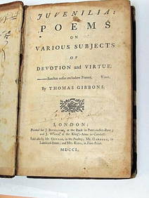
Thomas Gibbons Juvenalia 1750 Very Rare 1st Edition Full CalfLuis Porretta Fine Arts4.3(10)See Sold PriceMar 02, 2024
1885 CIVIL WAR 1ed Famous Memoirs US Grant Sheridan Sherman 6v RARE LOT MapsSchilb Antiquarian Rare Books4.8(421)See Sold PriceMar 10, 2024
Large lot of assorted prints. 18th-20th century. To include: North American and other maps, CivilTremont Auctions4.6(293)See Sold PriceFeb 25, 2024
Large Assortment of Railroad Items - Insulators, Globes, Hand Bell, Posters, Maps, Timetables,Rail & Road Auctions4.6(165)See Sold PriceMar 07, 2024
A Meissen Figure of A Leopard Circa 1750China Luban Art & Antique, Inc.4.4(78)See Sold PriceFeb 24, 2024
Collection of Allied Military Silk Printed Maps, WWII Era and LaterMaterial Culture4.6(765)See Sold PriceFeb 29, 2024
Rand McNally Railroad Map Cabinet w/ 21 Railroad MapsRail & Road Auctions4.6(165)See Sold PriceMar 08, 2024
[MAP]. [ALBRIZZI, Giambatista, 1698-1777]. Carta Geografica...Potter & Potter Auctions4.6(539)See Sold PriceMar 07, 2024
Willem Blaeu, Etc. 17th C. Antiquarian Maps, 2Auctions at Showplace4.5(726)See Sold PriceMar 17, 2024
Putnam - First Map of the State of Ohio by Rufus PutnamTrillium Antique Prints & Rare Books4.5(30)See Sold PriceFeb 24, 2024
Carey, pub. 1796 - Map of the Tennassee State formerly part of North Carolina (Tennessee)Trillium Antique Prints & Rare Books4.5(30)See Sold PriceFeb 24, 2024
De Jode, Rare, pub. 1593 - Map of Africa (Africae Vera Forma, et Situs)Trillium Antique Prints & Rare Books4.5(30)See Sold PriceFeb 24, 2024
1750 Bowen Map of Bermuda and St. Kitts -- A New & Accurate Map of Bermudas or Sommer's Islands...Jasper524.5(9.8k)See Sold PriceFeb 27, 2024
![[Maps] Boscovich, Stato Ecclesiastico, 1750 First Image](https://p1.liveauctioneers.com/1306/149407/75466433_1_x.jpg?height=282&quality=95&version=1567670607&width=282)
![[Maps] Boscovich, Stato Ecclesiastico, 1750 (1 of 1)](https://p1.liveauctioneers.com/1306/149407/75466433_1_x.jpg?height=282&quality=70&version=1567670607)
![[Maps] Boscovich, Stato Ecclesiastico, 1750 First Image](https://p1.liveauctioneers.com/1306/149407/75466433_1_x.jpg?height=282&quality=1&version=1567670607&width=282)


![[MAP]. [ALBRIZZI, Giambatista, 1698-1777]. Carta Geografica... (1 of 1)](https://p1.liveauctioneers.com/928/318880/171361280_1_x.jpg?height=282&quality=70&version=1707501302)


