Sold19TH C. MAPS OF THE WEST AND INDIAN TERRITORIESMexico and Internal Provinces," map no. 38, 'Geographical, Statistical and Historical map of Mexico,' engraved by Young & Delleker, 'prepared from Humboldt's map and other documents by J. Finlayson.'See Sold Price
SoldNative Art: 19th C. MapNative Art: 19th C. Map Cherokee -Nation of- Indians 1884 Territory Assigned. 32 x 23 inchesSee Sold Price
SoldMilitaria : A late 19thC American map , entitled 'Militaria : A late 19thC American map , entitled ' Oklahoma and Indian Territory ' , with the locations of tribal populations within the state , depicting Cheyenne in the West , Commanche , Apache andSee Sold Price
SoldMilitaria : A late 19thC American map , entitled 'Militaria : A late 19thC American map , entitled ' Oklahoma and Indian Territory ' , with the locations of tribal populations within the state , depicting Cheyenne in the West , Commanche , Apache andSee Sold Price
SoldFOUR MAPS OF INDIAN TERRITORY AND SOUTH WEST, 19TH CEN.Includes an 1872 Gray's Atlas map of Indian Territory, by G.W. & C.B. Colton, 13.75 x 17 inches. An A.A. Grant 'Railroad and County Map of Indian Terr.,' 17.25 x 23.5 inches. Two similar Wells, FargoSee Sold Price
SoldTwo American 19thC MapsTwo American 19thC Maps, A) 19thC map of United States western states, including California, Oregon, Utah, Washington, New Mexico, Nebraska, Kansas, Indian Territory, framed and matted under glass, siSee Sold Price
SoldC. 1857 LITHOGRAPHIC MAP OF NORTH WEST CANADAA large lithographic map, "Map of the North West Part of Canada, Indian Territories & Hudson's Bay", Thomas Devine Surveyor and Cartographer (b. 1818, Ireland), circa 1857, folding marks and some foxiSee Sold Price
SoldMAPS, 2, 19TH C., 12" X 16", CANADA & MICHIGANMAPS, TWO, 19TH C., 12" X 16", CANADA & MICHIGAN:Including 1 engraved by J. & C. Walker, "North America: Sheet V, The North West and Michigan Territories", published by Baldwin & Cradock, 1833, 12 1/2See Sold Price
SoldS. Walker, "Map of the United States," 19th c., sS. Walker, "Map of the United States," 19th c., showing the Indian Territory in Oklahoma, framed, H.- 10 1/8 in., W.- 16 1/8 in.See Sold Price
SoldNative Art: 19th C. MapNative Art: 19th C. Map Cherokee - Nation of - Indians 1884 Cessions of Land. 34 x 32 inchesSee Sold Price
SoldGroup of 2 Cherokee nation maps with book.Includes ++ Cherokee "Nation of" Indians showing territorial limits. C.C. Royce 1884 map, 30" x 33". ++ Cherokee "Nation of" Indians showing territory originally assigned west of Mississippi. C.C. RoySee Sold Price
Sold10 Antique War Department/Survey Maps of the West[Ten Antique War Department/Survey Maps of the Western United States], 19th c., incl. "Sketch of the Country...of Kansas", "Colorado Territory"; "From the Pimas Villages to Fort Fillmore", "From FortSee Sold Price
SoldThree mid-19th century maps of the West IndiesTitle: Three mid-19th century maps of the West Indies Author: ** Description: Includes: Knight, Charles. The Antilles or West-Indian Islands. Engraved by J & C. Walker. 30x39 cm. 1852. * Thomas, CowpeSee Sold Price
Three mid-19th century maps of the West IndiesTitle: Three mid-19th century maps of the West Indies Author: ** Description: Includes: Knight, Charles. The Antilles or West-Indian Islands. Engraved by J & C. Walker. 30x39 cm. 1852. * Thomas, CowpeSee Sold Price
Cherokee Nation of Indians MapsMaps showing the Territory Originally Assigned to the Cherokee "Nation of" Indians West of the Mississippi,Also the boundaries of the Territory Now Occupied or Owned by Them. C. C. Royce 1884. The secSee Sold Price
Sold19thc Map: West India Islands, John Tallis & CoFramed 19th century antique map. West India Islands, John Tallis & Company, London and New York, Published 1851. Hand colored, the map drawn and engraved by J. Rapkin. The illustrations by H. Warren &See Sold Price
SoldAntique West Indian Teacher's Mahogany flip top deskTitle: 19th c. West Indian Teacher's Mahogany wooden flip top writing desk Medium: wood Dimensions: 37.75 x 35.75 x 24 inches Provenance: Frances Debroff CollectionSee Sold Price
SoldTwo Late 19th C. Maps Showing Indian Reservationsboth "Compiled Under The Direction Of The Hon. T.J. Morgan", dated 1890 and 1891, both being 23 5/8" x 34 3/4"See Sold Price
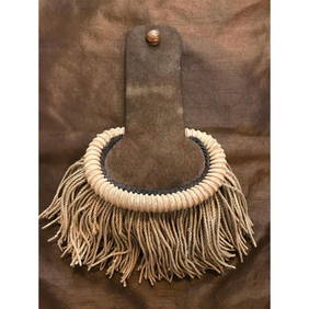
Sold3 piece Indian lot3 piece Indian lot including Navajo black vase signed " Adakai Navajo", 19th c. Mid-West Indian beaded Priest's stole possibly Elk skin; & beaded small drum. Lacking beads; tears; stains. Vase measureSee Sold Price
Boudinot, Map of the Indian Territory..BOUDINOT, Elias C. Map of Indian Territory. Washington, D.C.: Julius Bien & Co., 1879. Lithographed, original hand color in outline. 18 x 23 ¾ inches (unframed).See Sold Price
Sold(16) 19TH C. MAPS OF THE WEST INDIES IN FOLIO,Including: "L'Isle de Ste. Domingue, et celle de Porto Rico", by Bonne, hand colored engraving,1778, 10" x 14 1/2"; PLUS "West Indies", Smith's Atlas, 1808, hand colored engraving, 1808, 11" x 14"; PLSee Sold Price
Sold19th C Map of Alaskan Territory. 26" x 24".19th C Map of Alaskan Territory. 26" x 24".See Sold Price
18/19TH C. MAPS OF THE WEST INDIES, 518/19TH C. MAPS OF THE WEST INDIES, 5, 10" X 8" TO 18 3/4" X 13":Sizes are plate sizes. St. St. Dominica, by M. Bellin, "Suivant la Decouverte de l'Anne 1492", 1754, hand colored, Tom XII No. 2, 9" XSee Sold Price
SoldTEXAS C. 1886 MAP, PART OF INDIAN TERRITORYFramed map of Texas, c. 1886, showing counties with an inset for the Panhandle and a portion of the Indian Territory (Cheyennes, Arrapahoes), sight: 11.75"h, 17"w, overall: 21.75"h, 25.75"w, 4.25lbs SSee Sold Price
18TH C. ANTIQUE MAP: FRENCH & INDIAN WAR, FRAMEDThomaston Place Auction Galleries4.4(393)See Sold PriceFeb 24, 2024
19th C. Staffordshire Indian Ironstone Soup Bowls, PairNorthgate Gallery, Inc.4.5(36)See Sold PriceMar 02, 2024
Map: A 19thC engraved and hand coloured map of Buckingham titled A New Map of BuckinghamshireClaydon Auctioneers Ltd4.3(125)See Sold PriceFeb 26, 2024
Map: A 19thC engraved map of West Riding, titled A Map of the North Part of the West Riding ofClaydon Auctioneers Ltd4.3(125)See Sold PriceFeb 26, 2024
19th C. Indian Bronze Statue of Nandi (Vahana of Shiva)Artemis Fine Arts4.8(1.4k)See Sold PriceFeb 26, 2024
Rare 19thc Colton Map, Argentine Republic, Chile, Uruguay, PataguayConnoisseur Auctions3.9(336)See Sold PriceMar 16, 2024
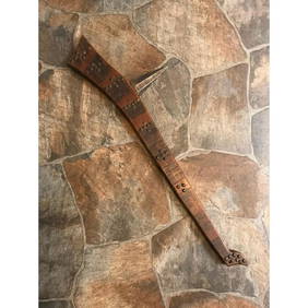
Rare 19thc Native American Indian Gunstock War ClubConnoisseur Auctions3.9(336)See Sold PriceMar 16, 2024
A SOUTH-WEST INDIAN SANDALWOOD CARD CASE, 19TH CENTURYElstob Auctioneers4.3(57)See Sold PriceFeb 25, 2024
Antique Ivanhoe Special by Indian Bicycle CompanyGrant Zahajko Auctions, LLC4.7(1k)See Sold PriceMar 06, 2024
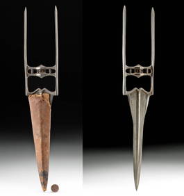
19th C. Indian Mughal Steel Katar w/ Leather SheathArtemis Fine Arts4.8(1.4k)See Sold PriceMar 01, 2024