KONVOLUT AUS VIER LANDKARTEN RUSSLAND UND CHINA Abraham Ortelius, Willem Blaeu, Johannes Blaeu,Hargesheimer Kunstauktionen Duesseldorf4.5(136)See Sold PriceMar 09, 2024
SoldBritish Isles.- Ortelius (Abraham) - BritannicarumBritish Isles, north oriented to the right, ornamental title and dedication cartouches, numerous ships including 2 large galleons, engraved map, 365 x 505mm., Latin text on verso, 1st edition with theSee Sold Price
SoldBritish Isles.- Ortelius (Abraham) BritannicarumBritish Isles.- Ortelius (Abraham) Britannicarum Insularum Vetus Descriptio, two-sheet map of ancient Britain, probably engraved by Jan Wierix, with four ornate strap-work cartouches, a naval battle iSee Sold Price
SoldBritish Isles.- Ortelius (Abraham) BritannicarumBritish Isles.- Ortelius (Abraham) Britannicarum Insularum Typus, map of Roman Britain based on information from Mercator's 1564 map of the British Isles, oriented with north to the right, three decorSee Sold Price
British Isles.- Ortelius (Abraham) BritannicarumBritish Isles.- Ortelius (Abraham) Britannicarum Insularum Typus, map of Roman Britain based on information from Mercator's 1564 map of the British Isles, oriented with north to the right, three decorSee Sold Price
SoldOrtelius (Abraham) Britannicarum InsularumOrtelius (Abraham) Britannicarum Insularum Typus,British Isles, ornamental title and dedication cartouches, numerous ships including 2 large galleons, engraved map with full hand-colouring, 36See Sold Price
Ortelius (Abraham) Britannicarum Insularum TypusOrtelius (Abraham) Britannicarum Insularum Typus,British Isles, ornamental title and dedication cartouches, numerous ships including 2 large galleons, engraved map with full hand-colouring, 36See Sold Price
Ortelius (Abraham) - Britannicarum Insularum Typus,British Isles with north oriented to the right, ornamental title and dedication cartouches, numerous ships including 2 large galleons, engraved map, 367 x 507mm., Italian text verso, pale browning oveSee Sold Price
Ortelius (Abraham) - Britannicarum Insularum Typus,1st edition, the British Isles with north oriented to the right, ornamental title and dedication cartouches, numerous ships including 2 large galleons below, engraved map with hand-colouring on thickSee Sold Price
SoldHAND COLOURED MAP OF BRITISH ISLESAbraham Ortelius. Britannicarum Insularum Typus, hand coloured map of the British Isles, dated 1595, 50 x 36cm, double glazed with text verso, in a modern frameSee Sold Price
SoldBritish Isles.- Ortelius (Abraham) Angliae, Scotiae, etBritish Isles.- Ortelius (Abraham) Angliae, Scotiae, et Hiberniae, sive Britannicar Insularum Descriptio, Ortelius' earliest map of Britain, oriented with north to the right, and embellished with twoSee Sold Price
SoldBritish Isles.- Ortelius (Abraham) Angliae, Scotiae, etBritish Isles.- Ortelius (Abraham) Angliae, Scotiae, et Hiberniae, sive Britannicar Insularum Descriptio, Ortelius' earliest map of Britain, oriented with north to the right, and embellished with twoSee Sold Price
SoldBritish Isles.- Ortelius (Abraham) Angliae, Scotiae, etBritish Isles.- Ortelius (Abraham) Angliae, Scotiae, et Hiberniae, sive Britannicar: Insularum Descriptio, map of the British Isles oriented with north to the right, with the north of France to the leSee Sold Price
SoldBritish Isles.- Ortelius (Abraham) Angliae, Scotiae, etBritish Isles.- Ortelius (Abraham) Angliae, Scotiae, et Hiberniae, sive Britannicar Insularum Descriptio, Ortelius' earliest map of Britain, oriented with north to the right, and embellished with twoSee Sold Price
British Isles.- Ortelius (Abraham) Angliae, Scotiae, etBritish Isles.- Ortelius (Abraham) Angliae, Scotiae, et Hiberniae, sive Britannicar: Insularum Descriptio, map of the British Isles oriented with north to the right, with the north of France to the leSee Sold Price
SoldAngliae Scotiae et Hiberniae 1572 MapThe British Isles by Abraham Ortelius. The hand tinted copperplate engraved map has been nicely framed and with a reverse painted glass perimeter. Some slight discoloration consistent with age. OveralSee Sold Price
SoldOrtelius, Abraham. Septentrionalivm Regionvm Descript.(Antwerp, 1570s-1580s), copperplate engraving of the British Isles, Scandinavia, Iceland, Greenland, and the eastern edge of Canada; hand-coloring. From the Theatrum Orbis Terrarum. Unframed. Sheet 15See Sold Price
SoldOrtelius, Abraham. Angliae, Scotiae et HiberniaeOrtelius, Abraham Angliae Scotiae et Hiberniae 1572 Copperplate engraving; old coloured Printed area: 50.3 x 34.5 cm; 19.8 x 13.5 in The British Isles are depicted from an unusual westerly orientatedSee Sold Price
SoldOrtelius (Abraham) - Septentrionalium Regionum Descrip.north Atlantic and north-west Europe, including Scandinavia and the British Isles, ships and sea- monsters, title cartouche, lower right, decorated with a winged creature and a monkey, engraved map, 3See Sold Price
Sold(MAP) ORTELIUS, ABRAHAM. Angliae, Scotiae, et(MAP) ORTELIUS, ABRAHAM Angliae, Scotiae, et Hiberniae, sive Britannicar: Insularum descriptio. [London, n.d.] Engraved map depicting the British Isles with decorative cartouches to upper and lower riSee Sold Price
SoldOrtelius (Abraham) - Angliae, Scotiae, et Hiberniae,the British Isles, Ireland and the north coast of France, north oriented to the right, strapwork cartouches upper and lower right, a galleon and 4 sail boats, engraved map with hand-colouring, 345 x 5See Sold Price
SoldOrtelius (Abraham) - Angliae, Scotiae, et Hiberniae,the British Isles, Ireland and the north coast of France, north oriented to the right, with strapwork cartouches, upper and lower right, a galleon and 4 sail boats, engraved map, 345 x 500mm., ItalianSee Sold Price
SoldOrtelius (Abraham) Angliae, Scotiae, et HiberniaeOrtelius (Abraham) Angliae, Scotiae, et Hiberniae, sive Britannicar: Insularum descriptio,the British Isles, Ireland and the north coast of France, north oriented to the right, with strapworkSee Sold Price
SoldOrtelius (Abraham) - Angliae, Scotiae, et Hiberniae,the British Isles, Ireland and the north coast of France, north oriented to the right, strapwork cartouches upper and lower right, a galleon and 4 sail boats, engraved map with hand-colouring, 345 x 5See Sold Price
SoldOrtelius (Abraham) Septentrionalium Regionum DescrOrtelius (Abraham) Septentrionalium Regionum Descrip.the North Atlantic and Arctic region, extending to include the British Isles, Scandinavia, northern Europe, Greenland, Iceland and northernSee Sold Price
LATE 17TH C. FRENCH MAP OF THE NEW WORLD BY ALEXIS-HUBERT JAILLOT (1632-1712)Thomaston Place Auction Galleries4.4(386)See Sold PriceFeb 24, 2024
ABRAHAM ORTELIUS (1527-1598) MAP OF ROMAN GAUL (FRANCE)Thomaston Place Auction Galleries4.4(386)See Sold PriceFeb 24, 2024
ATTR TO LIBERTY COMPANY ARTS CRAFTS COPPER MIRRORAntique Arena Inc.4.5(852)See Sold PriceFeb 24, 2024
ARTS AND CRAFTS HAMMERED LAMP BY FREDRICK FIFIELDAntique Arena Inc.4.5(852)See Sold PriceFeb 24, 2024
AN ANTIQUE FOLDING MAP OF THE BRITISH ISLES DATED 1873Hutchinson Scott Auctioneers4.4(39)See Sold PriceFeb 28, 2024
Chatelain - 3 Maps of the British Isles (England, Ireland, Scotland)Trillium Antique Prints & Rare Books4.5(30)See Sold PriceFeb 24, 2024
De Jode, Rare, pub. 1593 - Map of the British Isles [England, Scotland, Ireland] (Angliae Scotiae etTrillium Antique Prints & Rare Books4.5(30)See Sold PriceFeb 24, 2024
Map: A 17thC engraved map of the British Isles titled A Generall Mapp of the Isles of GreatClaydon Auctioneers Ltd4.3(125)See Sold PriceFeb 26, 2024
Stanford, Edward 1901 Large Map. Geological Map of the British IslesAlbion Auctions4.6(336)See Sold PriceMar 01, 2024
Stanford, Edward 1901 Large Map. Hydrographical Map of the British IslesAlbion Auctions4.6(336)See Sold PriceMar 01, 2024
Stanford, Edward 1901 Large Map. Stereographical Map of The British IslesAlbion Auctions4.6(336)See Sold PriceMar 01, 2024
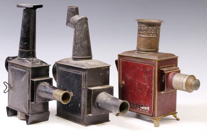
(3) MAGIC LANTERNS, DANNHORN, BRITISH & UNKNOWNAustin Auction Gallery4.7(1.2k)See Sold PriceApr 12, 2024


![De Jode, Rare, pub. 1593 - Map of the British Isles [England, Scotland, Ireland] (Angliae Scotiae et (1 of 2)](https://p1.liveauctioneers.com/6581/319571/171593327_1_x.jpg?height=282&quality=70&version=1707853304)