Marc Chagall-Limited Edition -Paris Opera Ceiling after ChagallArt Legacy Auctions4.5(223)See Sold PriceFeb 24, 2024
Salvador Dali Pantagruel Limited Edition Lithograph Hand signed and numberedArt Legacy Auctions4.5(223)See Sold PriceFeb 24, 2024
Pablo Picasso Bouquet of Peace Collection Domaine Picasso Limited Edition on paper.Art Legacy Auctions4.5(223)See Sold PriceFeb 24, 2024
A RARE MAXFIELD PARRISH JACK AND THE BEANSTALK PRINTSoulis Auctions4.8(953)See Sold PriceFeb 24, 2024
LARGE MECHANICAL PRINT 'STARS' AFTER MAXFIELD PARRISHSoulis Auctions4.8(953)See Sold PriceFeb 24, 2024
Heinrich Aldegrever, etc. 15 old master prints. 16th-17th centuries. Aldegrever works include "ManTremont Auctions4.5(297)See Sold PriceFeb 25, 2024
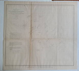
SoldU S Coast Survey 1896 Map. Missouri & Kansas"Sketch showing Route Line of Spirit Levels" Lithograph Map Published 1896, Washington for "U.S. Coast and Geodetic Survey" Folds as issued. Rare. Paper Size: 16 x 11.5 inch (40 x 29cm) Good ConditionSee Sold Price
SoldU S Coast Survey 1896 Map. Missouri & Kansas"Sketch showing Route Line of Spirit Levels from Jefferson City Mo. To Holliday, Kans" Lithograph Map Published 1896, Washington for "U.S. Coast and Geodetic Survey" Folds as issued. Rare. Paper Size:See Sold Price
U S Coast Survey 1896 Map. Missouri & Kansas"Sketch showing Route Line of Spirit Levels" Lithograph Map Published 1896, Washington for "U.S. Coast and Geodetic Survey" Folds as issued. Rare. Paper Size: 16 x 11.5 inch (40 x 29cm) Good ConditionSee Sold Price
U S Coast Survey 1896 Map. Missouri & Kansas"Sketch showing Route Line of Spirit Levels" Lithograph Map Published 1896, Washington for "U.S. Coast and Geodetic Survey" Folds as issued. Rare. Paper Size: 16 x 11.5 inch (40 x 29cm) Good ConditionSee Sold Price
U S Coast Survey 1896 Map. Missouri & Kansas"Sketch showing Route Line of Spirit Levels" Lithograph Map Published 1896, Washington for "U.S. Coast and Geodetic Survey" Folds as issued. Rare. Paper Size: 16 x 11.5 inch (40 x 29cm) Good ConditionSee Sold Price
SoldU S Coast Survey 1896 Large Map. Colorado Utah Kansas"Triangulation between Western Kansas and Eastern Utah along or near the 39th Parallel" Large Lithograph Map Published 1896, Washington for "U.S. Coast and Geodetic Survey" Folds as issued. Rare. PapeSee Sold Price
U S Coast Survey 1896 Large Map. Colorado Utah Kansas"Triangulation between Western Kansas and Eastern Utah along or near the 39th Parallel" Large Lithograph Map Published 1896, Washington for "U.S. Coast and Geodetic Survey" Folds as issued. Rare. PapeSee Sold Price
U S Coast Survey 1896 Large Map. Colorado Utah Kansas"Triangulation between Western Kansas and Eastern Utah along or near the 39th Parallel" Large Lithograph Map Published 1896, Washington for "U.S. Coast and Geodetic Survey" Folds as issued. Rare. PapeSee Sold Price
U S Coast Survey 1896 Large Map. Colorado Utah Kansas"Triangulation between Western Kansas and Eastern Utah along or near the 39th Parallel" Large Lithograph Map Published 1896, Washington for "U.S. Coast and Geodetic Survey" Folds as issued. Rare. PapeSee Sold Price
U S Coast Survey 1896 Large Map. Colorado Utah Kansas"Triangulation between Western Kansas and Eastern Utah along or near the 39th Parallel" Large Lithograph Map Published 1896, Washington for "U.S. Coast and Geodetic Survey" Folds as issued. Rare. PapeSee Sold Price
SoldU S Coast Survey 1896 Map. USA - Telegraphic Stations"Base Map of the United States" by W. W. Duffield. Telegraphic Stations. Lithograph Map Published 1896, Washington for "U.S. Coast and Geodetic Survey" Folds as issued. Rare. Paper Size: 30 x 24 inchSee Sold Price
SoldU S Coast Survey 1896 Map. Delaware Bay, Salt Lake Utah"Sketch Showing Extension of Triangulation of Delaware Bay with sub-sketches of Salina and Salt Lake Bases" Large Lithograph Map Published 1896, Washington for "U.S. Coast and Geodetic Survey" Folds aSee Sold Price
SoldU S Coast Survey 1896 Map. Magnetic Declination"Change of Magnetic Declination 1896-1900" Lithograph Map Published 1896, Washington for "U.S. Coast and Geodetic Survey" Folds as issued. Rare. Paper Size: 21 x 17.5 inch (54 x 44cm) Good ConditionSee Sold Price
SoldU S Coast Survey 1896 Map. California Nevada Boundary"Boundary Survey between California and Nevada. Sheet 1" Lithograph Map Published 1896, Washington for "U.S. Coast and Geodetic Survey" Folds as issued. Rare. Paper Size: 20 x 19.5 inch (50 x 49cm) GoSee Sold Price
SoldU S Coast Survey 1896 Map. California Nevada Boundary"Boundary Survey between California and Nevada. Sheet 1" Lithograph Map Published 1896, Washington for "U.S. Coast and Geodetic Survey" Folds as issued. Rare. Paper Size: 20 x 19.5 inch (50 x 49cm) VeSee Sold Price
SoldU S Coast Survey 1896 Map. Base Map of AlaskaLithograph Map Published 1896, Washington for "U.S. Coast and Geodetic Survey" Folds as issued. Rare. Paper Size: 18.5 x 11.5 inch (47 x 29cm) Good ConditionSee Sold Price
U S Coast Survey 1896 Map. California Nevada Boundary"Boundary Survey between California and Nevada. Sheet 1" Lithograph Map Published 1896, Washington for "U.S. Coast and Geodetic Survey" Folds as issued. Rare. Paper Size: 20 x 19.5 inch (50 x 49cm) GoSee Sold Price
SoldU S Coast Survey 1896 LG Map. West USA California Texas"Sketch of General Progress June 30. 1896." Showing Central and Western US, with part of Mexico. From Mississippi/Wisconsin through to West Coast. Large Lithograph Map Published 1896, Washington for "See Sold Price
SoldU S Coast Survey 1896 LG Map. New Orleans Texas Florida"Sketch of General Progress June 30. 1896" Showing Southern, Eastern and Mid West States, incl Florida, Texas, Gulf of Mexico, Georgia etc. Large Lithograph Map Published 1896, Washington for "U.S. CoSee Sold Price
SoldU S Coast Survey 1896 LG Map. Base Map of the USA"Base Map of the United States" by W. W. Duffield. Showing Positions of Tide and Gravity Stations. Large Lithograph Map Published 1896, Washington for "U.S. Coast and Geodetic Survey" Folds as issued.See Sold Price
SoldU S Coast Survey 1896 LG Map. Gulf Coast. Florida, MI"Sketch Showing Progress of Surveys on the Gulf Coast Lake Pontchartrain Mobile and Pensacola Bays" Detailed map showing New Orleans to Santa Rosa Sound, with inset showing Tortugas Harbor. Large LithSee Sold Price
SoldU S Coast Survey 1896 LG Map. Base Map of the USA Rare"Base Map of the United States" by W. W. Duffield. Large Lithograph Map Published 1896, Washington for "U.S. Coast and Geodetic Survey" Folds as issued. Rare. Paper Size: 30 x 24 inch (76 x 60cm) GoodSee Sold Price
SoldU S Coast Survey 1896 Base Map of The United States"Isogonic Chart of the United States for the Epoch January 1900" Large Lithograph Map Published 1896, Washington for "U.S. Coast and Geodetic Survey" Folds as issued. Rare. Paper Size: 30.5 x 23.5 incSee Sold Price
U S Coast Survey 1896 Base Map of The United States"Isogonic Chart of the United States for the Epoch January 1900" Large Lithograph Map Published 1896, Washington for "U.S. Coast and Geodetic Survey" Folds as issued. Rare. Paper Size: 30.5 x 23.5 incSee Sold Price
William Cruikshank (KS,MO,Canada,1848-1922) watercolor painting antiqueBroward Auction Gallery4.7(292)See Sold PriceMar 10, 2024
Central Railroad of New Jersey Map of Sandy Hook Route-ca. 1903JM Hobby Supply and Railroad Artifact Auctions4.4(127)See Sold PriceFeb 24, 2024
War Diary of 354th Infantry - 89th Division 1919North American Artifact Auctions4.7(198)See Sold PriceApr 20, 2024
The Sketchbook of Byron B Wolfe by Wolfe 1972 1st EditionNorth American Artifact Auctions4.7(198)See Sold PriceApr 20, 2024
[MAP]. NICHOLLS, Sutton (1668-1729). An Epitome of Sr. Will...Potter & Potter Auctions4.6(545)See Sold PriceMar 07, 2024
1852 CHART SHOWING POSITIONS of DAVIS'S SOUTH SHOAL & OTHER DANGERS antiqueJasper524.5(9.9k)See Sold PriceFeb 27, 2024
INDIA WITHIN THE GANGES SUSAN GOLE ILLUSTRATED MAPS EARLY CARTOGRAPHYJasper524.5(9.9k)See Sold PriceFeb 27, 2024
Central Africa. Congo Free State Rhodesia German East Africa. STANFORD 1896 mapJasper524.5(9.9k)See Sold PriceFeb 28, 2024
Ron Raymer (MO,KS,1943-2018) acrylic paintingBroward Auction Gallery4.7(292)See Sold PriceMay 19, 2024
Frederick Mulhaupt (KS,NY,MA,MO,1871-1938) oil painting antiqueBroward Auction Gallery4.7(292)See Sold PriceMay 19, 2024
US Post Lewis And Clark First Day Stamp Sheet BundleRapid Estate Liquidators and Auction Gallery4.5(1.1k)See Sold PriceFeb 29, 2024
West Coast U.S. Vintage Travel Maps, Brochures 46Grant Zahajko Auctions, LLC4.7(1k)See Sold PriceMar 06, 2024


![[MAP]. NICHOLLS, Sutton (1668-1729). An Epitome of Sr. Will... (1 of 1)](https://p1.liveauctioneers.com/928/318880/171361281_1_x.jpg?height=282&quality=70&version=1707501302)