SoldLARGE FRAMED MAP OF PARIS AND SURROUNDING AREASdated 1875, 23x34in., together with an offset map titled Magna Britannia et Hibernia Tabula, 12x15in.See Sold Price
Sold19TH C. MAP OF PARIS19TH C. MAP OF PARIS: Large framed map of Paris Circa Mid 1900's by Malte-Brun family, in frame. Approx. 35" h x 43" w.See Sold Price
''Departement de la Seine,'' color physical map.[France]. Departement De La Seine. Color lithograph map of Paris and surrounding areas, charting roads, rails, rivers, and political boundaries. Paris: Depot de la Guerre/ Lemercier & Cie., (c.1900?).See Sold Price
Sold19C French Maps Annotating French Revolution19th Century maps of Paris, France and surrounding areas annotated with colored ink in French with events of the French Revolution including the 1791 flight of King Louis XVI and the 1807 Coronation oSee Sold Price
SoldMagnificent 1886 Map of Pairs on Linen PlusExcellent lot of old Parisian maps and tour guides with the best being is a large 32x42" map of Paris and the surrounding 30 kilometers plus two other fold out maps and an early tour guide. Est.$200-3See Sold Price
SoldFramed map of The Nile riverFramed map of The Nile river and surrounding areas. Framed size 31"h x 21"w, sight size 31"h x 12 1/2"wSee Sold Price
Original travel poster France Ile de France Paris 1947France, Ile de France, map of areas surrounding Paris. Artwork by Jean Moles. Very good condition, folds, minor bumps on margins. 1947. 79x94.5See Sold Price
SoldParis monumental Paris: A. Taride, Folding, color mapMaps, France, Paris) Paris monumental [cover title] Paris: A. Taride, n.d. 4pp text. Folding, color map (22 x 27 1/2"), map of area surrounding Paris on verso. Tipped into original gilt-decorated clotSee Sold Price
SoldLarge Framed Map of London, 1861Depicts London from the South Side of the Thames, this was a fold-out supplement to the illustrated London News, February 9, 1861, Rob Loudon Sr. Folds, creases, water stains in areas. Overall size: 2See Sold Price
1764 Large Folding Map of London1764 Large Folding Map of London 1764 Map of London , measures 15 x 18”. From Gentleman’s Magazine series of maps of London and the surrounding area. Folding map, Fine condition. Please note thatSee Sold Price
1764 Large Folding Map of London1764 Map of London , measures 15 x 18". From Gentleman's Magazine series of maps of London and the surrounding area. Folding map, Fine condition. Shipping: Domestic: Flat-rate of $10.00 to anywhere wiSee Sold Price
SoldPARRY (J), HISTORICAL AND DESCRIPTIVE ACCOUNT OFPARRY (J), HISTORICAL AND DESCRIPTIVE ACCOUNT OF THE COAST OF SUSSEX, title vignette and other illustrations, Brighton 1833, and a large collection of books and maps of Sussex and the surrounding areaSee Sold Price
1764 Large Detailed Folding Map of London1764 Map of London , measures 15 x 18”. From Gentleman’s Magazine series of maps of London and the surrounding area. Folding map, Fine condition. Please note that this lot has a confidential reserSee Sold Price
D'Anville Map of Louisianna 1752D'ANVILLE, Sr. (1697-1782).Carte De La Louisianne...Engraved map.Paris, 1732 (1752).21 1/2" x 37 5/8" sheet; 30 3/4" x 47 1/4" framed.This large and graphic map is one of the earliest detailed depictiSee Sold Price
SoldSOUTHERN STATES TRADE ROUTE MAPLarge Framed Trade Route Map showing waterways and towns from the Mississippi River to Charles Town. Geographic Area Covered: Southern States, South Carolina,Santee River Valley, Savannah River ValleySee Sold Price
SoldWillem & Joan Blaeu Map of Scandinavia 1655Willem & Joan Blaeu map of Scandinavia, 1655 and surrounding area. Map title "Scecia Dania et Norvegia." Map verso has text (Dutch) regarding the map and area. Map is professionally framed with Tru VuSee Sold Price
Sold3D Laser Carved Relief Map of Syracuse LakeFramed 3D Laser Carved Relief Map Of Syracuse Lake and Boner Lake in Indiana. Shows awesome map shows the depths of of the lake and a road map of the surrounding area. The frame measures 16 1/2" x 21"See Sold Price
SoldLarge Topographic Engraving Antique French map of ParisEsnaud et Rapilly (Jacques Esnauts and Michel Rapilly ) edited and published this topographic map of Paris and its surrounding under the supervision of the Academie Royale des Sciences created under LSee Sold Price
SoldAntique Framed Pigot's Environs of London MapPublished 1832. A hand-tinted map of London and surrounding area in a glazed frame with reveal; legend to upper border 'Pigot & Co.s New Map of the Environs of London Extending 14 Miles Round St. PaulSee Sold Price
SoldSILK NEEDLEWORK MAP OF ENGLAND DATED 1791SILK NEEDLEWORK MAP OF ENGLAND DATED 1791: Silk on silk embroidered map of England and surrounding areas worked by MP. Framed in border of flowers. The floral stitching is intact thou there is loss ofSee Sold Price
SoldABRAHAM ORTELIUS, ITALIAN (1527-1598)VERONENSIS AGER, map of Verona and surrounding areas, copper etching, framed. 3 3/4 x 5 in.See Sold Price
Huge and scarce RR map of Kentucky and TennesseeAn extremely large and detailed map of Kentucky and Tennessee. Striking layout with surrounding state areas left blank. (For an interesting comparison check the difference in the design of this map anSee Sold Price
ENVIRONS OF PARIS. Large antique map 88x64 cm. DOWER.TITLE/CONTENT OF MAP: 'Environs of Paris; Inset map of St. Germain en Laye and its Environs; The Environs of Saint Cloud; The Environs of Fontainebleau; The Environs of Versailles' The area covered bySee Sold Price
OUTSTANDING SUNOCO MOTOR OILS & DISNEY FRAMED DISPLAY W/ INK BLOTTERS.Dan Morphy Auctions4.2(1.3k)See Sold PriceFeb 24, 2024
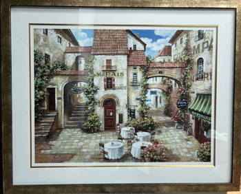
" Le MARAIS" BY ROBERT DUVAL LARGE FRAMED LITHOGRAPH SIGNED LOWER RIGHTAlice Callahan Auction House4.5(58)See Sold PriceMar 02, 2024
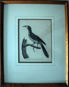
Le Valliant Crowned Hornbill Calao Couronne Rare Engraving ca1802 Framed OrnithologyLuis Porretta Fine Arts4.3(10)See Sold PriceMar 02, 2024
Proposed Sportsground Map - Haifa, Palestine - 1926Levy Auction House4.3(11)See Sold PriceFeb 27, 2024
Vintage Large Burmese Kalaga Texttile Tapestry with Crystals stones, beads, and sequins 52x75"Auction Wallstreet4.5(51)See Sold PriceMar 02, 2024
1867 Map of the Railroads of The State of New YorkRail & Road Auctions4.6(165)See Sold PriceMar 08, 2024
Map of St. Kitts and Nevis Depot de la Marine, Paris, 1758Global Auctions Company4.3(36)See Sold PriceMar 03, 2024
D'Entrecasteaux - Map of Australia (New Holland), New Zealand, and southern Asia and surroundingTrillium Antique Prints & Rare Books4.5(32)See Sold PriceFeb 24, 2024
WTC TWIN TOWER VINTAGE PRINT SIGNED ANTHONY BUTERAAntique Arena Inc.4.5(878)See Sold PriceMar 02, 2024
Pre-colonial Africa. Mountains of Kong/Moon. Caravan routes. THOMSON 1817 mapJasper524.5(9.9k)See Sold PriceFeb 28, 2024
DEATH NYC Hand Signed LARGE Print Framed 16x20in COA BANKSY HERMES PARIS NJasper524.5(9.9k)See Sold PriceFeb 28, 2024
Death NYC Large Framed 16x20in Pop Art Certified Graffiti Taylor Swift MurakamiJasper524.5(9.9k)See Sold PriceFeb 28, 2024
Death NYC Large Framed 16x20in Pop Art Original COA Theme Lichtenstein & VuittonJasper524.5(9.9k)See Sold PriceFeb 28, 2024
Death NYC Large Framed 16x20in Pop Art Original COA Theme Kaws & Murakami HermesJasper524.5(9.9k)See Sold PriceFeb 28, 2024
Death NYC Large Framed 16x20in Pop Art Original COA Theme Kaws & Yoshitomo NaraJasper524.5(9.9k)See Sold PriceFeb 28, 2024
Death NYC Large Framed 16x20in Pop Art Graffiti COA Banksy Girl MurakamiJasper524.5(9.9k)See Sold PriceFeb 28, 2024
Death NYC Large Framed 16x20in Scarce Pop Art Hand Signed COA TrumpJasper524.5(9.9k)See Sold PriceFeb 28, 2024
Death NYC Large Framed 16x20in Pop Art Original COA Theme Banksy Murakami HappyJasper524.5(9.9k)See Sold PriceFeb 28, 2024
Death NYC Large Framed 16x20in Pop Art Certified Personage XX Hirst Dots A/P *Jasper524.5(9.9k)See Sold PriceFeb 28, 2024