RARE 1930s AUTOGRAPH BOOK FEATURING RUTH & GEHRIGJohn McInnis Auctioneers,LLC4.5(505)See Sold PriceFeb 25, 2024
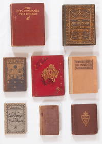
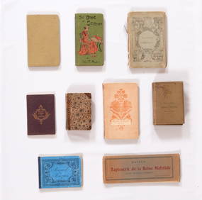
Group of Ten Books: Art of the Embroiderer, Charles Germain de Saint Aubin; Hand Weaving PatternsNazmiyal Auctions4.4(34)See Sold PriceFeb 26, 2024
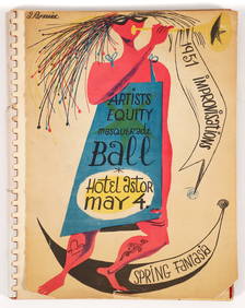
Improvisations II 55 original lithographs Artists Equity Assoc 1951Concept Art Gallery4.7(510)See Sold PriceMar 06, 2024
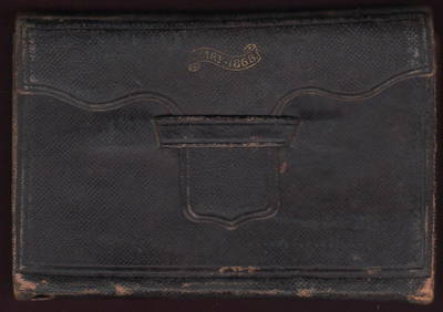
1868 Handwritten diary of Ohio canal boat operator & farmerJasper524.5(9.9k)See Sold PriceFeb 27, 2024
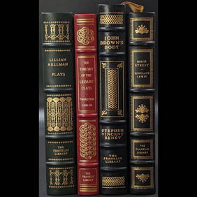
Lot Of 4 Mint Limited Edition Books From The Franklin Library.Rbfinearts4.5(578)See Sold PriceFeb 24, 2024
A Group of Eight Books: Line and Form, Walter Crane (1900); Samplers and Stitches; Designs forNazmiyal Auctions4.4(34)See Sold PriceFeb 26, 2024
First Copy of Gautier's Le Roman de la Momie - 13 Original Watercolors by George Barbier (2 VolumesTrillium Antique Prints & Rare Books4.5(32)See Sold PriceFeb 24, 2024
Group of Nine Books: Handbook of Embroidery; The Book of Stitches, Ellen T. Masters; The Lady'sNazmiyal Auctions4.4(34)See Sold PriceFeb 26, 2024
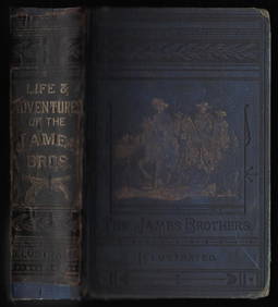
Outlaws of the Border, rare 1882 Jesse James, Younger brothersJasper524.5(9.9k)See Sold PriceFeb 27, 2024
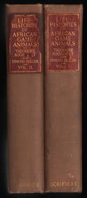
Scarce 1st ed. “Life Histories of African Game Animals?? – T. Roosevelt, E. HellerJasper524.5(9.9k)See Sold PriceFeb 27, 2024
Large lot of exhibition catalogs on CoBrA artistsConcept Art Gallery4.7(510)See Sold PriceMar 06, 2024
Sold18th C Handcolored Dutch Map Antwerp18th C Hand colored Dutch Map “Markgraafschap Des Heiligen Roomscheryk” showing Anywerp along the Schelde river. Very Good, measures 10 x 8”. Reserve: $30.00 Shipping: Domestic: Flat-rate of $5.See Sold Price
Sold(2) 18th C Double-page, hand-colored maps(2) 18th C Double-page, hand-colored etched and engraved maps taken from an atlas, inc the Champagne region of France and Antwerp, largest 16-1/2" x 20-1/2" pl, very good conditionSee Sold Price
Sold18th c Map - Italy Ducato de Urbinofrom an 18th c Atlas possibly Dutch engraved and hand colored framed & glazedSee Sold Price
SoldFramed 18th century French maps, Abraham Ortelius(lot of 2) Framed 18th century French maps, including an Abraham Ortelius (1528-1598), Poictou / Pictonum Vicinarum que Regionum Fidiss Descripto., Antwerp, C. Plantin, 1579, hand colored map of the PSee Sold Price
Sold18th c. Hand-colored map18th c. Hand-colored map- A New Map of Turkey- in Europe, divided into all its provinces, with the adjacent countries in Europe and Asia, drawn chiefly from the maps published by the Imperial AcademySee Sold Price
SoldEarly 18th C Handcolored Map Russia MoscoviaNicely handcolored map of Russia Sive Moscovia, text on verso. Fine, measures 8.5 x 6.5". Reserve: $50.00 Shipping: Domestic: Flat-rate of $5.00 to anywhere within the contiguous U.S. International: FSee Sold Price
Sold18th C. Hand-Colored Map of New EnglandAn 18th C. hand-colored engraved map of New England, Nova Scotia, New France, or Canada, with the Islands of Newfoundland, Cape Breton, St. John's, by Jacques-Nicholas Bellin. Framed under glass. MatSee Sold Price
Sold18th c. Hand-colored mapSeutter, Georg Matthaus 18th c. hand-colored map- ''Plan De La Cupitale Et Fortresse Midolebour...Augsbourg''- Town plan in color with an uncoloured general view above bottom margin, embellished withSee Sold Price
Sold(2) 1799 G. Washington Obit. & 18th C. Dutch MapTo include The Providence Journal and Town and country Advertiser, December 25, 1799, recording the death of George Washington, 4 pages, pages 2 and 3, within a mourning border, 19" H x 12" W. Also anSee Sold Price
Sold18th C Handcolored Map of Tartaria AmericaEarly Handcolored 18th C map of Tartaria that is shown across the "Strait of Aman" from America (shown in upper right corner). Text in English on verso. Fine, measures 5.75 x 4". Reserve: $80.00 ShippSee Sold Price
Sold18th c. Hand-colored map18th c. Hand-colored map- ''A New and Accurate Map of France divided into Departments with the Netherlands, 1799''- with inset Plan of Toulon, some staining and foxing throughout. 8 3/4 x 9''See Sold Price
Sold18TH C HANDCOLORED MAP - EUROPA, ASIA & AFRICAMEASURES 20"T X 23"W - CORNER MOUNTED TO CARDBOARDSee Sold Price
Early 18th C Handcolored Map Russia MoscoviaNicely handcolored map of Russia Sive Moscovia, text on verso. Fine, measures 8.5 x 6.5". Reserve: $50.00 Shipping: Domestic: Flat-rate of $5.00 to anywhere within the contiguous U.S. International: FSee Sold Price
Early 18th C Handcolored Map Russia MoscoviaNicely handcolored map of Russia Sive Moscovia, text on verso. Fine, measures 8.5 x 6.5". Reserve: $50.00 Shipping: Domestic: Flat-rate of $5.00 to anywhere within the contiguous U.S. International: FSee Sold Price
Sold18thC Hand-Colored Map, Germany, M. Seutter18th century hand-colored map, Germania Augustiniana by Matthaus Seutter, S.C.M. (German, 1678-1757), framed 28" x 31". Provenance: Del Mar, California collection.See Sold Price
Sold18TH C. HANDCOLORED ENGRAVED MAP OF AMSTERDAMDimensions: (Frame) H 15.75" x W 16", (Sight) H 9.75" x W 10.25" Condition: Some age toning and spotting.See Sold Price
Sold18th / 19th c. hand-colored map18th / 19th c. hand-colored map- ''Nuova / e corretta carta dell' / Indie Occidentali / cavata dalle migliori / autorita''. 10 5/8 x 13 1/2''See Sold Price
Sold18th C. Hand-colored Engraved Map, HaitiAn 18th century hand colored engraved map of what is now Haiti, titled " Carte De La Partie Francoise De St. Domingue", showing the area burned in the slave revolt of 1791. Engraved by Philadelphian JSee Sold Price
Sold18th C. Hand Colored Dutch EngravingCirca 1749-1770 after Gerard de Lairesse 13 1/2" (h) x 17 1/2" (l) hand colored Dutch engraving "De Destoffeerde Kamer (The furnished room)", depicts an interior scene of the Theater Keizersgracht, puSee Sold Price
Sold18th c. Hand Colored Map of Bermuda and St Kittsan original map by cartographer Emanuel Bowen 1694?-1767, detailed maps of Bermuda and St. Kitts c. 1744, with annotations noting shipwrecks, whaling, fortifications, churches etc. framed 17x19 LitchfSee Sold Price
LATE 18TH C. VERY LARGE CHART OF NORTHEAST CANADA BY DES BARRES (1721-1824), 1780, FRAMEDThomaston Place Auction Galleries4.4(393)See Sold PriceFeb 24, 2024
LARGE LATE 17TH C. DUTCH CHART OF CANADA, GREAT LAKES, NEW FRANCE, LABRADOR, HUDSON BAY, BY PIERREThomaston Place Auction Galleries4.4(393)See Sold PriceFeb 24, 2024
EARLY 18TH C. DUTCH CHART OF PACIFIC OCEAN BY FREDERIK DE WIT (1629-1706) WITH CALIFORNIA AS ANThomaston Place Auction Galleries4.4(393)See Sold PriceFeb 24, 2024
LARGE EARLY 18TH C. DUTCH CHART OF UPPER NORTH AMERICA, PIERRE MORTIER (1661-1711), FRAMEDThomaston Place Auction Galleries4.4(393)See Sold PriceFeb 24, 2024
EARLY 18TH C. MAP OF ITALY, FRAMEDThomaston Place Auction Galleries4.4(393)See Sold PriceFeb 24, 2024
18TH C. ANTIQUE MAP: FRENCH & INDIAN WAR, FRAMEDThomaston Place Auction Galleries4.4(393)See Sold PriceFeb 24, 2024
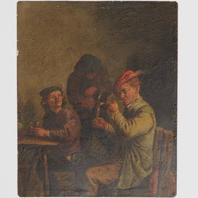
18TH C. DUTCH PAINTED OAK LETTER BOXThomaston Place Auction Galleries4.4(393)See Sold PriceFeb 24, 2024
18TH C. DUTCH BRASS OVAL ENGARVED TOBACCO BOXThomaston Place Auction Galleries4.4(393)See Sold PriceFeb 24, 2024
An early Dutch hand colored engraving map by Georg Balthasar Probst (1732-1801)Ostantix Auctions4.4(11)See Sold PriceFeb 27, 2024
17th Century Hand Colored Engraved Map of GermanyGlobal Auctions Company4.3(36)See Sold PriceMar 03, 2024
18th Century Hess Germany Hand colored Engraved MapGlobal Auctions Company4.3(36)See Sold PriceMar 03, 2024
Johann Homann Hand-Colored Map Engraving, c. 1730Auctions at Showplace4.6(740)See Sold PriceMar 17, 2024
Willem Blaeu, Etc. 17th C. Antiquarian Maps, 2Auctions at Showplace4.6(740)See Sold PriceMar 17, 2024
Two (2) Antique 18th C. Copper Engraved Framed Maps - America & EuropeMagnusson Art Group4.5(53)See Sold PriceMar 14, 2024
TWO 18th C DUTCH VESSELS & CANDLESTICKA.H. Wilkens Auctions & Appraisals4.7(396)See Sold PriceFeb 28, 2024