Rado The Original Automatic DiaStar ST Steel Gold Diamond Dial Men's WatchAuction Wallstreet4.5(52)See Sold PriceMar 02, 2024
Rado Florence, Swiss Wristwatch, Ceramic Sapphire Glass 160.3670.2Auction Wallstreet4.5(52)See Sold PriceMar 02, 2024
Brand: Rado Model Name: DiaStar Reference: 648.0413.3 Complication: Day & Date Movement: AutomaticSterling Vault Auctioneers4.3(13)See Sold PriceFeb 29, 2024
Brand: Rado Model Name: Coupole Reference: 763.3860.4 Complication: Date Movement: Automatic Box:Sterling Vault Auctioneers4.3(13)See Sold PriceFeb 29, 2024
Rado Diastar, Swiss. Mens wristwatch. 1970s/80s.Pacific Global Auction3.9(286)See Sold PriceMar 28, 2025
Rado Diastar Jubile Diamond Black Dial Black Quartz Ladies WatchGolden Gate Auctioneer4.2(284)See Sold PriceFeb 24, 2024
New Rado True Thinline R27958109 White Ceramic LadiesGolden Gate Auctioneer4.2(284)See Sold PriceFeb 24, 2024
Rare Rado DiaStar 636.0013.3 Original Automatic Gold Purple Dial Swiss Watch 36mmAuction Wallstreet4.5(52)See Sold PriceMar 02, 2024
Rado Diastar Jubile Diamond Black Dial Black Quartz Ladies WatchGolden Air Auctions4.3(267)See Sold PriceFeb 24, 2024
Reconnaissance Geologic Map of the Main Carnotite AreaTitle: Reconnaissance Geologic Map of the Main Carnotite Area of Southwestern Colorado Publication Date: c1930 Cartographer: COLORADO GEOLOGICAL SURVEY Publisher: COLORADO GEOLOGICAL SURVEY Size: 38.7See Sold Price
Reconnaissance Geologic Map of UtahMap: Reconnaissance Geologic Map of Utah Date: 1918 Cartographer: UNITED STATES GEOLOGICAL SURVEY Publisher: U.S. DEPT. INTERIOR Size (inches): 30.25x24 Scarce Large Geologic Field Map Linen MountedRoSee Sold Price
SoldGeologic Reconnaissance Map of Prince William Sound, Alaska Showing the District from the CopperPublication Date: 1909 Title: Geologic Reconnaissance Map of Prince William Sound, Alaska Showing the District from the Copper River Delta to Resurrection Bay. Cartographer: HIGGINS, D. F./U. S. GRANTSee Sold Price
Soil Map New York Dutchess County SheetTitle/Content of Map: Soil Map New York Dutchess County Sheet Date: 1907 Cartographer: MOONEY, CHARLES N./H.L. BELDEN Publisher: U.S. DEPT. AGRICULTURE Size: 39Height - 27Width Area geologic map. ColoSee Sold Price
SoldTravel Poster Brazil South American Saint Line Map Educational ProductionsOriginal vintage travel poster for Brazil featuring illustrations depicting the cotton picking process, coffee drying, steamer on Amazon, Rio de Janeiro from above, a map inset with main areas of coffSee Sold Price
SoldApollo 17 Lunar Geologic MapA vintage foldout Apollo 17 Landing Area Preliminary Geologic Map and Cross-Section measuring 25"x 33" and showing geologic features in the Taurus-Littrow landing site. Toned with age, but otherwise gSee Sold Price
SoldApollo 17 Lunar Geologic MapA vintage foldout Apollo 17 Landing Area Preliminary Geologic Map and Cross-Section measuring 25"x 33" and showing geologic features in the Taurus-Littrow landing site. Toned with age, but otherwise gSee Sold Price
SoldPhiladelphia Area Property AtlasAtlas showing maps of the Main Line areas of Downingtown through Devon.See Sold Price
Reconnaissance Map of Mt. McKinley, Alaska (121152)This is a reconnaissance map of the Mt. McKinley area of Alaska made by the U.S. Army in 1904, scale is 625, by Brooks and Reaburn in 1902 printed by Julius Bien.. 25 in. X 35 in. in very good conditiSee Sold Price
SoldReconnaissance Map of Mt. McKinley, Alaska (121152)This is a reconnaissance map of the Mt. McKinley area of Alaska made by the U.S. Army in 1904, scale is 625, by Brooks and Reaburn in 1902 printed by Julius Bien.. 25 in. X 35 in. in very good conditiSee Sold Price
1794 Wilkinson Map of Central Germany, Rhine, Moselle and Main River Area s-- A Map of the CirclesTitle: 1794 Wilkinson Map of Central Germany, Rhine, Moselle and Main River Area s-- A Map of the Circles of The Upper Rhine, Lower Rhine & Franconia, Drawn from the Best Authorities Cartographer: R WSee Sold Price
1794 Wilkinson Map of Central Germany, Rhine, Moselle and Main River Area s-- A Map of the CirclesTitle: 1794 Wilkinson Map of Central Germany, Rhine, Moselle and Main River Area s-- A Map of the Circles of The Upper Rhine, Lower Rhine & Franconia, Drawn from the Best Authorities Cartographer: R WSee Sold Price
1794 Wilkinson Map of Central Germany, Rhine, MoselleTitle: 1794 Wilkinson Map of Central Germany, Rhine, Moselle and Main River Area s-- A Map of the Circles of The Upper Rhine, Lower Rhine & Franconia, Drawn from the Best Authorities Cartographer: R WSee Sold Price
1794 Wilkinson Map of Central Germany, Rhine, MoselleTitle: 1794 Wilkinson Map of Central Germany, Rhine, Moselle and Main River Area s-- A Map of the Circles of The Upper Rhine, Lower Rhine & Franconia, Drawn from the Best Authorities Cartographer: R WSee Sold Price
Tintic Special USGS Folio (109502)Folio of the area of the Tintic, List of Sheets, Historical Geology, Library Edition engraved and Printed by the USGS, George W. Stose, Editor of Geologic Maps, S.J. Kubel, Chief Engraver, 1900. TheeSee Sold Price
Tintic Special USGS Folio 109502Folio of the area of the Tintic, List of Sheets, Historical Geology, Library Edition engraved and Printed by the USGS, George W. Stose, Editor of Geologic Maps, S.J. Kubel, Chief Engraver, 1900. TheeSee Sold Price
SoldTintic Special USGS Folio (109502)Folio of the area of the Tintic, List of Sheets, Historical Geology, Library Edition engraved and Printed by the USGS, George W. Stose, Editor of Geologic Maps, S.J. Kubel, Chief Engraver, 1900. TheeSee Sold Price
Sold19th Century Silk Map of Washington D.C. Area.Measuring 32" x 39" framed is a large map drawn on cloth of the area within and around Washington, D.C. Map shows main roads and towns as far out as Front Royal and Winchester, Va.See Sold Price
Reconnaissance of Romerly Marshes GeorgiaTitle/Content of Map: Reconnaissance of Romerly Marshes Georgia Cartographer: WILLIAMS, L. D. | A.W. LONGFELLOW Date: 1855 Publisher: U.S.C.S. Size: 16.1Height - 28.5Width A marsh area off the WilmingSee Sold Price
Ancient map of the Rhineland, Jansson/Mercator 1628Nearly 400-year-old map of the geographical area between the rivers Rhine, Main and Ruhr. Leodiensis Diocesis, Cleve et Muers from an edition of Mercator’s Atlas Minor. Jocodus Hondius created tSee Sold Price
SoldU.S. Coast Survey 1853 Map of St. Georges Sound,"Preliminary Reconnaissance of the Middle or Main, and West Entrances to St. Georges Sound Florida" Electrotype Map Published 1843-65, Washington for "Report of the Superintendent of the U.S. Coast SuSee Sold Price
MOUNT VERNON Vintage Black and White MapThis MOUNT VERNON vintage black and white map depicts the farm lands of the area. The map is titled PLAN DU DOMAINE DE MONT VERNON D ASPRES US DESSIN ORIGINAL DE LA MAIN DE WASHINGTON. PROVENANCE: ThiSee Sold Price
SoldAviation 1950's Pilot Bail-Out Maps(23 x 31") Lot of two different multicolor silk pilot bail-out maps that would have been carried by Cold War reconnaissance pilots that depict 1) the Bucuresti area adjacent to the U.S.S.R on the obveSee Sold Price
Pacific Area in World War II 1941-1945 Wesley SocialPublication Date: 1961 Title: Pacific Area in World War II 1941-1945 Wesley Social Studies [Series] WA34 Cartographer: R. Baxter Blair Publisher: Denoyer-Geppert Co. Height: 28.25 Width: 41.5 Main topSee Sold Price
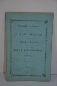
Central Railroad of New Jersey 13th Annual Report-January 1, 1860JM Hobby Supply and Railroad Artifact Auctions4.4(127)See Sold PriceFeb 24, 2024
New York Central RR The Adirondacks Brochure 1916-1917JM Hobby Supply and Railroad Artifact Auctions4.4(127)See Sold PriceFeb 24, 2024
Rock Island RR Iowa and Minnesota Lakes Country Brochure-1926JM Hobby Supply and Railroad Artifact Auctions4.4(127)See Sold PriceFeb 24, 2024
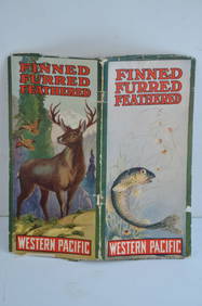
Western Pacific RR Finned Furred Feathered Brochure-1912JM Hobby Supply and Railroad Artifact Auctions4.4(127)See Sold PriceFeb 24, 2024
Delaware Lackawanna and Western RR July 15, 1889 Public TimetableJM Hobby Supply and Railroad Artifact Auctions4.4(127)See Sold PriceFeb 24, 2024
OUTSTANDING SUNOCO MOTOR OILS & DISNEY FRAMED DISPLAY W/ INK BLOTTERS.Dan Morphy Auctions4.2(1.3k)See Sold PriceFeb 24, 2024
1885 CIVIL WAR 1ed Famous Memoirs US Grant Sheridan Sherman 6v RARE LOT MapsSchilb Antiquarian Rare Books4.8(431)See Sold PriceMar 10, 2024
Jerusalem Map for British Soldiers in Palestine - WW2Levy Auction House4.3(11)See Sold PriceFeb 27, 2024
Group of Ten Railroad Photographs, Maps, and Prints - New Jersey, Long Island, and New YorkRail & Road Auctions4.6(165)See Sold PriceMar 07, 2024
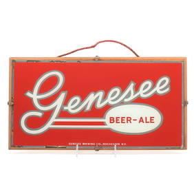
Genesee Beer - Ale 1940s Price Bros Reverse Painted Sign SHARPMorean Auctions4.5(33)See Sold PriceFeb 25, 2024
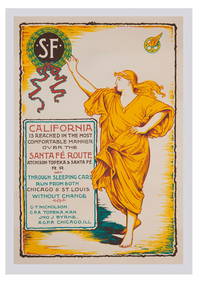
A Rare Disneyland Santa Fe Railroad Exhibit Poster.Van Eaton Galleries4.6(103)See Sold PriceMar 02, 2024
An Original Sheet of Main Street Building Plans.Van Eaton Galleries4.6(103)See Sold PriceMar 02, 2024
An Original Sheet of Main Street Building Plans.Van Eaton Galleries4.6(103)See Sold PriceMar 02, 2024
PAIR CHINESE FAMILLE ROSE PORCELAIN TABLE LANTERNSA.H. Wilkens Auctions & Appraisals4.7(400)See Sold PriceFeb 29, 2024