Nautica Men's Stainless Steel Quartz Watch works great needs bandAnnzstiques Auction House4.4(613)See Sold PriceFeb 25, 2024
Small Shells Trinket Box NauticaRapid Estate Liquidators and Auction Gallery4.5(1.1k)See Sold PriceFeb 28, 2024
SoldUNITED STATES COAST SURVEY NAUTICAL DRAFTING TOOL inCa early to mid. 20th century. Brass and metal. Marked USCG No. 14. Measures 25 inches long.See Sold Price
Antique Nautical Chart of San Francisco Harbor, 1885Map: 1885 British Admiralty Chart of San Francisco Harbor -- North America; West Coast; San Francisco Harbour from United States Coast Survey 1877 Date Printed: 1885, London Cartographer: British AdmiSee Sold Price
Sold60 nautical maps: US Coast Survey, [ca. 1858].[Coast Survey]. 60 maps from a United States Coast Survey annual report, most maps dated 1857. [Wash: GPO, c.1858]. 4to. Includes: ++ 3 copies of New England's coast (Map 1). ++ Seacoast of Part of AlSee Sold Price
SoldAlbemarle Sound Chart, North CarolinaFramed nautical chart by the United States Coast Survey of Albemarle Sound, North Carolina. From the Atlantic Ocean to the Pasquotank River. Dated 1876. Dimensions: 36" L x 33" H Weight: 14lbs *This lSee Sold Price
THREE LONG ISLAND SOUND CHARTSThree original framed charts showing the coast of Long Island Sound by THE UNITED STATES COAST SURVEY. Showing sections of Long Island, the coast of Connecticut, up to Rhode Island. Dimensions: 23 talSee Sold Price
Sold82 maps Coast Survey reports 1856-1862[Coast Survey]. 82 Maps from 3 United States Coast Survey reports for 1856, 1860, and 1862. [Wash: GPO, 1857, 1861, 1863]. Detailed nautical folding maps, with soundings, lighthouses, and other informSee Sold Price
Albemarle Sound Chart, CarolinaFramed nautical chart by the United States Coast Survey of Albemarle Sound, North Carolina. From the Atlantic Ocean to the Pasquotank River. Dated 1876. Dimensions: 36" L x 33" H Weight: 14lbsSee Sold Price
SoldFramed Corpus Christi Bay Nautical ChartCorpus Christi nautical chart, 4th ed., dated "May / 10" marked by the National Oceanic and Atmospheric Administration (NOAA), United States Coast and Geodetic Survey height 39 in. x width 49See Sold Price
Western Coast of the United States Map, 1853Western Coast of the United States, U. S. Coast Survey, 1853. 14.5 x 17.75 inches. Antique nautical chart of the Western Coast of the United States, from Gray’s Harbor to the Entrance of Admiralty ISee Sold Price
Sold5Pcs Antique Maps US COAST AND GEODETIC SURVEY MAPS OFDetails: This lot includes the following group of five antique nautical maps from the United States Coast and Geodetic Survey:Hudson River From Poughkeepsie to Hudson City New York, 1878; East River,See Sold Price
NOAA Nautical Chart/Ocean Survey Chesapeake BayNOAA formally C. & G.S.,United States - East Coast Maryland - Virginia "CHESAPEAKE BAY SMITH POINT TO COVE POINT", stamped upper center 1st Ed., July 1913 D-1954 -8418. Stamped lower right 12230 (formSee Sold Price
SoldA SURVEY OF THE COAST OF THE UNITED STATES, A HANDA SURVEY OF THE COAST OF THE UNITED STATES, A HAND COLORED NAUTICAL CHART, "Preliminary Chart of the Sea Coast of Texas in the Vicinity of Galveston," 1856, an early nautical chart of Galveston Bay anSee Sold Price
SoldA SURVEY OF THE COAST OF THE UNITED STATES, A HANDA SURVEY OF THE COAST OF THE UNITED STATES, A HAND COLORED NAUTICAL CHART, "Galveston Entrance, Texas," 1856, a detailed chart of the Galveston, Texas, including the eastern tip of Galveston Island, PSee Sold Price
SoldFRAMED NAUTICAL CHART - NEW YORK BAY AND HARBOR"Map of the New York Bay and Harbor and Environs", from the Survey of the Coast of the United States, with sailing directions, published in 1845, under the direction of F. R. Hassler, Superintendent,See Sold Price
SoldWestern Coast of U. S., 1854 Coast SurveyLarge, impressive nautical chart of the Reconnaisance of the Western Coast of the United States (Middle Sheet) from San Francisco to Umpquah River. Coastal chart of the western coast with twelve vigneSee Sold Price
SoldWestern Coast of U. S., 1853 Coast SurveyHand-colored, antique nautical chart of the Western Coast of the United States, from Gray’s Harbor to the Entrance of Admiralty Inlet. Coastal chart of the northwestern corner of Washington, Cape FlSee Sold Price
Western Coast of U. S., 1853 Coast SurveyReserve Reduced! "Hand-colored, antique nautical chart of the Western Coast of the United States, from Gray’s Harbor to the Entrance of Admiralty Inlet. Coastal chart of the northwestern corner of WSee Sold Price
Western Coast of U. S., 1854 Coast SurveyReserve Reduced! Large, impressive nautical chart of the Reconnaisance of the Western Coast of the United States (Middle Sheet) from San Francisco to Umpquah River. Coastal chart of the western coastSee Sold Price
SoldUNITED STATES COAST SURVEY, CITY OF SAN FRANCISCO ANDThis early plan of the city of San Francisco covers the region from North Point to Mission de Delores and to Point San Quentin. 25 1/2 x 17 3/4 inches Provenance: A Salt Lake City estate of a prominenSee Sold Price
SoldUnited States Coast Survey Medal (119779)Provenance: Lot 1720 of the Kessler- Spangenberger Public Auction Sale, April 28-29, 1981, New York City. Obv.: For / Gallantry / And Humanity / Dec. 1846; Rev.: The / Treasury Department / Of The UniSee Sold Price
SoldMaps and Charts of the United States Coast Survey,Heading: (U.S. Coast Survey) Author: Bache, A.D. Title: Maps and Charts of the United States Coast Survey Place Published: [Washington, D.C.] Publisher: Date Published: 1854 DescriptionSee Sold Price
UNITED STATES COAST SURVEY - CATALINA HARBOR,United States Coast Survey - Catalina Harbor, California, 1852 - Giclée On Canvas - 20 3/8 X 30 In. - A Giclée Print Is The Highest Quality Print Available Today. Because There Is No Visible Dot ScrSee Sold Price
UNITED STATES COAST SURVEY - ENTRANCE TO SAN FRANCISCOUnited States Coast Survey - Entrance To San Francisco Bay California, 1859 - 30 X 18 1/4 In. - This Giclée Print Is Gallery Stretched And Ready To Hang Or Lean Against A Wall, Or Display On An EaselSee Sold Price
UNITED STATES COAST SURVEY - MAP OF NEW YORK BAY ANDUnited States Coast Survey - Map Of New York Bay And Harbor And The Environs, 1844 - 34 1/2 X 36 In. - Giclée Print - Gallery Stretched - Ready to hang.See Sold Price
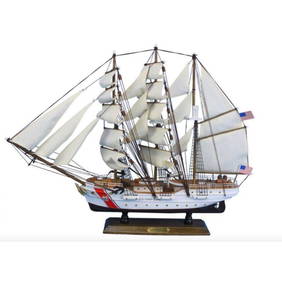
United States Coast Guard USCG Eagle Tall Model Ship 24"Weatherham Estate Treasures3.9(157)See Sold PriceMar 07, 2024
24" United States Coast Guard USCG Eagle Tall Model ShipWeatherham Estate Treasures3.9(157)See Sold PriceMar 07, 2024
24" United States Coast Guard USCG Eagle Tall Model ShipWeatherham Estate Treasures3.9(157)See Sold PriceMar 14, 2024
United States Coast Guard USCG Eagle Tall Model Ship 24"Weatherham Estate Treasures3.9(157)See Sold PriceMar 21, 2024
Wooden United States Coast Guard USCG Eagle Model Ship 15"Weatherham Estate Treasures3.9(157)See Sold PriceMar 21, 2024
CHARTS: United States - East Coast New Jersey/ PASSAIC AND HACKENSACK RIVERSChurchill Galleries3.7(213)See Sold PriceFeb 26, 2024
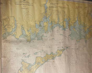
CHART: UNITED STATES - EAST COAST/ RHODE ISLAND - CONNECTICUT - NEW YORK/ Fishers IslandChurchill Galleries3.7(213)See Sold PriceFeb 26, 2024
CHART: UNITED STATES - EAST COAST MASSACHUSETTS/ HYANNIS HARBORAND VICINITYChurchill Galleries3.7(213)See Sold PriceFeb 26, 2024
Chart: United States- East Coast/ NORTH CAROLINA/ RIVER INLET TO CAPE FEAR.Churchill Galleries3.7(213)See Sold PriceFeb 26, 2024
CHART: UNITED STATES - EAST COAST NEW YORK/ HUDSON RIVER/ POUGHKEEPSIE TO HUDSONChurchill Galleries3.7(213)See Sold PriceFeb 26, 2024
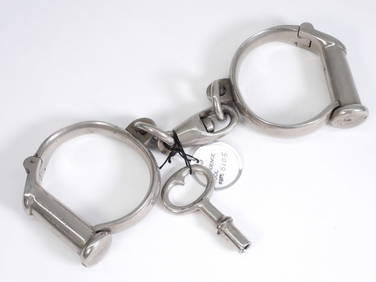
Fine Providence Tool Co. Rhode Island HandcuffsBruneau & Co. Auctioneers4.5(491)See Sold PriceMar 18, 2024


![60 nautical maps: US Coast Survey, [ca. 1858]. (1 of 3)](https://p1.liveauctioneers.com/179/14187/4432324_1_x.jpg?height=282&quality=70&version=1194393062)