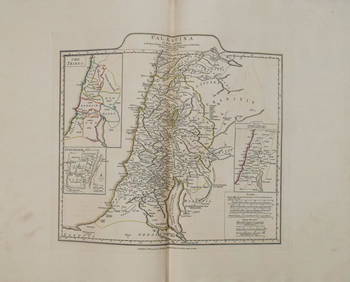
SoldTallis, John (Pub) 1852 Map. Ancient PalestineSteel Engraved Map with Original Outline Hand Color Published 1852-56 by John Tallis, London for "The Universal Pronouncing Dictionary" by Thomas Wright. Drawn & Engraved by John Rapkin. Centre fold aSee Sold Price
1767 d'Anville Map of Ancient Palestine -- PalaestinaTitle/Content of Map: 1767 d'Anville Map of Ancient Palestine -- Palaestina by Mons. d'Anville of the Royal Academy … Date: 1767, London Cartographer: J d'Anville Size: 14.8 x 16.8 in. This is a nicSee Sold Price
Chapman & Hall / SDUK: Map of Ancient Palestine, 1843Palestine in the time of our Saviour The fascinating map of ancient Palestine from the SDUK atlas, with "every known ancient site inserted," a number key to the tribal territories, and an inset plan oSee Sold Price
Sold1828 Map of Ancient PalestineAuthor: Hall Title: 1828 Map of Ancient Palestine Medium: Ink on Paper Dimensions: 8.5"X10.5" Map of Ancient Palestine dated 1828. Part of Butler's Antique World Atlas. Drawn and engraved by Sydney HaSee Sold Price
Sold1767 d'Anville Map of Ancient Palestine -- PalaestinaTitle/Content of Map: 1767 d'Anville Map of Ancient Palestine -- Palaestina by Mons. d'Anville of the Royal Academy … Date: 1767, London Cartographer: J d'AnvilleSize: 14.8 x 16.8 in. This is a niceSee Sold Price
SoldHomann Map of Ancient Palestine,Homann Map of Ancient Palestine, "Carte de la Tere Sainte divisee selon les Donze Tribus D' Israel...", cartography by Johann Cristoph Harenberg, published by the "Heirs of Homann", Germany, 1750, hanSee Sold Price
MAP OF ANCIENT PALESTINEMAP OF ANCIENT PALESTINE Circa 1836. London. Published by Henry Teesdale & Co., 302 High Holborn. Drawn and engraved by J. Dower Pentonville. Engraving with Hand Coloring. Sight measuring 18 1/4" by 1See Sold Price
1767 d'Anville Map of Ancient Palestine -- PalaestinaTitle/Content of Map: 1767 d'Anville Map of Ancient Palestine -- Palaestina by Mons. d'Anville of the Royal Academy … Date: 1767, London Cartographer: J d'Anville Size: 14.8 x 16.8 in. This is a nicSee Sold Price
1801 Map of Ancient PalestineAuthor: Hall Title: 1801 Map of Ancient Palestine Medium: Ink on Paper Dimensions: 8.5"X11" Map of Ancient Palestine dated 1801. Part of the Atlas of Ancient Geography. Engraved by S. Hall. Curated bySee Sold Price
1828 Map of Ancient PalestineAuthor: Hall Title: 1828 Map of Ancient Palestine Medium: Ink on Paper Dimensions: 8.5"X10.5" Map of Ancient Palestine dated 1828. Part of Butler's Antique World Atlas. Drawn and engraved by Sydney HaSee Sold Price
1801 Map of Ancient PalestineAuthor: Hall Title: 1801 Map of Ancient Palestine Medium: Ink on Paper Dimensions: 8.5"X11" Description: Map of Ancient Palestine dated 1801. Part of the Atlas of Ancient Geography. Engraved by S. HalSee Sold Price
Stanford Map of Ancient PalestineSTANFORD, Edward (1827-1904). Ancient Palestine. Lithograph with original hand color from the Society for the Diffusion of Useful Knowledge. London: Edward Stanford, 1857-1870. 17 1/4" x 13 3/4" sheetSee Sold Price
1767 d'Anville Map of Ancient Palestine -- PalaestinaReserve Reduced! Title/Content of Map: 1767 d'Anville Map of Ancient Palestine -- Palaestina by Mons. d'Anville of the Royal Academy … Date: 1767, London Cartographer: J d'Anville Size: 14.8 x 16.8See Sold Price
1767 d'Anville Map of Ancient Palestine -- Palaestina by Mons. d'Anville of the Royal Academy …Title: 1767 d'Anville Map of Ancient Palestine -- Palaestina by Mons. d'Anville of the Royal Academy … Cartographer: J d'Anville Year / Place: 1767, London Map Dimension (in.): 26.4 x 21.7 in. TSee Sold Price
1767 d'Anville Map of Ancient Palestine -- Palaestina by Mons. d'Anville of the Royal Academy …Title: 1767 d'Anville Map of Ancient Palestine -- Palaestina by Mons. d'Anville of the Royal Academy … Cartographer: J d'Anville Year / Place: 1767, London Map Dimension (in.): 26.4 x 21.7 in. TSee Sold Price
1767 d'Anville Map of Ancient Palestine -- PalaestinaTitle/Content of Map: 1767 d'Anville Map of Ancient Palestine -- Palaestina by Mons. d'Anville of the Royal Academy … Date: 1767, London Cartographer: J d'Anville Size: 14.8 x 16.8 in. This is a nicSee Sold Price
SoldCarey & Lea: Map of Palestina Antiqua, 1832Palestina Antiqua with inset of Jerusalem. Pub. 1832 by Carey & Lea. 7 x 9. Map of ancient Palestine with hand-colored outlines to delineate areas. Extremely light foxing in a few areas. Small repaireSee Sold Price
SoldFive framed items including Poussin print - note onFive framed items including Poussin print - note on reverse identifies date as 1805, large folio architectural engraving pencil signed illegibly 1965, map of Ancient Palestine - hand colored - engraveSee Sold Price
SoldSDUK: Palestine “In the Time of Our Saviour”The fascinating map of ancient Palestine from the SDUK atlas, with "every known ancient site inserted," a number key to the tribal territories, and an inset plan of ancient Jerusalem. W. Hughes, ChapmSee Sold Price
1801 Map of Antique PalestineAuthor: Hall Title: 1801 Map of Antique Palestine Medium: Ink on Paper Dimensions: 8.5"X11" Map of Ancient Palestine dated 1801. Part of the Atlas of Ancient Geography. Engraved by S. Hall. Curated bySee Sold Price
Alexis Hubert Jaillot (1632-1712): Map of Holy LandAlexis Hubert Jaillot: Map of Holy Land, engraving, map showing Ancient Palestine, Judea and the Holy Land from “Atlas Nouveau,” published by Jaillot in Paris, 1696, edited by Pierre Mortier. AlexSee Sold Price
Chapman & Hall/SDUK: Palestine in our Saviour’s TimeThe fascinating map of ancient Palestine from the SDUK atlas, with "every known ancient site inserted," a number key to the tribal territories, and an inset plan of ancient Jerusalem.Cartographer: ChaSee Sold Price
SDUK: Palestine “In the Time of Our Saviour”Reserve Reduced! The fascinating map of ancient Palestine from the SDUK atlas, with "every known ancient site inserted," a number key to the tribal territories, and an inset plan of ancient Jerusalem.See Sold Price
1801 Map of PalestineAuthor: Hall Title: 1801 Map of Palestine Medium: Ink on Paper Dimensions: 8.5"X11" Map of Ancient Palestine dated 1801. Part of the Atlas of Ancient Geography. Engraved by S. Hall. Curated by SamuelSee Sold Price
Jerusalem Map for British Soldiers in Palestine - WW2Levy Auction House4.3(11)See Sold PriceFeb 27, 2024
Proposed Sportsground Map - Haifa, Palestine - 1926Levy Auction House4.3(11)See Sold PriceFeb 27, 2024
Caravan Routes in Palestine Linen Map - Germany, 1881Levy Auction House4.3(11)See Sold PriceFeb 27, 2024
SUB-SAHARAN AFRICA. 'Ancienne Ethiopie'. Ancient Ethiopia. MALLET 1683 old mapJasper524.5(9.8k)See Sold PriceFeb 28, 2024
Afrique Ancienne. Ancient North Africa. MALTE-BRUN c1871 old antique map chartJasper524.5(9.8k)See Sold PriceFeb 28, 2024
Georg Bockler Map of Ancient Jerulsaem EtchingAuctions at Showplace4.6(731)See Sold PriceApr 07, 2024
Ancient Chinese landscape map of Ma Yuan on silkJapan Ancient Art Co. LTD4.4(39)See Sold PriceFeb 28, 2024
Chinese ancient Zhang Ji character story map on silk scrollJapan Ancient Art Co. LTD4.4(39)See Sold PriceFeb 28, 2024
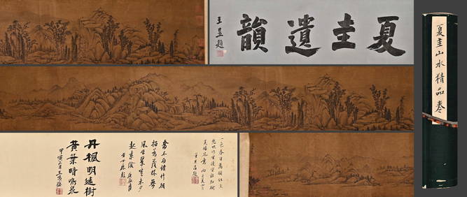
Chinese ancient Xiagui mountain water map on silk hand scrollJapan Ancient Art Co. LTD4.4(39)See Sold PriceFeb 28, 2024
Ancient Chinese Xu Yang character story map on silk scrollJapan Ancient Art Co. LTD4.4(39)See Sold PriceFeb 28, 2024
Ancient Chinese Lizhang mountain village seclusion map on silk scrollJapan Ancient Art Co. LTD4.4(39)See Sold PriceFeb 28, 2024
Ancient Chinese landscape map of Li Zhang on silkJapan Ancient Art Co. LTD4.4(39)See Sold PriceFeb 28, 2024
Ancient Chinese Li Zhaodao landscape map on silkJapan Ancient Art Co. LTD4.4(39)See Sold PriceFeb 28, 2024
Chinese ancient Xiagui mountain water map on silk hand scrollJapan Ancient Art Co. LTD4.4(39)See Sold PriceFeb 28, 2024
Chinese ancient Zhu Rui landscape map on silk hand scrollJapan Ancient Art Co. LTD4.4(39)See Sold PriceFeb 28, 2024
Chinese ancient Han Gan character story map on silk scrollJapan Ancient Art Co. LTD4.4(39)See Sold PriceFeb 28, 2024
Rees & Macpherson 1820 Lot of 6 Ancient Geography MapsAlbion Auctions4.6(341)See Sold PriceMar 01, 2024