Vintage Ca. 1940's International Panel Delivery Truck Converted into Stationary Food Truck, WasSwisher Bros. Auction LLC4.4(241)See Sold PriceFeb 25, 2024
Thomas Hart Benton; 20thC. American Regionalist Oil SignedMid-Hudson Auction Galleries4.4(468)See Sold PriceFeb 24, 2024
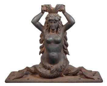
CAST IRON SHIP'S WHEEL BRACKET HELM IN THE FORM OF A MERMAID Last Quarter of the 19th/First QuarterEldred's4.7(409)See Sold PriceFeb 27, 2024
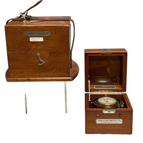
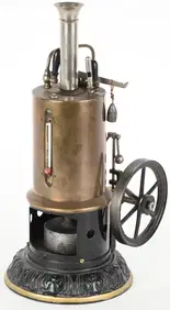
Hamilton Chronometer Model 22 Ship Clock 8630Premier Auction Galleries4.3(329)See Sold PriceMar 09, 2024
Art Deco Collectible Uranium Glass VICTOIRE Car Mascot Hood Ornament 1930' H.Hoffmann SculptureArt Glass Store4.5(60)See Sold PriceMar 03, 2024
Graphic Long Life 1 Gallon Motor Oil CanCheck the Oil Promotions, LLC4.6(275)See Sold PriceMar 03, 2024
Art Deco 1930' Collectible Glass Car Mascot ' Spirit Of The Wind ' H.Hoffmann by LaliqueArt Glass Store4.5(60)See Sold PriceMar 03, 2024
ATLAS of ANTIENT GEOGRAPHY by SAMUEL BUTLER 1843John McInnis Auctioneers,LLC4.6(502)See Sold PriceFeb 24, 2024
18TH C. ANTIQUE MAP: FRENCH & INDIAN WAR, FRAMEDThomaston Place Auction Galleries4.4(386)See Sold PriceFeb 24, 2024
Rand McNally Railroad Map Cabinet w/ 21 Railroad MapsRail & Road Auctions4.6(165)See Sold PriceMar 08, 2024
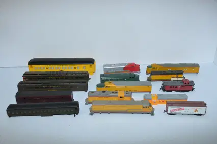
Huge Tote of HO Scale Steam and Diesel Train Locomotives, Cars and PartsJM Hobby Supply and Railroad Artifact Auctions4.4(126)See Sold PriceFeb 25, 2024
SoldHindoostan, Farther India, China, & Tibet MapHindoostan, Farther India, China, and Tibet, 15.25 x 12.25 in, 1864, S. Augustus Mitchell Please note that this lot has a confidential reserve. When you leave a bid in advance of the auction, submit ySee Sold Price
SoldMap of Hindoostan, Farther India, China, and Tibet 1861Title/Content of Map: Map of Hindoostan, Farther India, China, and Tibet. Cartographer: WILLIAMS, W. Size: 11.1X13.75 Map 72 from Mitchell's New General Atlas. Polar projection. Southeast Asia calledSee Sold Price
SoldThomson: Map of Hindoostan, 1814Map: Hindoostan Cartographer: Thomson Place & Date: Edinburgh / 1814/1817 Size: 24 1/8" x 22 5/8" Condition: light overprinting and minor spotting The magnificent India map Thomson's influential New GSee Sold Price
SoldJohnson: Antique Map of Hindoostan & Farther India 1868Map: Johnson's Hindoostan and farther India Date Printed: 1868 Cartographer: A. J. Johnson Material/Medium: Paper Size: 26 1/2" x 18" Condition: Very Good. Minor tear on upper right corner. Does not aSee Sold Price
SoldMap of Hindoostan and China. 1839.Print of steel engraving. Author unknown.Engraved by G. Boynton.From „The second book of History, including The modern history of Europe, Africa, and Asia. Illustrated by engravings and sixteen mapsSee Sold Price
SoldIndia.- Wyld (James) Hind, Hindoostan, or India By L.S.India.- Wyld (James) Hind, Hindoostan, or India By L.S. de la Rochette ..., detailed map of the Indian continent including Sri Lanka and the Maldive Islands, with jungle vignette featuring an elephantSee Sold Price
SoldPennant's View of HindoostanHeading: (India) Author: [Pennant, Thomas] Title: The View of Hindoostan Place Published: London Publisher:Henry Hughs Date Published: 1798 Description: 2 volumes. [2], xvi,See Sold Price
SoldMap Of HindoostanMap Of Hindoostan Description: Well preserved map of Hindoostan. Measurement approximate: 10’ x 12” Please note that this lot has a confidential reserve. When you leave a bid in advance of the aucSee Sold Price
19th C Map of HindoostanMap: Hindoostan (India) Date: 19th century Map Size: 10 x 12 inches Frame Size: 18 x 20 inches Hindoostan (or Hindustan) is a common geographic term for the northern/northwestern Indian subcontinent.See Sold Price
Sold1812 Darton Map of India and Pakistan - HindoostanTitle/Content of Map: 1812 Darton Map of India and Pakistan - Hindoostan Date: 1812, London Cartographer: W Darton Size: 9.3 X 11.2 in. This is a very nice map of India with plenty of detail as to rivSee Sold Price
Map of Hindoostan, 1830Map: Hindoostan Maker: Longman, Rees, Orme, Brown and Green, Sydney Hall Date: 1830 Size: Folio, 20 inches high x 16 inches wide Polar projection Sydney Hall (1818-1860) worked as a map maker at a timSee Sold Price
SoldSidney Hall: Map of Hindoostan, 1830Map: Hindoostan. Maker: Longman, Rees, Orme, Brown and Green, Hall, Sidney Publication Date: 1830 Publisher: Longman, Rees, Orme, Brown and Green Size: Folio – 20.00 H x 16.00 W Inches Polar projectSee Sold Price
1829 Hall Map of India -- HindoostanTitle/Content of Map: 1829 Hall Map of India -- Hindoostan Date: 1829, London Cartographer: S Hall Size: 9.5 X 7.3 in. This is avery nice somewhattl smaller map of India. Plenty of detail as to topogrSee Sold Price
Sold1802 Arrowsmith Map of India -- HindoostanTitle: 1802 Arrowsmith Map of India -- Hindoostan Date: 1802, London Cartographer: Aroowsmith Size: 9.8 X 8 in. Additional Information: This is a nice map of India, Sri Lanka, Bangladesh, Bhutan, muchSee Sold Price
SoldJohn Thomson HINDOOSTAN AND ISLE OF CEYLON MAP 1817Details: John Thomson HINDOOSTAN AND ISLE OF CEYLON MAP 1817 Antique New General Atlas Hand Colored India J & G Menzies Edinburgh Tibet Persia S & C WiseThis lot consists of a map of "Hindoostan (witSee Sold Price
SoldIndia.- Rennell (James) Memoir of a Map of Hindoostan;India.- Rennell (James) Memoir of a Map of Hindoostan; or the Mogul's Empire, second edition, 5 engraved maps, 4 folding, the large map in 2 parts, hand-coloured in outline and with large vignette, moSee Sold Price
Sold[TRAVELS] Rennell, Memoir of a map of HindoostanRennell James, Memoir of a map of Hindoostan or the Moghul Empire... London: M. Brown, 1788. In-4° (mm 260x210). Pagine [1], 1 bianca, CXL, [1], 1 bianca, 295, 1 bianca, [25], 1 bianca + 6 taSee Sold Price
SoldHindoostan Or India.Title: Hindoostan Or India. Publication Date: 1796 ca. Cartographer: WALKER, JOHN Publisher: J. JOHNSON, etc. Size: 7.3X8.25 "Engraved for Walker's Geography." Probably from the fifth edition of his USee Sold Price
SoldHindoostan.Title: Hindoostan. Publication Date: 1834 Cartographer: G. Boynton Publisher: Samuel WalkerSize: 9.3Height - 7.75Width Attractive map from System of Geography by M. Malte Brun containing a descriptionSee Sold Price
SoldHindoostanTitle: Hindoostan Date: 1822 Cartographer: JOCELYN, N. & S.S. (SC.) Publisher: HOWE & SPAULDING Size: 9.6Height - 7.8Width From Sydney E. Morse and Jedidiah Morse's A new universal atlas of the world;See Sold Price
Sold1814 Findlay Map of India and Sri Lanka -- HindoostanTitle/Content of Map: 1814 Findlay Map of India and Sri Lanka -- Hindoostan Date: 1814, London Cartographer: A Findlay Size: 10 x 7.4 in. This is a very nice map of India and Ceylon (Sri Lanka). The pSee Sold Price
SoldEncyclopaedia Perthensis 1816 Map of India HindoostanCopper Engraved Map Published 1816 by John Brown, Edinburgh for "Encyclopaedia Perthensis; Or Universal Dictionary of the Arts, Sciences, Literature, &c" by John Brown. Engraved by Kirkwood & Sons. FoSee Sold Price
SoldHindoostan, India, Nepal, Pakistan, Ceylon, 1839Original engraving from "New General Atlas, being a Collection of Maps of the World & Various Quarters" published by Allan Bell & Co., in London, 1839. Dimensions: 14.25 x 20 inches.See Sold Price
SoldHindoostanTitle: Hindoostan Artist: Anthony Finley Medium: Engraving Dimensions: 11 x 8 1/2 Description: 1830 map of Indian subcontinent Reserve: $40.00 Shipping: Domestic: Flat-rate of $5.00 to anywhere wSee Sold Price
A group of seven 18th-century prints showing people and religions of IndiaIndigo Art AuctionsSee Sold PriceMar 08, 2024


![[TRAVELS] Rennell, Memoir of a map of Hindoostan (1 of 2)](https://p1.liveauctioneers.com/1306/165899/83732170_1_x.jpg?height=282&quality=70&version=1586937270)


