Marc Chagall-Limited Edition -Paris Opera Ceiling after ChagallArt Legacy Auctions4.5(219)See Sold PriceFeb 24, 2024
Salvador Dali Pantagruel Limited Edition Lithograph Hand signed and numberedArt Legacy Auctions4.5(219)See Sold PriceFeb 24, 2024
Pablo Picasso Bouquet of Peace Collection Domaine Picasso Limited Edition on paper.Art Legacy Auctions4.5(219)See Sold PriceFeb 24, 2024
A RARE MAXFIELD PARRISH JACK AND THE BEANSTALK PRINTSoulis Auctions4.8(953)See Sold PriceFeb 24, 2024
LARGE MECHANICAL PRINT 'STARS' AFTER MAXFIELD PARRISHSoulis Auctions4.8(953)See Sold PriceFeb 24, 2024
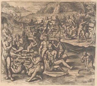
Heinrich Aldegrever, etc. 15 old master prints. 16th-17th centuries. Aldegrever works include "ManTremont Auctions4.6(294)See Sold PriceFeb 25, 2024
Sold1859 Survey Map of New Mexico"Sketch of Public Surveys in New Mexico 1859."". Upper left corner margin ""Sen. Ex: Doc. No 2 - 1st Session 30th Congress". Lithograph by J. Bien, 60 Fulton Street N.Y. Good condition with age toningSee Sold Price
Sold3 New Mexico Maps, 1859, 1860, 18631) Sketch of Public Surveys in New Mexico to accompany the annual survey general for 1863. 20x20â€. John A. Clark. Aging along folds. 2) Sketch of Public Surveys in New Mexico to accompany the annuSee Sold Price
Early Survey Map of New MexicoHeading: (New Mexico) Author: Pelham, William Title: Sketch of Public Surveys in New Mexico, to Accompany Report of Surveyor General 1856 Place Published: Washington Publisher: Date Published: </See Sold Price
SoldSurvey map of Arizona & New Mexico 1855Title: Route near the 32nd Parallel of North Latitude. Map No.2. From the Pimas Villages to Fort Fillmore Author: Parke, John G. Description: Lithographed map. 61x98 cm. (24x38½").Southern New MexicoSee Sold Price
1859 SURVEY MAP OF HEMPSTEAD HARBOR, LONG ISLAND, NEWScarce and detailed engraved map of Hempstead Harbor Long Island published in 1859 by the "Survey of the Coast of the United States" 1:20 000 scale. The plate measures approx. 16.25 x 18 in.See Sold Price
1859 SURVEY MAP OF HEMPSTEAD HARBOR, LONG ISLAND, NEWScarce and detailed engraved map of Hempstead Harbor, Long Island, published in 1859 by the 'Survey of the Coast of the United States', 1:20,000 scale. The plate measures approx. 16.25 x 18 in., withSee Sold Price
SoldColton: Antique Map of New Mexico & Utah, 1859Title/Content of Map: New Mexico & Utah with today's Arizona & Nevada Date Printed: 1859 Cartographer: H. J. Colton Material/Medium: Paper Size: 17 1/2" x 15" Hand colored engraved. Published in New YSee Sold Price
SoldMap of Public Surveys in New MexicoSketch of the public surveys in New Mexico. Surveyor General - 1855.See Sold Price
MAP, New Mexico, MorleyOne of the Earliest Maps Dedicated to New Mexico Territory. New Mexico. William Morley, Morley's Map of New Mexico Compiled from the Latest Government Surveys and Other Reliable Sources, 1873 (dated).See Sold Price
Sold(MAP) Sketch of Public Survey New Mexico, 1862, 21 1/2(MAP) Sketch of Public Survey New Mexico, 1862, to accompany the Annual Report of the Surveyor General for 1862. Private land claims and Pueblo Indian Grants surveyed, townships subdivided, shows miniSee Sold Price
Very Important Map of New Mexico & Utah (with AZ & NV). By Colton, 1859Title: Very Important Map of New Mexico & Utah (with AZ & NV). By Colton, 1859 Date/Period: 1859 Materials: Hand colored steering engraved Size: 17 1/2 x 14 1/2” This map, created by J. H. ColtoSee Sold Price
US Coast Survey Map of New York Bay & Hudson RiverSketch B No. 3, showing the progressive of the survey in New York Bay and Hudson RIver from 1851 to 1859 Published Washington D.C. 1859, includes inset maps of "Hudson River from Albany to New BaltimoSee Sold Price
Sold5 Antique Maps of New Mexico[Five Antique Maps of New Mexico], incl. "Sketch of Public Surveys of New Mexico", 1862; "Archaeological Map of Pajarito Park", 1900; "Sketch of Public Surveys...", 1861; "Territory of New Mexico", 18See Sold Price
WHEELER LAND CLASSIFICATION MAP CENTRAL NEW MEXICOFramed atlas map on paper, land classification map of part of central New Mexico, United States Geographical surveys west of the one hundredth meridian, expeditions of 1876 and 1877 under the commandSee Sold Price
SoldFirst map of New Mexico 1873Heading: Author: Morley Title: Morley's Map of New Mexico Compiled from the latest Government Surveys and other reliable sources Place Published: Cimarron, New Mexico Publisher:Harry Whigham & C.A. BSee Sold Price
SoldFive Maps of New Mexico[Five Antique Maps of New Mexico], incl: "Sketch of Public Surveys of New Mexico", 1862; "Archaeological Map of Pajarito Park", 1900; "Sketch of Public Surveys...", 1861; "Territory of New Mexico", 18See Sold Price
SoldMacomb map of New Mexico, Colorado etc. 1860Title: Map of Explorations and Surveys in New Mexico and Utah made under the direction of the Secretary of War by Capt. J.N. Macomb, Topl. Engrs. assisted by C.H. Cimmock, C. Engr. 1860 Author: MacombSee Sold Price
Sketch of Public Surveys in New Mexico...Title/Content of Map: Sketch of Public Surveys in New Mexico... Cartographer: CLARK, JOHN A. Date: 1862 Publisher: SURVEYOR GENERAL OF NEW MEXICO Size: 21Height - 28Width Map of New Mexico showing itSee Sold Price
Sold(Maps and Charts, North America), Folding map of N(Maps and Charts, North America), Folding map of New Mexico and Arizona, Old Territory and Military Departments of New Mexico, Bureau of Topographical Engineering of the War Department, 1859 correctedSee Sold Price
SoldU S Coast Survey 1896 LG Map. New Orleans Texas Florida"Sketch of General Progress June 30. 1896" Showing Southern, Eastern and Mid West States, incl Florida, Texas, Gulf of Mexico, Georgia etc. Large Lithograph Map Published 1896, Washington for "U.S. CoSee Sold Price
SoldSketch of Public Surveys in New Mexico 1860Title: Sketch of Public Surveys in New Mexico Author: U.S. State Surveys Description: Lithographed map by J. Bien. 58x82.5 cm. (22¾x32½").New Mexico before Arizona was named stretching from CalifornSee Sold Price
SoldMAP "SKETCH OF PUBLIC SURVEYS IN NEW MEXICO", 1860Unframed map, "Sketch of Public Surveys in New Mexico, 1860", A.P. Wilbar, Surveyor General of New Mexico, includes portions of areas identified as California, Utah, Kansas, identifies locations of InSee Sold Price
Sold13 1859 U.S. Coastal Survey MapsDESCRIPTION: Collection of thirteen 1859 United States coastal survey maps from a trigonometrical survey. Includes: St. Mary's River, Maryland; New York Bay and Hudson River; Port Royal Entrance of SoSee Sold Price
JEFFERSON DAVIS NEW MEXICO MAP NO. 2'Explorations and Surveys for a Rail Road Route from the Mississippi River to the Pacific Ocean - War Department - Route Near the 35th Parallel - Map No. 2 - From the Rio Grande to the Pacific Ocean -See Sold Price
Rand McNally & Co's New Ideal State and County Survey and Atlas 1911North American Artifact Auctions4.6(184)See Sold PriceApr 20, 2024
Map of Mexico, Central America, New Grenada, Venzuela and the West IndiesJasper524.5(9.8k)See Sold PriceFeb 27, 2024