2 Illuminated Books of Hours LeavesSchmidt's Antiques Inc. Since 19114.8(440)See Sold PriceMar 02, 2024
Illuminated Manuscript Leaf of The CrucifixionSchmidt's Antiques Inc. Since 19114.8(440)See Sold PriceMar 02, 2024
RARE 1930s AUTOGRAPH BOOK FEATURING RUTH & GEHRIGJohn McInnis Auctioneers,LLC4.5(505)See Sold PriceFeb 25, 2024
Timetable, Paper and Ephemera Lot-Eastern USA RailroadsJM Hobby Supply and Railroad Artifact Auctions4.4(127)See Sold PriceFeb 24, 2024
SCARCE 1971 Kim Il Sung Signed Book "ON THE WORK OF THE WOMAN'S UNION"Rbfinearts4.5(579)See Sold PriceFeb 24, 2024
1885 CIVIL WAR 1ed Famous Memoirs US Grant Sheridan Sherman 6v RARE LOT MapsSchilb Antiquarian Rare Books4.8(431)See Sold PriceMar 10, 2024
"WINTER AND SUMMER IN MAINE" 1904 PHOTO ALBUMJohn McInnis Auctioneers,LLC4.5(505)See Sold PriceFeb 25, 2024
1821 THE (3) VOYAGES of CAPT JAMES COOK VOL. I-VIIJohn McInnis Auctioneers,LLC4.5(505)See Sold PriceFeb 24, 2024
[BASEBALL]. [SHEET MUSIC]. KALBFLEISCH, J. H. The Live Oak ...Potter & Potter Auctions4.6(550)See Sold PriceMar 07, 2024
Illuminated Manuscript Leaf of The VisitationSchmidt's Antiques Inc. Since 19114.8(440)See Sold PriceMar 02, 2024
Illuminated Manuscript Leaf of GethsemaneSchmidt's Antiques Inc. Since 19114.8(440)See Sold PriceMar 02, 2024
c1700s RARE Arabic Handwritten Manuscript Middle East Persia Journal ARABIASchilb Antiquarian Rare Books4.8(431)See Sold PriceMar 10, 2024
SoldChart of the Mediterranean, c.1750Heading: Author: Seale, Richard William Title: Correct Chart of the Mediterranean Sea, from the Straits of Gibraltar to the Levant; from the Latest and Best Observations: For Mr. Tindal's ContinuatioSee Sold Price
SoldLarge Antique Nautical Chart MEDITERRANEAN ADRIATICDetails: This lot consists of a large rolled map, best described by its own title: "A General Chart of THE MEDITERRANEAN, Adriatic and Black Seas; TOGETHER WITH The Grecian Archipelago CONSTRUCTED PRSee Sold Price
SoldMichelot (Henri) and Laurent Bremond. [Eastern MedMichelot (Henri) and Laurent Bremond. [Eastern Mediterranean chart],untitled chart from Carte Generalle dele Mer Mediterranee, with Greece, Turkey, the Holy Land, Northern Egypt, Crete and CypSee Sold Price
SoldAntique Nautical Chart of West Mediterranean SeaMap: Old nautical chart of the west Mediterranean Sea Subtitle: Mediterranean Sea, Gibraltar to Alicante, Cape Spartel to Cape Ferrat from Spanish and French Government Charts to 1877. Creator: BritisSee Sold Price
SoldThomson: Antique Chart Map of Mediterranean Sea, 1817Chart of the Mediterranean Sea. Bay & roads of Marseilles. The harbour of Genoa. Plan of the Rock and Bay of Gibraltar, shewing the position of the combined fleet and attack of the battering ships inSee Sold Price
Thomson: Chart of the Mediterranean Sea, 1817Title/Content of Map: 'Chart of the Mediterranean Sea. Bay & roads of Marseilles. The harbour of Genoa. Plan of the Rock and Bay of Gibraltar, shewing the position of the combined fleet and attack ofSee Sold Price
Chart of the Mediterranean, 1848-50Map: Chart of the Mediterranean Size: Folio – 19.50 H x 24.00 W Inches Publisher: George Philip & Son 1848-1850 Ca. Liverpool Margin stain, small fold tear. Five small inset harbor charts with soundSee Sold Price
Cooper: Antique Chart of the Mediterranean, 1802Title/Content of Map: Antique chart of the Mediterranean Sea related to the Battle of the Nile in 1798 Date Printed: 1802 Cartographer: Willyams, Cooper Size (inches): 18 x 8 Striking, detailed, and uSee Sold Price
SoldCHART OF THE MEDITERRANEANLater copy of a J W Norie chart of The Mediterraneanand the Grecian Archipelago. Showing Italy, Sardinia,Corsica, part of France, etc. Framed, Dimensions: 36 tall by 67 longSee Sold Price
Chart of the MediterraneanTitle: Chart of the Mediterranean Printing Date: c1848-1850 Cartographer: PHILIP, GEORGE & SON Publisher: GEORGE PHILIP & SON Size: 19.5Height - 24Width Additional Information: Five small inset harborSee Sold Price
SoldA correct chart of the Mediterranean Sea…Richard William Seale , A correct chart of the Mediterranean Sea from the Straits of Gibraltar to the Levant. 1745 Incisione in rame in coloritura dei confini e cartigli. mm 350x725. Foglio: mm 392x74See Sold Price
Antique Chart of the Mediterranean, 1848Title/Content of Map: Chart of the Mediterranean Date Printed: c1848-1850 Cartographer: PHILIP, GEORGE & SON Size (inches): 19.5X24 Margin stain, small fold tear.Five small inset harbor charts with soSee Sold Price
Chart of the Mediterranean Sea. Marseilles Genoa Gibraltar. THOMSON 1817 mapTITLE/CONTENT OF MAP: 'Chart of the Mediterranean Sea. Bay & roads of Marseilles. The harbour of Genoa. Plan of the Rock and Bay of Gibraltar, shewing the position of the combined fleet and attack ofSee Sold Price
1817 Chart of the Mediterranean SeaBy: John Thomson Date: 1817 (dated) Dimensions: 19.25 x 23.75 inches (48.9 x 60.3 cm) This elegant large map of the Mediterranean Sea and the countries surrounding it was published in Johnson’s AtlaSee Sold Price
SoldWestern Mediterranean sea chart. Ports lighthouses mail routes. LARGE 1952 mapTITLE/CONTENT OF MAP: 'The Western Mediterranean; Inset Lisbon; Bordeaux; Gibraltar; Barcelona; Marseilles; Algiers; Tunis; Palermo; Genoa; Venice; Naples' DATE PRINTED: 1952 IMAGE SIZE: Approx 49.0 xSee Sold Price
Chart of the Mediterranean Sea. Marseilles Genoa Gibraltar. THOMSON 1817 mapTITLE/CONTENT OF MAP: 'Chart of the Mediterranean Sea. Bay & roads of Marseilles. The harbour of Genoa. Plan of the Rock and Bay of Gibraltar, shewing the position of the combined fleet and attack ofSee Sold Price
Antique chart of the Mediterranean Sea related to theTitle/Content of Map: Antique chart of the Mediterranean Sea related to the Battle of the Nile in 1798 Date Printed: 1802 Cartographer: Willyams, Cooper Size (in): 18 x 8 Striking, detailed, and unusuSee Sold Price
Chart of the Mediterranean Sea. Marseilles Genoa Gibraltar. THOMSON 1817 mapTitle: "Chart of the Mediterranean Sea". Marseilles Genoa Gibraltar. THOMSON 1817 map Description: Chart of the Mediterranean Sea. Bay & roads of Marseilles. The harbour of Genoa. Plan of the Rock andSee Sold Price
Western Mediterranean sea chart. Ports lighthouses mail routes. LARGE 1927 mapTITLE/CONTENT OF MAP: The Western Mediterranean [inset Lisbon; Bordeaux; Gibraltar; Barcelona; Marseilles; Algiers; Tunis; Palermo; Genoa; Venice; Naples; Trieste] DATE PRINTED: 1927 IMAGE SIZE: ApproSee Sold Price
"Chart of the Mediterranean Sea". Marseilles GenoaTITLE/CONTENT OF MAP: 'Chart of the Mediterranean Sea // Bay & roads of Marseilles // The harbour of Genoa // Plan of the Rock and Bay of Gibraltar, shewing the position of the combined fleet and attaSee Sold Price
Western Mediterranean sea chart. Ports lighthouses mail routes. LARGE 1959 mapTITLE/CONTENT OF MAP: 'The Western Mediterranean; Inset Lisbon; Bordeaux and Gironde; Gibraltar; Haifa; Barcelona; Marseilles; Algiers; Tunis; Palermo; Genoa; Venice; Naples' DATE PRINTED: 1959 IMAGESee Sold Price
Western Mediterranean sea chart. Ports lighthouses mail routes. LARGE 1959 mapTITLE/CONTENT OF MAP: 'The Western Mediterranean; Inset Lisbon; Bordeaux and Gironde; Gibraltar; Haifa; Barcelona; Marseilles; Algiers; Tunis; Palermo; Genoa; Venice; Naples' DATE PRINTED: 1959 IMAGESee Sold Price
SoldC. 1725 Admirals Charts of the MediterraneanLeather (original) covered book of Admiralty Charts dating to Circa 1725. The book held additional charts which were removed at some point. Ten Engravings are included, some are pictured. All are twoSee Sold Price
SoldCaribbean Island Map, by Mount & Page, 1720 (rare &Spectacular sea chart of the Spanish Main to Puerto Rico, from Mount & Page's English Pilot, Fourth Book. Known as the most important English Atlas of Sea Chart covering the Mediterranean and North AmSee Sold Price
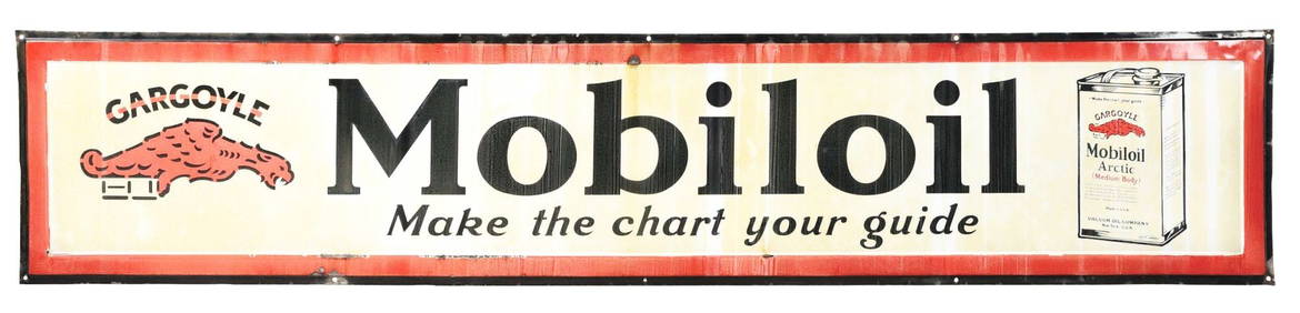
MOBILOIL "MAKE THE CHART YOUR GUIDE" PORCELAIN SIGN W/ OIL CAN & GARGOYLE GRAPHIC.Dan Morphy Auctions4.2(1.3k)See Sold PriceFeb 24, 2024
LATE 18TH C. VERY LARGE CHART OF NORTHEAST CANADA BY DES BARRES (1721-1824), 1780, FRAMEDThomaston Place Auction Galleries4.4(394)See Sold PriceFeb 24, 2024
LARGE LATE 17TH C. DUTCH CHART OF CANADA, GREAT LAKES, NEW FRANCE, LABRADOR, HUDSON BAY, BY PIERREThomaston Place Auction Galleries4.4(394)See Sold PriceFeb 24, 2024
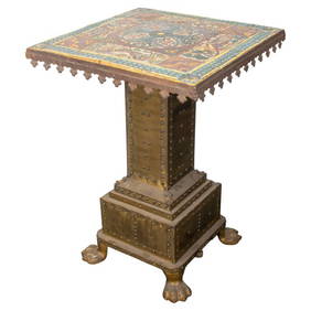
Mediterranean Gothic Revival Faience Top TableAuctions at Showplace4.6(744)See Sold PriceMar 03, 2024
CHART "LONG ISLAND SOUND FROM NEW YORK TO MONTOCK POINT ..." New York, 1830 21" x 77" sight. FramedEldred's4.7(423)See Sold PriceFeb 27, 2024
CHART "SOUTHERN COAST OF LONG ISLAND FROM MONTAUK POINT TO EAST HAMPTON" Circa 1877 11.25" x 22.75"Eldred's4.7(423)See Sold PriceFeb 27, 2024
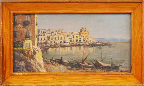
Signed Antique Italian Coastal Mediterranean Sea Original Framed Beach Scene Oil PaintingCurated Gallery Auctions4.6(138)See Sold PriceFeb 25, 2024
Vintage Zuni Mediterranean Coral Cluster Cuff BraceletBilly The Kid Auction House4.8(828)See Sold PriceMar 03, 2024
MEDITERRANEAN SEASCAPE OIL ON CANVAS BY BERNSTEINLewis & Maese Antiques & Auction4.4(533)See Sold PriceFeb 25, 2024


![[BASEBALL]. [SHEET MUSIC]. KALBFLEISCH, J. H. The Live Oak ... (1 of 5)](https://p1.liveauctioneers.com/928/318880/171361400_1_x.jpg?height=282&quality=70&version=1707501302)