SoldDOUBLE-PAGE ENGRAVED AND HAND-COLORED EARLY MAPof North Africa and present day Saudi Arabia, titled "Presbiteri Iohannis, Si Ve Abissino RVM Imperii Descripto", likely that this map is Ortelius Map #175, 15x17in.See Sold Price
SoldDOUBLE-PAGE ENGRAVED AND HAND-COLORED EARLY MAPof Flandria or current day Belgium, likely that this map is Ortelius Map #75, frayed edges and repaired tears, 15x20in.See Sold Price
DOUBLE-PAGE ENGRAVED AND HAND-COLORED EARLY MAPtitled "Anglias Et Hibernia Nova", information verso suggests that the map is from "Ptolemy's Geography issued either in 1598 or 1599, Venice.", 7x9in. The Knoop CollectionSee Sold Price
SoldDOUBLE-PAGE ENGRAVED AND HAND-COLORED EARLY MAPdepicting central and southern Italy, or as the Latin text reads in part, "The Kingdom of Naples", likely that this map is Ortelius Map #139, 14x19in.See Sold Price
Sold2 Maps: Scythia [1729] + De Fer, L'Asie 1717[Asia]. 2 double-page engraved maps, early hand-colored. Overall in very good condition, lightly toned. ++ Nicolas de Fer. L'Asie Suivant Les Nouvelles Decouvertes Dont Les Point Principaux Sont PlaceSee Sold Price
SoldEarly Map of “America Septentrionalis” by LotterHistoric Maps Beautiful Early Map of “America Septentrionalis” by Lotter c. 1760 Hand-Colored Engraved Copper Plate Double-Page Map titled, “America Septentrionalis,” Guillaume de L’Isle, GuSee Sold Price
Soldc. 1760 Beautiful Map of AMERICA SEPTENTRIONALISHistoric Maps Beautiful Early Map of “America Septentrionalis” by Lotter c. 1760 Hand-Colored Engraved Copper Plate Double-Page Map titled, “America Septentrionalis,” Guillaume de L’Isle, GuSee Sold Price
Soldc. 1760 Beautiful Map of AMERICA SEPTENTRIONALISHistoric Maps Beautiful Early Map of “America Septentrionalis” by Lotter c. 1760 Hand-Colored Engraved Copper Plate Double-Page Map titled, “America Septentrionalis,” Guillaume de L’Isle, GuSee Sold Price
SoldSchenk, map of Transylvania, c.1700s[Transylvania]. Pieter Schenk. Nova Et Accurata Transylvaniae Descriptio. c.1690s - early 1700s. Double-page engraved map. 15 3/8 x 19 3/4 in. Early hand-colored outline, both cartouches colored.See Sold Price
SoldMUENSTER, SEBASTIAN. Typus Orbis Universalis.MUENSTER, SEBASTIAN. Typus Orbis Universalis. Double-page wood-engraved world map, 310x405 mm sheet size, ample margins, Latin text on verso; hand-colored at an early date; some scattered browning, paSee Sold Price
SoldMAP: c. 1720 "Regni Mexicani seu Novae Hispaniae"Historic MapsCirca 1720 "Regni Mexicani seu Novae Hispaniae" Homann c. 1720, Hand-colored, Double-page Engraved Map, Titled "REGNI MEXICANI SEU NOVAE HISPANIAE, LUDOVICIANAE, N. ANGLIAE, CSee Sold Price
SoldMAP: c. 1720 Regni Mexicani seu Novae HispaniaeHistoric MapsCirca 1720 "Regni Mexicani seu Novae Hispaniae" Homann c. 1720, Hand-colored, Double-page Engraved Map, Titled "REGNI MEXICANI SEU NOVAE HISPANIAE, LUDOVICIANAE, N. ANGLIAE, CSee Sold Price
SoldANVILLE, JEAN BAPTISTE BOURGUIGNON d'. A ComplANVILLE, JEAN BAPTISTE BOURGUIGNON d'. A Complete Body of Ancient Geography. 13 engraved maps, all but one double-page; all hand-colored in outline. Folio, 545x390 mm, early 1/4 roan, very worn; firstSee Sold Price
1792 Elwe World Map Mappe Monde1792 Elwe World Map Mappe Monde Ou Description Du Globe Terrestre & Aquatique J. Elwe After A. Jaillot 1792 Amsterdam. 18 X 24 In. Double Page Engraved Hand Colored Map by Elwe After Jaillot's 1694 MaSee Sold Price
SoldNicolaum Visscher engraved hand-colored mapNicolaum Visscher- ''Hispania et Portugalliae Regna''- double page engraved hand-colored map, ca. 1680-1720, cartouche with queen, shield and cupids. 19 1/4 x 23''See Sold Price
SoldCary's New Universal Atlas,Containing Distinct Maps of All the Principal States and Kingdoms, etc., London: Printed for J. Cary, Engraver, 1811, with 56 double-page engraved hand-colored maps on 60 numbered sheets (complete), rSee Sold Price
DOUBLE-PAGE ENGRAVED AND HAND-COLORED MAP OF ARRASNorthern France, a map panel references Atrebatum, the Roman name for Arras, depicting town buildings, roads and fortifications, coat of arms in upper center, information verso suggests map is from BrSee Sold Price
SoldPartientrionalee De L'Amerique Map.Double Page Engraved and Hand Colored Map of the Eastern Seaboard of the United States. Includes Ohio to New York and down through The Carolinas. Paris 1755. Nice Margins. 20" x 26".See Sold Price
SoldCarte Geographique et Historique de la Carolinec. 1825, "Carte Geographique, Statistique et Historique de la Caroline du Sud"; double page engraved and hand colored map of South Carolina showing various rivers, trails, and villages; map surroundedSee Sold Price
SoldVintage Map, Daniel Stoopendaal, Wereit CaertDaniel Stoopendaal (Amsterdam, circa 1680), "Werelt Caert," double-page engraved hand-colored double-hemisphere world map depicting California as an island with corner vignettes depicting allegoricalSee Sold Price
SoldJanssonius Joannes Nova Belgica Et Anglia Nova doubleJanssonius Joannes Nova Belgica Et Anglia Nova double page engraved map, hand colored, ss 15 1/2" x 20"See Sold Price
SoldSTOOPENDAAL, DANIEL. Werelt Caert. [Amsterdam, c. 1680](MAP) STOOPENDAAL, DANIEL Werelt Caert. (Amsterdam, c. 1680). Double-page engraved hand-colored double-hemisphere world map depicting California as an island. With corner vignettes depicting allegoricSee Sold Price
Sold(MAP) JANSSON, JAN. Buckingamiae Comitatus cum(MAP) JANSSON, JAN Buckingamiae Comitatus cum Bedfordiensi; vulgo Buckingamshire and Bedfordshire. Amsterdam, ca. 1645. Double-page engraved map hand-colored in outline. With decorative cartouche andSee Sold Price
SoldMAP -- DE BRY, Theodore. Floridae Americae ProvincMAP -- DE BRY, Theodore. Floridae Americae Provinciae.Frankfurt: 1591 or later. Double-page engraved map, hand-colored (sheet size: 370 x 480 mm). Condition: lower margin trimmed with signifSee Sold Price
Rare 19thc German Handcolored Costume Plates, 17thc NobilityConnoisseur Auctions3.9(336)See Sold PriceMar 02, 2024
17th Century Hand Colored Engraved Map of GermanyGlobal Auctions Company4.3(36)See Sold PriceMar 03, 2024
18th Century Hess Germany Hand colored Engraved MapGlobal Auctions Company4.3(36)See Sold PriceMar 03, 2024
Hand Colored Engraved Map of Europe, Jean Baptiste Bourguignon Anville 1754Global Auctions Company4.3(36)See Sold PriceMar 03, 2024
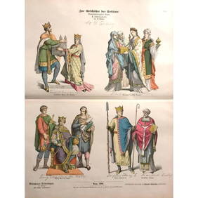
Rare 19thc German Handcolored Costume Plates, ByzantinesConnoisseur Auctions3.9(336)See Sold PriceMar 16, 2024
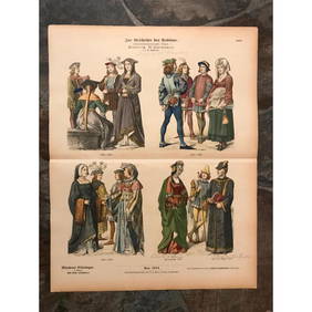
Rare 19thc Costume Plates, 13th Century Knights Templar, Royalty, ScholarsConnoisseur Auctions3.9(336)See Sold PriceMar 16, 2024
Rare 19thc German Costume Plates, 14thc KnightsConnoisseur Auctions3.9(336)See Sold PriceMar 16, 2024
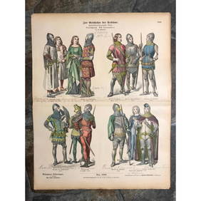
Rare 19thc Handcolored Costume Plates, 15thc KnightsConnoisseur Auctions3.9(336)See Sold PriceMar 16, 2024


![2 Maps: Scythia [1729] + De Fer, L'Asie 1717 (1 of 2)](https://p1.liveauctioneers.com/179/15522/5074001_1_x.jpg?height=282&quality=70&version=1206672512)


![STOOPENDAAL, DANIEL. Werelt Caert. [Amsterdam, c. 1680] (1 of 1)](https://p1.liveauctioneers.com/197/58374/28679608_1_x.jpg?height=282&quality=70&version=1405541743)