SoldChart of the Northwest Coast of America, explored byChart of the Northwest Coast of America, explored by the Boussole and Astrolabe in 1786 3rd sheet published as the Act directs Nov 1t 1798 by G.G. & J Robinson Paternoster Row London, showing part ofSee Sold Price
La Perouse Chart of NW Coast on 3 sheets 1798Title: Chart of the North West Coast of America. Explored by the Boussole and Astrolabe in 1786 Author: La Pérouse, Jean François Galaup de Description: Copper-engraved chart on 3 sheets. Each sheetSee Sold Price
Second edition of Roberts/Cook Chart of Northwest CoastHeading: (Cook, James) Author: Roberts, Henry Title: Chart of the N. W. Coast of America and the N. E. Coast of Asia, Explored in the Years 1778 and 1779. Prepared by Lieut’t Henry Roberts, under thSee Sold Price
SoldRare 1st edition of Roberts/Cook Chart of NorthwestHeading: (Cook, James) Author: Roberts, Henry Title: Chart of the N. W. Coast of America and the N. E. Coast of Asia, Explored in the Years 1778 and 1779. Prepared by Lieut’t Henry Roberts, under thSee Sold Price
SoldVancouver: Antique Chart of Northwest Coast of AmericaTitle/Content of Map: A Chart Shewing Part of the Coast of N.W. America, with the Tracks of His Majesty's Sloop Discovery and Armed Tender Chatham . . . [Columbia River to Northern California] Date PrSee Sold Price
1786 Views of Alaska and Vancouver IslandItem: 1786 Views of Alaska and Vancouver Island Description: Views of the North West Coast of America explored by the Boussole & Astrolabe in 1786 (1st, 2nd and 3rd Sheets) Excellent images capured asSee Sold Price
Map of Views of the North West Coast of America, 1798Map: Views of the North West Coast of America explored by the Boussole & Astrolabe in 1786 (1st, 2nd and 3rd Sheets) Maker: G Robinson (pub.) / J La Perouse Date: 1798 Origin: London Size: 10.7 x 16.8See Sold Price
Views of Alaska and Vancouver Island, 1786Map: 1786 Views of Alaska and Vancouver Island -- Views of the North West Coast of America explored by the Boussole & Astrolabe in 1786 (1st, 2nd and 3rd Sheets) Cartographer: G Robinson (pub.) / J LaSee Sold Price
Views of Alaska and Vancouver Island, 1786Title/Content of Map: 1786 Views of Alaska and Vancouver Island -- Views of the North West Coast of America explored by the Boussole & Astrolabe in 1786 (1st, 2nd and 3rd Sheets) Date Printed: 1798, LSee Sold Price
Sold1786 Views of Alaska and Vancouver IslandTitle/Content of Map: 1786 Views of Alaska and Vancouver Island -- Views of the North West Coast of America explored by the Boussole & Astrolabe in 1786 (1st, 2nd and 3rd Sheets) Date Printed: 1798, LSee Sold Price
Collection of 10 U.S. survey maps from 1798-1896Title: Collection of 10 U.S. survey maps Author: ** Description: With: La Pérouse. Views of the North West Coast of America explored by the Boussole & Astrolabe in 1786. 2nd Sheet. Copper-engraved viSee Sold Price
SoldCollection of 10 U.S. survey maps from 1798-1896Title: Collection of 10 U.S. survey maps Author: ** Description: With: La Pérouse. Views of the North West Coast of America explored by the Boussole & Astrolabe in 1786. 2nd Sheet. Copper-engraved viSee Sold Price
Perouse: Views of Alaska & Vancouver Island, 1786Map: 1786 Views of Alaska and Vancouver Island -- Views of the North West Coast of America explored by the Boussole & Astrolabe in 1786 (1st, 2nd and 3rd Sheets) Cartographer: G Robinson (pub.) / J LaSee Sold Price
Antique Views of Alaska & Vancouver Island, 1786Title/Content of Map: 1786 Views of Alaska and Vancouver Island -- Views of the North West Coast of America explored by the Boussole & Astrolabe in 1786 (1st, 2nd and 3rd Sheets) Date Printed: 1798, LSee Sold Price
LA PEROUSE. Lot of 9 maps, sold togetherLA PEROUSE. Lot of 9 maps sold together. Engraved maps hand coloured in outline. Each approx. 38 x 49 cm.VUES DE LA COTE DU NORD-OUEST DE L'AMERIQUE. ** CHART OF THE NORTHWEST COAST OF AMERICA. ** PLASee Sold Price
SoldDixon Chart of Northwest Coast 1789Title: To the Right Honorable the Lords Commissioners ... this Chart of the North West Coast of America, with the Tracks of the King George and Queen Charlotte in 1786 & 1787... Author: Dixon, GeorgeSee Sold Price
SoldTwo copper-engraved maps with later hand-coloringAuthor: La Pérouse, Jean Francois Galaup de Description: Includes: A Chart of the North-West Coast of America. 18.7x11.2 cm. * Plan of Port des Français on the North West Coast of America, in LatituSee Sold Price
SoldRussian Chart of West Coast with S.F. Bay 1848-[71]Heading: Author: Russia, Maritime Ministry Title: [in Russian] Mercator Chart of the Eastern Ocean with the Northwest Coast of America between the Port of Monterey and Queen Charlotte Sound compiledSee Sold Price
SoldRare Spanish charts of Northwest CoastHeading: Author: Galiano, Dionisio and Cayetano Valdés Title: Carta Esferica de los reconocimientos hechos en 1792 en la Costa N.O. De America de los reconocimientos hechos...[&] Carta Esferica de lSee Sold Price
SoldBonne (Rigobert) North West Coast of AmericaBonne (Rigobert) North West Coast of Americathe North Pacific and Behring Straits, engraved chart, 405 x 670mm., old folds, one with a faint damp-stain, [Paris], c.1780; with 4 other related cSee Sold Price
Oceania.- A Chart exhibiting the New Discoveries iOceania.- A Chart exhibiting the New Discoveries in the North & South Pacific Ocean,also those on the North-west Coast of America, from the Arctic Sea to south of New Zealand, with Van Dieman'See Sold Price
SoldCaptain James Cook, Chart of the NW Coast of America…COOK, James (1728-1779). Chart of the NW Coast of America and NE Coast of Asia explored in the Years 1778 & 1779. London: G. Nichol and T. Cadell, 1785. Originally published in Captain Cook’s VoyageSee Sold Price
Sold* ROBERTS, Henry. Chart of the N.W. coast of America* ROBERTS, Henry. Chart of the N.W. coast of America and N.E. coast of Asia explored in the years 1778 & 1779. London: William Faden, 1 January 1794. Engraved map of the Pacific coasts of Asia and AmeSee Sold Price
Map of New Discoveries in Pacific Ocean 1802Map: A Chart Exhibiting the New Discoveries in the North & South Pacific Ocean, Also Those of The North-West Coast of America, and On The Eastern Coast Of Tartary Maker: George Alexander Cooke Size: QSee Sold Price
NORTHWEST COAST, 19TH - EARLY 20TH C. TOTEM POLEThomaston Place Auction Galleries4.4(393)See Sold PriceFeb 25, 2024
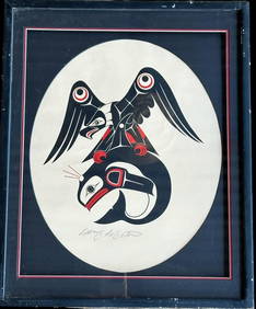
Doug LaFortune (1953) Signed Original Haida Tribal Art Print Northwest CoastCowboy Joe's Antiques4.7(201)See Sold PriceFeb 27, 2024
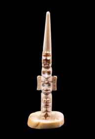
Inuit Alaska Carved Animal Shaped Bowl Signed Spencer Tirlalip Northwest CoastCowboy Joe's Antiques4.7(201)See Sold PriceFeb 27, 2024
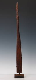
Food Spatula, Geelvink Bay, Northwest Coast Papua New Guinea, Early 20th C. or OlderMaterial Culture4.6(778)See Sold PriceFeb 29, 2024
2 11/16" Zoomorphic Lizard Effigy Pendant Colombia River Valley Northwest Coast, Made from ColorfulHeartland Artifact Auctions4.6(792)See Sold PriceMar 10, 2024
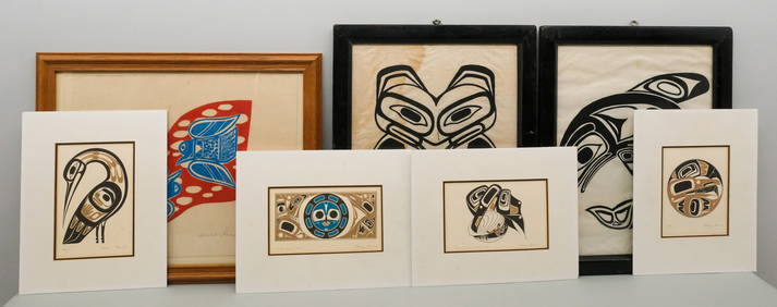
Lot of Pacific Northwest Coast PrintsOld Kinderhook Auction Company4.6(217)See Sold PriceMar 05, 2024
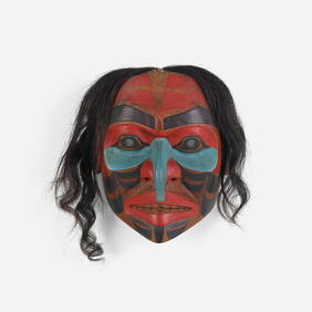
Don Lelooska, Untitled (Northwest Coast mask)Toomey & Co. Auctioneers4.7(392)See Sold PriceFeb 29, 2024
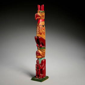
First Nations Northwest Coast Wood Totem Poles (2)Artemis Fine Arts4.8(1.4k)See Sold PriceFeb 26, 2024
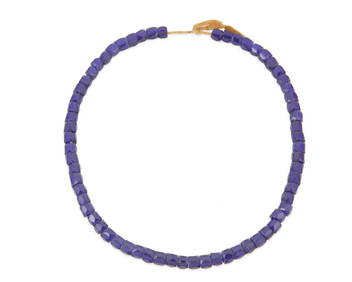
A strand of Russian/Eastern European blue glass trade beadsJohn Moran Auctioneers, Inc.4.7(461)See Sold PriceMar 12, 2024


![Russian Chart of West Coast with S.F. Bay 1848-[71] (1 of 1)](https://p1.liveauctioneers.com/642/85141/43843462_1_x.jpg?height=282&quality=70&version=1456252159)