Sold1777 Map: The City and Environs of PhiladelphiaHistoric Maps 1777 “A Plan Of The City and Environs of Philadelphia" American Revolutionary War Map, Matthew Albert Lotter 1777-Dated Revolutionary War Period, Hand-colored Engraved Map titled, “ASee Sold Price
Sold1777 Map: The City and Environs of PhiladelphiaHistoric Maps 1777 "A Plan Of The City and Environs of Philadelphia" American Revolutionary War Map, Matthew Albert Lotter 1777-Dated Revolutionary War Period, Hand-colored Engraved Map titled, "A PlaSee Sold Price
Sold1777 Map: The City and Environs of PhiladelphiaHistoric Maps 1777 “A Plan Of The City and Environs of Philadelphia" American Revolutionary War Map, Matthew Albert Lotter 1777-Dated Revolutionary War Period, Hand-colored Engraved Map titled, “ASee Sold Price
1777 Map: The City and Environs of PhiladelphiaHistoric Maps 1777 "A Plan Of The City and Environs of Philadelphia" American Revolutionary War Map, Matthew Albert Lotter 1777-Dated Revolutionary War Period, Hand-colored Engraved Map titled, "A PlaSee Sold Price
1777 Map of the CITY AND ENVIRONS OF PHILADELPHIAAmerican Revolution 1777 Colored Map titled: "A PLAN OF THE CITY AND ENVIRONS OF PHILADELPHIA" by Matthew A. Lotter 1777-Dated Revolutionary War Period, Hand-Colored Map titled, "A PLAN OF THE CITY ANSee Sold Price
1777 Map of the CITY AND ENVIRONS OF PHILADELPHIAAmerican Revolution 1777 Colored Map titled: "A PLAN OF THE CITY AND ENVIRONS OF PHILADELPHIA" by Matthew A. Lotter 1777-Dated Revolutionary War Period, Hand-Colored Map titled, "A PLAN OF THE CITY ANSee Sold Price
Sold1777 Map of the CITY AND ENVIRONS OF PHILADELPHIAAmerican Revolution 1777 Colored Map titled: "A PLAN OF THE CITY AND ENVIRONS OF PHILADELPHIA" by Matthew A. Lotter 1777-Dated Revolutionary War Period, Hand-Colored Map titled, "A PLAN OF THE CITY ANSee Sold Price
Sold1777 Map of the CITY AND ENVIRONS OF PHILADELPHIAHistoric Maps 1777 Colored Map titled: "A PLAN OF THE CITY AND ENVIRONS OF PHILADELPHIA" by Matthew A. Lotter 1777-Dated Revolutionary War Period, Hand-Colored Map titled, "A PLAN OF THE CITY AND ENVISee Sold Price
Sold1777, MAP OF CITY OF PHILADELPHIA, MATHIAS LOTTERMatthew Albert Lotter (German, 1741-1810). "A Plan of The City and Environs of Philadelphia" -1777. Hand colored engraving. Elaborately framed. Approx. 34.25" x 29" (frame), approx. 24" x 18.5" (sightSee Sold Price
SoldLate 18th Century Map of PhiladelphiaMap titled "A Plan of the City and Environs of Philadelphia Engraved and Published by Matthew Albert Lotter. 1777". This framed map measures 23.5" x 18" (sight) and is housed in a frame measuring 29"See Sold Price
SoldLotter, map of Philadelphia, 1778[Philadelphia]. Matthew Albert Lotter. A Plan Of The City And Environs Of Philadelphia. 1777. Double-page engraved map from Lotter's ''Atlas Geographique De Cent Et Huit Carte Generales Et Speciales..See Sold Price
SoldLOTTER, Matthias Albrecht (1741-1810). Plan of the CityLOTTER, Matthias Albrecht (1741-1810). Plan of the City and Environs of Philadelphia. Augsburg: Lotter, 1777.  Hand-colored engraved map, overall sheet 26 ¼ x 21 in. (665 x 534 mm), matted aSee Sold Price
SoldSCULL, Nicholas; and George HEAP - William FADEN.SCULL, Nicholas; and George HEAP - William FADEN. A Plan of the City and Environs of Philadelphia.London: William Faden, 12 March 1777. Double-page engraved map (635 x 470 mm). Table of distSee Sold Price
SoldSCULL, Nicholas; and George HEAP - Matthew AlbertSCULL, Nicholas; and George HEAP - Matthew Albert LOTTER. A Plan of the City and Environs of Philadelphia.Nuremberg: Matthew Albert Lotter, 1777. Double-page engraved map, hand-colored (600 xSee Sold Price
Sold1 piece. Engraved Map. Faden, William, after Scul1 piece. Engraved Map. Faden, William, after Scull, N.; Heap, G. A Plan of the City and Environs of Philadelphia." (London), 1777. First state. 24 5/8 x 18 1/16; 625 x 458 mm, trimmed just within platSee Sold Price
SoldEngraved Map. Lotter, Matthew, after Sc1 piece. Engraved Map. Lotter, Matthew, after Scull, Nicholas; Heap, George. "A Plan of the City and Environs of Philadelphia." (Augsburg), 1777. 23 1/4 x 18 inches; 590 x 457 mm. Trimmed at plate marSee Sold Price
SoldLotter Plan of PhiladelphiaLOTTER, Matthew Albert (1741-1810). After Nicolas Scull and George Heap. Plan of the City and Environs of Philadelphia. Hand-colored engraving. Augsburg: Matthew Albert Lotter, 1777. 25 1/4 x 20 1/8 iSee Sold Price
SoldFrederick Bourquin, Map of the City of Boston and itsBOURQUIN, Frederick (b. 1808). Map of the City of Boston and its Environs. Philadelphia: G. M. Hopkins, & Co., 1874. Lithographed, original hand color in full. 35 x 29 inches (unframed).See Sold Price
SoldPlan of the City and Environs of Philadelphia, 1777Nicholas Scull and George Heap (American, 18th Century) A Plan of the City and Environs of Philadelphia Engraved and Published by Matthew Albert Lotter, 1777, hand-colored engraving, 23-3/4 x 18-1/4 iSee Sold Price
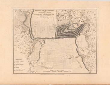
Sold[U.S./PHILADELPHIA]. Matthew Lotter. A Plan O[U.S./PHILADELPHIA]. Matthew Lotter. A Plan Of The City And Environs Of Philadelphia. [Augsbourg], 1777. 23 1/2 x 18. Wash and outline color, with view of State House, based on Faden. Horizontal foldSee Sold Price
SoldLarge map of Tacoma Washington, 1890Heading: (Washington - Tacoma) Author: Plummer, Frederick G. Title: Whitney's Map of the City of Tacoma and Environs, Washington Place Published: Philadelphia Publisher:Everts & Howell, engraversSee Sold Price
SoldMap of PhiladelphiaA Plan of the City and Environs of Philadelphia - Reproduced by Rand McNaly from an original 25 1/2 x 19.See Sold Price
Map of PhiladelphiaA Plan of the City and Environs of Philadelphia - Reproduced by Rand McNaly from an original 25 1/2 x 19.See Sold Price
Map of PhiladelphiaA Plan of the City and Environs of Philadelphia - Reproduced by Rand McNaly from an original 25 1/2 x 19.See Sold Price
Collection of 10 Maps of Cities in Israel for TouristsLevy Auction House4.3(11)See Sold PriceFeb 27, 2024
Hand Colored Map of the city of Amsterdam 1720Global Auctions Company4.3(36)See Sold PriceMar 03, 2024
Mitchell - Map of the City of Washington (Washington, DC)Trillium Antique Prints & Rare Books4.5(32)See Sold PriceFeb 24, 2024
1829 GERMAN-LANGUAGE ANTIQUE AMERICAN BIBLE ILLUSTRATED WITH MAPS OF PHILADELPHIANY Elizabeth 4.2(86)See Sold PriceMar 03, 2024
Vintage Street Map of Pittsburgh, Pennsylvania - Rand McNallyProverde Auctions4.3(3)See Sold PriceFeb 28, 2024
Coca Cola 1993 New Orleans Basketball TubeRapid Estate Liquidators and Auction Gallery4.5(1.1k)See Sold PriceFeb 27, 2024
Laminated Unique Media New York City MapRapid Estate Liquidators and Auction Gallery4.5(1.1k)See Sold PriceFeb 29, 2024
8PC United States Police Department Guide BooksBruneau & Co. Auctioneers4.5(491)See Sold PriceMar 18, 2024


![[U.S./PHILADELPHIA]. Matthew Lotter. A Plan O (1 of 1)](https://p1.liveauctioneers.com/179/10971/2682789_1_x.jpg?height=282&quality=70&version=1162265652)