Two printed maps after N.C. Wyeth, 15 1/2'' x 18''Two printed maps after N.C. Wyeth, 15 1/2'' x 18''.See Sold Price
SoldN. C. Wyeth, Map of Discovery, Eastern & WesternTwo framed vintage prints / maps after N.C. Wyeth. "Map of Discovery, Eastern & Western Hemisphere". Signed and dated in the prints 1927. The images measure 15.5" x 17.75". Framed and matted under glaSee Sold Price
SoldTwo Rare Maps published in National Geographic by WyethNational Geographic Eastern and Western Hemispheres Maps. NC Wyeth (1822-1945). Chromolithograph. Washington, DC, 1928. Each: 16 3/4 x 18 1/2 inches sheet. In 1927, famed American painter N. C. WyethSee Sold Price
SoldPAIR NC WYETH NAT GEO 1928 MAPSTwo Rare National Geographic Eastern and Western Hemispheres Chromolithographic Maps by NC Wyeth (1822-1945). Washington, DC, 1928. Each: 16 3/4 x 18 1/2 inches sheet. Fold lines visible, as is frequeSee Sold Price
SoldBloody Old NC Wyeth Print Alaskan Mail Man & WolfN.C. Wyeth print titled "Alaskan Mail Carrier", 8 dead wolves around the mail man with the crazy look on his face, two sulking wolves in the background. 12" x 15" as framed, good condition.See Sold Price
SoldTwo Antique MapsMap of Northern Hemisphere: Carte Des Nouvelles Decouvertes Au Nord De La Mer Du Sud, 18" x 24 1/2" (sight) Francois Santini, Venice and Map Of North America: Nuove Scoperte De' Russi, 12" x 15 3/4" (See Sold Price
Sold3 Maps incl PA and NCAlso includes "A correct map of North America". MEASUREMENTS: 14" high X 17 1/2" wide. Status Republica Genuensis. MEASUREMENTS: 15-1/2” high X 18-1/2” wide. Pennsylvania map printed by Singerly aSee Sold Price
SoldTWO 19TH CENTURY MAPS OF ENGLAND AND WALESIncludes an 1841 map of England by H.S. Tanner, matted, 15.75 x 12.5 inch sight size. Also an 1863 map of England and Wales by Johnson and Ward, unmatted, 26.5 x 18 inches overall.See Sold Price
SoldTWO 19TH CENTURY MAPS OF THE PACIFIC NORTHWESTIncludes a map of Washington and Oregon, circa 1868, professionally matted, 15.75 x 12 inch sight size; plus an unmatted map of the region by Johnson and Ward, circa 1860's. 14 x 18 inches overall.See Sold Price
SoldAbraham Ortelius (1527-1598): EuropaeAbraham Ortelius (1527-1598): EuropaeTogether with European School: Europa nach gelegenheit, two engraved maps with hand-coloring.13 1/2 x 18 in. (sight), 18 3/4 x 24 3/4 in. (frame), 12 3/4 x 15 1/4See Sold Price
SoldTwo Miscellaneous Manuscript Mapsprobably 18th century, possibly drawn by James Sever, ink on laid paper, one depicting the Hampshire Grants, 15-1/2 x 12-5/8 in.; one depicting the Massachusetts coast, watermark "D*CB LAUW", 18-1/4 xSee Sold Price
SoldTwo Maps of the American North WestLot of two unframed maps of the American North West, one published by Alvin Johnson & Son, New York (18" h x 14" w), the other published by S. Augustus Mitchell (12 1/4" h x 15 1/4" w). Provenance: FrSee Sold Price
SoldTwo horse prints and small Austrian bronze dog1st item: Colored etching after Carl Vernet, DOGS HAVING LAST SCENT, printed by Debucourt, sight: 12' H x 18-3/4' W, Frame: 15" H x 21-3/4" W. Older brown stained wooden frame. 2nd item: Patinated broSee Sold Price
Sold1794 English Pilot: Description of the Caribbee IslandsTitle/Content of Map: 1794 English Pilot: Description of the Caribbee Islands Date Printed: 1794, London Cartographer: Mount and Davidson Size: 12 1/4" x 18 3/4" Two pages of coastal profiles of (on tSee Sold Price
Johnson: Antique Map of Maryland and Delaware, 1863Title/Content of Map: 1863 Johnson Map of Maryland and Delaware Date Printed: 1863, New York Cartographer: A Johnson Size: 12.5 x 15.8 in. A very nice map of these two mid-Atlantic states with plentySee Sold Price
SoldJ. H. COLTON & CO. 2 MAPS, WISCONSIN & SUPERIORJ. H. COLTON & CO. (19TH C.), MAPS, TWO, 15" X 18", WISCONSIN & LAKE SUPERIOR:Likely from Colton's Atlas of the World, including "Lake Superior and the Northern Part of Michigan", No. 43, 14 1/2" x 18See Sold Price
SoldPrinted map of the Old Dominion HoundsPrinted map of the Old Dominion Hounds. 15" x 18"See Sold Price
SoldROBERT ADAMS, b. 1937Dead Palms, Partially Uprooted, Ontario, California, 1983 Gelatin silver print, printed 1989. 15 x 18 ½ in. (38.1 x 47 cm). Signed, titled, dated and numbered 5/30 in pencil on the verso. ExhibSee Sold Price
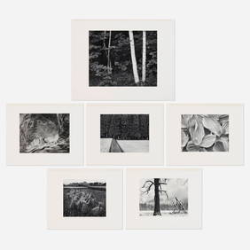
SoldCollection of five pencil illustrations in the maCollection of five pencil illustrations in the manner of N.C. Wyeth, sheet size - 15 7/8'' x 12 1/4''.See Sold Price
SoldHoratio Henry Couldrey (1832-1918) United Kingdom (two)KITTENS & DOGS, 1871, a pair of oil paintings on canvas, each signed and dated lower right, each 9 ½ x 12 ½”, frames 15 ½ x 18 ½”. (2) Provenance: SOGA Auction Slovakia lots 208 & 209.See Sold Price
SoldJulian Ritter (1909-2000) Hawaii (two)CLOWNS, a pair, each an oil painting on Masonite, signed lower right, 9 x 12” & 12 x 9”, frames 15 ½ x 18” & 18 x 15 ½”. (2)See Sold Price
SoldTwo Maps of New EnglandReproductions. Colonial Prototyopes of House Beautiful Houses together with New England Map of Chief Auto Routes. 12" x 18-1/2"; 22" x 17"See Sold Price
SoldEight (8) Augustus Mitchell MapsCollection of eight maps including New Jersey/Maryland Delaware 1872, Two north and South Carolina 1872 maps (15" x 12"), Minnesota 1890 , Florida and the Carolinas 1860, County map of the state of ArSee Sold Price
SoldJansson, [Veteris Pannonia] Map[Veteris Pannonia Utriusque Nec Non Illyrici], Joannis Jansson geographer, circa 1647, hand-colored map printed in Amsterdam, unframed, 15-1/8 x 18-3/4 in. (plate), 22-1/2 x 26 in. (page)See Sold Price
1830 MINIATURE WATERCOLOR PORTRAIT OF A YOUNG BOYThomaston Place Auction Galleries4.4(389)See Sold PriceFeb 24, 2024
RARE 1638 HONDIUS MAP OF BERMUDA, FRAMEDThomaston Place Auction Galleries4.4(389)See Sold PriceFeb 24, 2024
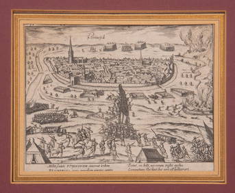
16TH C. BIRDSEYE VIEW OF SEIGE OF STEENWYCK, NETHERLANDS BY FRANS HOGENBERG (1535-1590)Thomaston Place Auction Galleries4.4(389)See Sold PriceFeb 24, 2024
Medieval Printed Paper Bible Page by Johann GrüningerTimeLine Auctions Ltd.4.6(182)See Sold PriceMar 07, 2024
The Wizard’s Book of Magic, or, Evening Amusements, for the...Potter & Potter Auctions4.6(544)See Sold PriceFeb 24, 2024
Vintage Full Color World Map LithographThe Benefit Shop Foundation Inc.4.3(2.9k)See Sold PriceFeb 28, 2024
Vintage Framed Pine Island & Lacoste Island MapThe Benefit Shop Foundation Inc.4.3(2.9k)See Sold PriceMar 06, 2024
[RECONSTRUCTION - SUFFRAGE]. The Two Records. Voters. Read and Remember. A Black Record / A BlackerFreeman's | Hindman4.4(1.6k)See Sold PriceFeb 27, 2024
Two G-Men FBI Fingerprint Game Sets in Original Boxes, The New York Toy & Game Co. 1937Hoch LTD.4.5(74)See Sold PriceFeb 25, 2024
3 Chaim Gross Orig. Lithos Musicians, Blessing the CandlesConcept Art Gallery4.7(509)See Sold PriceMar 06, 2024
Set of 2 Child's Caned Thonet Style ChairsOld Kinderhook Auction Company4.6(217)See Sold PriceMar 05, 2024
Friedrich Kallmorgen (1856-1924) Oil on Canvas PaintingAkiba Galleries4.7(1.8k)See Sold PriceFeb 29, 2024
AFRICA. Shooting a Leopard eating Antelope (Field Sports- Edward Orme) 1814Jasper524.5(9.8k)See Sold PriceFeb 28, 2024
9.18 ctw Emerald and 0.66 ctw Diamond 18K Yellow and White Gold PendantSeized Assets Auctioneers4.3(601)See Sold PriceFeb 26, 2024
Carl Johan Billmark - Set of 4 Prints depicting Rome, Italy - Church in Sweden - Views of EuropeProverde Auctions4.3(3)See Sold PriceFeb 28, 2024


![Jansson, [Veteris Pannonia] Map (1 of 1)](https://p1.liveauctioneers.com/33/60071/29671613_1_x.jpg?height=282&quality=70&version=1408739570)


![[RECONSTRUCTION - SUFFRAGE]. The Two Records. Voters. Read and Remember. A Black Record / A Blacker (1 of 3)](https://p1.liveauctioneers.com/197/319238/171468093_1_x.jpg?height=282&quality=70&version=1707520367)