ATLAS of ANTIENT GEOGRAPHY by SAMUEL BUTLER 1843John McInnis Auctioneers,LLC4.6(504)See Sold PriceFeb 24, 2024
18TH C. ANTIQUE MAP: FRENCH & INDIAN WAR, FRAMEDThomaston Place Auction Galleries4.4(389)See Sold PriceFeb 24, 2024
Rand McNally Railroad Map Cabinet w/ 21 Railroad MapsRail & Road Auctions4.6(165)See Sold PriceMar 08, 2024
Keith Haring - Ink on New York Map, Best Buddies, Inscribed, Signed, and DatedSapphire Auction Gallery4.1(67)See Sold PriceMar 02, 2024
LATE 17TH C. FRENCH MAP OF THE NEW WORLD BY ALEXIS-HUBERT JAILLOT (1632-1712)Thomaston Place Auction Galleries4.4(389)See Sold PriceFeb 24, 2024
Central Railroad of New Jersey Map of Sandy Hook Route-ca. 1903JM Hobby Supply and Railroad Artifact Auctions4.4(126)See Sold PriceFeb 24, 2024
Lot of Six Mixed Atlas Box Cars-HO Scale-New in BoxJM Hobby Supply and Railroad Artifact Auctions4.4(126)See Sold PriceFeb 25, 2024
Rand McNally/Santa Fe Railroad Map of Iowa-1912JM Hobby Supply and Railroad Artifact Auctions4.4(126)See Sold PriceFeb 24, 2024
NICOLAES VISSCHER (NETHERLANDS, 1618-1709) MAP OF THE NEW WORLDThomaston Place Auction Galleries4.4(389)See Sold PriceFeb 24, 2024
17TH C. WORLD MAP BY NICOLAES VISSCHER (NETHERLANDS, 1618-1709)Thomaston Place Auction Galleries4.4(389)See Sold PriceFeb 24, 2024
Lot of Six Mixed Atlas Cabooses-HO Scale-New in BoxJM Hobby Supply and Railroad Artifact Auctions4.4(126)See Sold PriceFeb 25, 2024
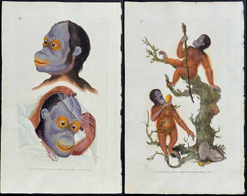
SoldLOT OF TWO ANTIQUE MAPSLOT OF TWO ANTIQUE MAPS. 1. PLAN OF ATHENS FOR THE TRAVELS OF ANACHARISIS. (1784) 2. TOPOGRAPHY OF OLYMPIA. (1780) Height: 10 1/2 in. by Width: 16 in.See Sold Price
SoldTwo Antique MapsTwo Antique Maps. Map of United States and Texas, dated 1839 by Daniel Burgess and a Map of Mexico Central America and the West Indies, dated 1867 by S Augustus Mitchell.See Sold Price
SoldTwo Antique Framed MapsA pairing of two antique framed maps: a colored map of France dated 1627, and a map of Asia dated 1744. Both in gilt frames under glass. Map of Asia: 19-3/4 x 20 in.See Sold Price
Sold2 Antique Maps, c. 1600, Florence & YorkshireTwo Antique Handcolored Maps, c. 1600, Florence by Don Stephano, late 16th c. & Yorkshire by John Speed, early 17th c. {ACGQ7041/2} (TC ) Dimensions: Florence 13.5 x 18.5, framed 20x25; the YorkshireSee Sold Price
SoldAntique Maps (two)BRITANNIA; AMERICAE, two engravings with hand-coloring and center-fold as issued, the first published by Milliaria Gallica, frame 19 ¾ x 25” with glass, the second sight 19 ½ x 23”, frame 28 x 3See Sold Price
SoldANTIQUE GERMAN MAPS, TWO PIECESANTIQUE GERMAN MAPS, TWO PIECES, H 13", W 17":Including one framed engraving depicting North America; noted in German in the upper left "After the drawing by William Delisle, published by Joh Justin GSee Sold Price
SoldTwo Maps of Philadelphia Antique Cloth Handkerchiefs.Two 19th Century Maps of Philadelphia Cloth Handkerchiefs. Depicts a printed central map of Philadelphia surrounded by busts of Washington, franklin, Jefferson and Penn. With alternating views of theSee Sold Price
SoldPair of Antique German Etchings of Maps of Battle SceneThis lot contains two framed Antique German Etchings of Battle Scenes Maps between foot soldiers, archers, and mounted Calvary. Both pieces show, in great detail, the horror of battle both on land andSee Sold Price
SoldTerreni: Antique Map of Cuba, 1763Map: Carta Esatta rappresentante l'Isola di Cuba Cartographer: Terreni Place & Date: Livorno / 1763 Size: 12 1/2" x 10 1/4" Condition: b&w; two small wormholes in Bahamian waters A beautifully ornateSee Sold Price
Homann Heirs: Antique Map of the World, 1746Map: World Date Printed: 1746 Cartographer: Homann Heirs Material/Medium: Paper Size: 23 3/4" x 21" Printed in Nuremberg. Thick paper. Features the world in double hemispheres. Two projections show poSee Sold Price
Homann Heirs: Antique Map of World in Hemispheres, 1746Map: Planiglobi Terrestris Mappe Monde Date Printed: 1746 Cartographer: Homann Heirs Material/Medium: Paper Size: 23" x 21 1/3" Condition: Excellent The World in double Hemispheres. Two proejctions shSee Sold Price
Tallis: Antique Maps of Western & Eastern HemisphereTitle/Content of Map: Western & Eastern Hemisphere by Tallis, circa 1853 (set of 2 maps) Date Printed: 1853 Cartographer: John Tallis Material/Medium: Lithograph Dimensions: 10 3/4" x 14 1/4" Set of tSee Sold Price
SoldFullarton: Antique Map of United States, 1859[United States]. Edinburgh: A. Fullarton & Co, [1859]. Engraved by G. H. Swanston, with hand coloured outlines. Approximately 18-3/8 x 22-3/8 inches, two sheets joined. Margins a little age toned, elsSee Sold Price
SoldMitchell: Antique Map of Arizona and New Mexico, 1870Title/Content of Map: 1870 Mitchell Map of Arizona and New Mexico -- Arizona and New Mexico Date Printed: 1870, Philadelphia Cartographer: S Mitchell Size: 11.5 X 13.8 in. Handsome map of these two deSee Sold Price
Antique Map and Prints of the Great Boston Fire, 1872Title/Content of Map: 1872 Map and Prints of the Great Boston Fire -- Boston Fire Date Printed: 11 30 1872 New York Cartographer: Harper's Weekly Size: 13.5 x 20.5 in. (map) A large, detailed two pageSee Sold Price
SoldANTIQUE MAP OF THE WORLDTwo page, hand colored engraving. Dimensions: Frame H 26.5" x W 28.5", Sight H 18" x W 20.75" Condition: No issues to noteSee Sold Price
Sold2 VINTAGE / ANTIQUE MAPSTwo Framed Maps. 1- Town of Patterson, Putnam County NY. In Frame 17"x14"x3/4". 2- Vintage Reproduction of A New and Accvat Map of the World. 16 3/4"x21 3/4"x3/4". Weight combined 7 pds.See Sold Price
SoldFramed Antique Map, Mexico & FloridaFramed antique map of Mexico and Florida. Plate marks visible. hand-colored. Map is set behind glass in wood frame in two-tone wood style frame. Measures approximately 23 inches in height by 28 inchesSee Sold Price
SoldFramed Antique Map, EuropaFramed antique map of Europe. Plate marks visible. hand-colored. Hand-written information along verso Of frame. Map is set behind glass in wood frame in two-tone wood style frame. Measures approximateSee Sold Price
SoldFramed Antique Map, ItaliaFramed antique map of Italia. Plate marks visible. hand-colored. Hand-written information along verso Of frame. Map is set behind glass in wood frame in two-tone wood style frame. Measures approximateSee Sold Price
SoldMap of Georgia & 2 Floridas from the best AuthoritiesCirca 1796 Antique Map. Title: "A Map of Georgia also the two Floridas from the best Authorities". Citation: Amos Doolittle, Sculp. Approximate size: 12-5/8" x 8-3/8". Please note that this lot has aSee Sold Price
Sold2 Antique 19thC. Leather Family Bibles 1825Lot of two antique Bibles. With ornate gold embossed details on spine, gorgeous marbled endpapers. Marked Family Bibles of previous owners. Includes maps, charts, and etchings. Publisher: BrattleboroSee Sold Price
17TH C. ANTIQUE MAP SIEGE OF LA ROCHELLE, FRANCE, FRAMEDThomaston Place Auction Galleries4.4(389)See Sold PriceFeb 24, 2024
18TH C. ANTIQUE MAP: FRENCH & INDIAN WAR, FRAMEDThomaston Place Auction Galleries4.4(389)See Sold PriceFeb 24, 2024
Two (2) Antique 18th C. Copper Engraved Framed Maps - America & EuropeMagnusson Art Group4.5(50)See Sold PriceMar 14, 2024
William Simpson's Sketches at the Seat of War - Two Volumes with 81 Hand-colored LithographsTrillium Antique Prints & Rare Books4.5(30)See Sold PriceFeb 24, 2024
First Copy of Gautier's Le Roman de la Momie - 13 Original Watercolors by George Barbier (2 VolumesTrillium Antique Prints & Rare Books4.5(30)See Sold PriceFeb 24, 2024
Mckenney & Hall - Two Octavo Volumes of Text with Rare Plate of Billy BowlegsTrillium Antique Prints & Rare Books4.5(30)See Sold PriceFeb 24, 2024
Original Watercolor of AmaryllisTrillium Antique Prints & Rare Books4.5(30)See Sold PriceFeb 24, 2024
Original Watercolor of AmaryllisTrillium Antique Prints & Rare Books4.5(30)See Sold PriceFeb 24, 2024
Original Watercolor of Fritillary & ButterflyTrillium Antique Prints & Rare Books4.5(30)See Sold PriceFeb 24, 2024
Donovan - Pair: Rufous Orang Outang (Orangutan): Wild Man of the Woods & Two Studes of the HeadTrillium Antique Prints & Rare Books4.5(30)See Sold PriceFeb 24, 2024
NORTH AFRICA. Morocco Algeria Tunis Tunisia Egypt. Cairo. BARTHOLOMEW 1901 mapJasper524.5(9.8k)See Sold PriceFeb 28, 2024
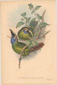
AFRICA. 'Reptiles & Birds'. Snakes Cerastes Hair/hood/horn serpents. CHILD 1746Jasper524.5(9.8k)See Sold PriceFeb 28, 2024
Blackie (Pub) 1882 Folio Map. World on Mercators ProjectionAlbion Auctions4.6(341)See Sold PriceMar 01, 2024
TWO ANTIQUE JEWISH NATIONAL FUND CHARITY BOXES. The first one made in Berlin c. 1920J. Greenstein & Co., Inc.4.3(55)See Sold PriceApr 16, 2024