BECHLER, Gustavus R. Atlas Showing Battles....13. [ATLAS]. BECHLER, Gustavus R. Atlas Showing Battles, Engagements, and Important Localities Connected with the Campaigns in Virginia, CompleSee Sold Price
SoldBechler. Atlas...Campaigns in Virginia, c.1864[Civil War Atlas]. Gustavus R. Bechler. Atlas Showing Battles, Engagements, And Important Localities Connected With The Campaigns In Virginia. Phila: G. R. Bechler, c.1864. Oblong 8vo. Modern leatherSee Sold Price
SoldUntitled. [Siege of Yorktown]Title: Untitled. [Siege of Yorktown] Publication Date: c1870 Cartographer: ANONYMOUS Publisher: R.H. PEASE, lith. Dimension: 8.5 X 5 American copy of an English battle plan showing artillery batteriesSee Sold Price
SoldHistorical Map Of The United States, R. Blanchard, 1876HISTORICAL MAP OF THE UNITED STATES SHOWING EARLY SPANISH, FRENCH & ENGLISH DISCOVERIES AND EXPLORATIONS, ALSO FORTS, TOWNS & BATTLE FIELDS OF HISTORIC INTEREST, lithographed, edited, and published bySee Sold Price
Sold(CIVIL WAR.) Bechler, Gustavus R. Military Map Refering(CIVIL WAR.) Bechler, Gustavus R. Military Map Refering to the Campaigns of the Army of the Potomac in Virginia, Including Adjoining Parts of Maryland & Pennsylvania. Large hand-colored lithographed cSee Sold Price
Map Showing Battle of Oudenaard during the War ofWar of Spanish Succession Map Showing Battle of Oudenaard during the War of Spanish Succession, from Tindal's Continuation of Rapin's History of EnglandSee Sold Price
SoldGerman Historic War Maps, Towns, and Sieges17th and 18th Century German Cartography School, Various Maps showing Battles, Settlements, Wars at German, Swedish, and Dutch Cities, copperplate engravings, approximately 12 x 14.5 inches, approximaSee Sold Price
Julien (R J) Atlas Topographique et MilitaireJulien (Roch Joseph) publisher Atlas Topographique et Militaire, engraved throughout, comprising title, 2 general plans, 55 double-page map sheets, and one battle plan, one or 2 isolated spotsSee Sold Price
SoldItaly.- Franco-Dutch War.- Le Clerc (S.) MessineItaly.- Franco-Dutch War.- Le Clerc (S.) Messine Secourue, Franco-Spanish Sea battle in the period of the Franco-Dutch war of 1672-1678, showing a battle off the coast of Messina, Sicily, engraved vieSee Sold Price
SoldItaly.- Franco-Dutch War.- Le Clerc (S.) La Bataille deItaly.- Franco-Dutch War.- Le Clerc (S.) La Bataille de Palerme, Franco-Spanish Sea battle in the period of the Franco-Dutch war of 1672-1678, showing a battle off the coast of Palermo, Sicily, engravSee Sold Price
SoldATLAS OF THE AMERICAN REVOLUTION AND 2 PAMPHLETS108 page reference book of the American revolution written by Craig L. Symonds, Cartography by William J. Clipson.Filled with maps showing how the battle took place. 1777 Battle of BRANDYWINE DrivingSee Sold Price
SoldATLAS OF THE AMERICAN REVOLUTION AND 2 PAMPHLETS108 page reference book of the American revolution written by Craig L. Symonds, Cartography by William J. Clipson.Filled with maps showing how the battle took place. 1777 Battle of BRANDYWINE DrivingSee Sold Price
ATLAS OF THE AMERICAN REVOLUTION AND 2 PAMPHLETS108 page reference book of the American revolution written by Craig L. Symonds, Cartography by William J. Clipson.Filled with maps showing how the battle took place. 1777 Battle of BRANDYWINE DrivingSee Sold Price
MAP - Dendermonde, Belgium. TindalDendermonde, Belgium. Nicholas Tindal, Plan of the City of Dendermonde, and the Manner in Which It Was Blocked by the Troops of the Allies, 1745 (circa). Hand Color. Fine battle plan showing the defenSee Sold Price
MAP - Dendermonde, Belgium. TindalDendermonde, Belgium. Nicholas Tindal, Plan of the City of Dendermonde, and the manner in which it was blocked by the troops of the Allies, 1745 (circa). Hand Color. Fine battle plan showing the defenSee Sold Price
BATTLE OF BRITAIN SIGNATURES GROUPA group of 20 signatures of R.A.F. pilots and air crew who participated in the historic Battle of Britain, each executed on a handsome memorial postcard honoring the the Battle and showing the memoriaSee Sold Price
Tallis: Map of Black Sea showing Crimean War, 1860Title/Content of Map: 'Black Sea'. Vignettes: Sebastopol (Sevastopol), Varna, Odessa, Sinope (Sinop), Constantinople (Istanbul) & Silistria (Silistra). Showing Crimean War naval battles.Scandinavia RuSee Sold Price
Tallis: Antique Map of BLACK SEA.Showing Crimean WarTITLE/CONTENT OF MAP: 'Black Sea' Showing Crimean War naval battles.Scandinavia Russia. Vignettes: Sebastopol (Sevastopol), Varna, Odessa, Sinope (Sinop), Constantinople (Istanbul) & Silistria (SilistSee Sold Price
1920s Rand McNally Central Europe War MapPaper panels mounted on linen backing from Rand McNally, likely to be around 1920 showing all of the battle fronts from WWI, large fold out format, dimensions are close to 10" wide by 11" tall, makingSee Sold Price
General Drafting Co. Civil War Pictorial Map of BattlesTitle/Content of Map: 1961 General Drafting Co./Esso Civil War Pictorial Map of Battles -- A Pictorial Map Showing Historical Shrines and Battlefields of the Civil War 1861-1865 Date Printed: 1961, CoSee Sold Price
1961 General Drafting Co./Esso Civil War Pictorial MapTitle/Content of Map: 1961 General Drafting Co./Esso Civil War Pictorial Map of Battles -- A Pictorial Map Showing Historical Shrines and Battlefields of the Civil War 1861-1865 Date: 1961, Convert StSee Sold Price
1961 General Drafting Co./Esso Civil War Pictorial MapTitle/Content of Map: 1961 General Drafting Co./Esso Civil War Pictorial Map of Battles -- A Pictorial Map Showing Historical Shrines and Battlefields of the Civil War 1861-1865 Date Printed: 1961, CoSee Sold Price
Sold1961 General Drafting Co./Esso Civil War Pictorial MapTitle: 1961 General Drafting Co./Esso Civil War Pictorial Map of Battles -- A Pictorial Map Showing Historical Shrines and Battlefields of the Civil War 1861-1865 Date: 1961, Convert Station, NJ CartoSee Sold Price
1961 General Drafting Co./Esso Civil War Pictorial MapTitle/Content of Map: 1961 General Drafting Co./Esso Civil War Pictorial Map of Battles -- A Pictorial Map Showing Historical Shrines and Battlefields of the Civil War 1861-1865 Date: 1961, Convert StSee Sold Price
PUROL GASOLINE CAST GLASS GLOBE LENS W/ ARROW GRAPHIC.Dan Morphy Auctions4.2(1.3k)See Sold PriceFeb 25, 2024
1966 DEC. R.F.K. FAMILY CHRISTMAS CARD etcJohn McInnis Auctioneers,LLC4.5(505)See Sold PriceFeb 25, 2024
Roman 'Julius Caesar' Slingshot from the Battle of MundaTimeLine Auctions Ltd.4.6(183)See Sold PriceMar 07, 2024
Pair of Moon New York Central Railroad Locks with KeyRail & Road Auctions4.6(165)See Sold PriceMar 07, 2024
Lake Erie, Wabash & St. Louis Railroad Brass Baggage Tag and Wabash Check TagRail & Road Auctions4.6(165)See Sold PriceMar 07, 2024
Chicago, Milwaukee, St. Paul & Pacific Railroad China Traveler Oval Platter Plates, Bowl, and SaucerRail & Road Auctions4.6(165)See Sold PriceMar 07, 2024
Seven Pieces of Union Pacific Railroad China and Silver - Challenger Plates, Saucers, and DemitasseRail & Road Auctions4.6(165)See Sold PriceMar 07, 2024
John R. Beckwith "Poppy Fest" Oil on CanvasEpic Auctions and Estate Sales4.6(210)See Sold PriceMar 02, 2024
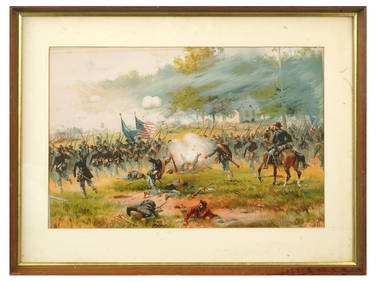
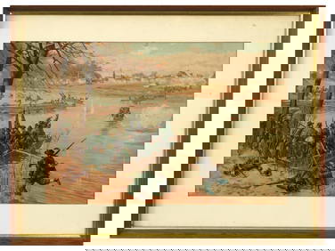
ANTIQUE AMERICAN CIVIL WAR LITHO BY THURE DE THULSTRUPAntique Arena Inc.4.5(878)See Sold PriceFeb 24, 2024
ANTIQUE AMERICAN CIVIL WAR LITHO BY THURE DE THULSTRUPAntique Arena Inc.4.5(878)See Sold PriceFeb 24, 2024
ANTIQUE AMERICAN CIVIL WAR LITHO BY THURE DE THULSTRUPAntique Arena Inc.4.5(878)See Sold PriceFeb 24, 2024
Carey, pub. 1796 - A Chart of the West IndiesTrillium Antique Prints & Rare Books4.5(32)See Sold PriceFeb 24, 2024
Carey, pub. 1796 - Map of the State of MarylandTrillium Antique Prints & Rare Books4.5(32)See Sold PriceFeb 24, 2024
Carey, pub. 1796 - Map of GeorgiaTrillium Antique Prints & Rare Books4.5(32)See Sold PriceFeb 24, 2024
Carey, pub. 1796 - Map of The State of South CarolinaTrillium Antique Prints & Rare Books4.5(32)See Sold PriceFeb 24, 2024
Carey, pub. 1796 - Map of KentuckyTrillium Antique Prints & Rare Books4.5(32)See Sold PriceFeb 24, 2024
Carey, pub. 1796 - Map of the Tennassee State formerly part of North Carolina (Tennessee)Trillium Antique Prints & Rare Books4.5(32)See Sold PriceFeb 24, 2024
R.C. GORMAN (1932-2005) ORIGINAL EXHIBITION LITHOGRAPH, 28IN x 34IN (71cm x 86cm)The Rug Life4.3(13)See Sold PriceMar 07, 2024
Antq 1843 Battle Of Trafalgar Maritime LithographThe Benefit Shop Foundation Inc.4.3(2.9k)See Sold PriceMar 20, 2024


![Untitled. [Siege of Yorktown] (1 of 1)](https://p1.liveauctioneers.com/5584/152686/77105525_1_x.jpg?height=282&quality=70&version=1571789576)