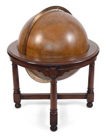
Monumental 19C. Lacquered Wood Terrestrial GlobeHill Auction Gallery 4.7(1k)See Sold PriceFeb 28, 2024
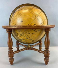
MONUMENTAL FLOOR-STANDING W. & A.K. JOHNSTON 30-INCH TERRESTRIAL GLOBE Edinburgh and London,Eldred's4.7(409)See Sold PriceFeb 28, 2024
Antique Josiah Loring Terrestrial 1850s GlobeMatthew Bullock Auctioneers4.7(1.8k)See Sold PriceMar 02, 2024
Kansas City Southern Lines Cram's Universal Terrestrial Globe 10 1/2"Rail & Road Auctions4.6(165)See Sold PriceMar 08, 2024
A LARGE ANTIQUE W & A K JOHNSTONS 12 INCH TERRESTRIAL GLOBE upon a cast iron base. 54 cm x 24 cm.Hannam's Auctioneers Ltd4.3(386)See Sold PriceFeb 27, 2024
1958 Proof Silver Washington QuarterRichard L. Edwards Auctioneering4.8(2.3k)See Sold PriceFeb 26, 2024
Miniature Antique Rowntrees & Co Ltd York Advertising Terrestrial Globe AtlasJasper524.5(9.8k)See Sold PriceFeb 27, 2024
Antique Geographic 10 Inch Terrestrial Globe Atlas Railways Steamer Sea RoutesJasper524.5(9.8k)See Sold PriceFeb 27, 2024
A Mother of Pearl Gemstone Globe. Gilded metal stand. 43cm x 50cm. In good condition.Cadmore Auctions4.3(41)See Sold PriceFeb 27, 2024
Vintage Topographical Map of Central EuropeVintage Topographical Map of Central Europe from the 1970'sSee Sold Price
Vintage Topographical Map of Central EuropeVintage Topographical Map of Central Europe from the 1970'sSee Sold Price
SoldSix (6) Vintage Prints of MapsLot of Six (6) Vintage Prints of Maps. Images of central Europe, atlas of the world, British colonies in North America, France, and Europe. Size range from 20-3/4 x 26-3/4" W to 15-3/4" H x 13-5/8" W.See Sold Price
Authentic Vintage 1928 - Central Europe MapAuthentic Vintage 1928 - Central Europe Map **|**|** This is a beautiful, 87 year old map of Central Europe. The details are crisp and the aged color has a perfect antique feel. The map is large - meaSee Sold Price
Europe by Arrowsmith & Lewis 1812 old antique vintage map plan chartTITLE/CONTENT OF MAP: 'Transport Map of Central Europe' DATE PRINTED: 1952 IMAGE SIZE: Approx 49.5 x 72.0cm, 19.5 x 28.25 inches (Large); Please note that this is a folding map. TYPE: Antique colour mSee Sold Price
SoldEUROPE. INDUSTRIES. Coal & Iron deposits. BritishTITLE/CONTENT OF MAP: 'Central & Western Europe (Industrial)' DATE: 1920 IMAGE SIZE: Approx 34.0 x 45.0cm, 13.25 x 17.5 inches (Large) TYPE: Vintage colour map CONDITION: Good; suitable for framing. HSee Sold Price
Baltic Sea sea chart. Ports lighthouses mail routes dockyards. LARGE 1959 mapTITLE/CONTENT OF MAP: 'An Atlas of the Great War; Central Europe 1914-1920' DATE PRINTED: 1920 IMAGE SIZE: Approx 21.5 x 26.5cm, 8.5 x 10.5 inches (Medium) TYPE: Vintage colour map; Scale 1:1,225,000.See Sold Price
EUROPE RAILWAYS. double & single track. Narrow gauge.TITLE/CONTENT OF MAP: 'Central & Western Europe (Railways)' DATE: 1920 IMAGE SIZE: Approx 34.0 x 45.0cm, 13.25 x 17.5 inches (Large) TYPE: Vintage colour map CONDITION: Good; suitable for framing. HowSee Sold Price
EASTERN EUROPE. Showing Railways & steamship routes.TITLE/CONTENT OF MAP: 'Central & Western Europe (Railways)' DATE: 1920 IMAGE SIZE: Approx 33.0 x 22.5cm, 13 x 8.75 inches (Large) TYPE: Vintage colour map CONDITION: Good; suitable for framing. HoweveSee Sold Price
SoldEUROPE. INDUSTRIES. Coal & Iron deposits. British consuls. Railways 1920 mapTITLE/CONTENT OF MAP: 'Central & Western Europe (Industrial)' DATE PRINTED: 1920 IMAGE SIZE: Approx 34.0 x 45.0cm, 13.25 x 17.5 inches (Large) TYPE: Vintage colour map CONDITION: Good; suitable for frSee Sold Price
EUROPE RAILWAYS. double & single track. Narrow gauge. Steamship routes 1920 mapTITLE/CONTENT OF MAP: 'Central & Western Europe (Railways)' DATE PRINTED: 1920 IMAGE SIZE: Approx 34.0 x 45.0cm, 13.25 x 17.5 inches (Large) TYPE: Vintage colour map CONDITION: Good; suitable for framSee Sold Price
CZECHOSLOVAKIA, AUSTRIA & HUNGARY. Central Europe post WW2 borders 1947 mapTITLE/CONTENT OF MAP: 'Czechoslovakia, Austria and Hungary' DATE PRINTED: 1947 IMAGE SIZE: Approx 23.0 x 35.0cm, 9 x 13.75 inches (Large) TYPE: Vintage colour atlas map CONDITION: Good; suitable for fSee Sold Price
SoldPropaganda Poster Map Occupation Areas Germany USSR USAOriginal vintage propaganda poster of the Allied occupation areas after World War 2. This colourful and detailed map depicts areas of Germany and central Europe occupied by the Allied nations followinSee Sold Price
Vintage BIG BLOCK WORLD ATLAS PUZZLE & MAPS TriviaVintage BIG BLOCK WORLD ATLAS PUZZLE & MAPS Trivia Educational Block Game. Comes with North and Central America, Europe, Africa, Asia, and Oceania maps. Game is in LN condition. Not sure if there areSee Sold Price
Vintage BIG BLOCK WORLD ATLAS PUZZLE & MAPS TriviaVintage BIG BLOCK WORLD ATLAS PUZZLE & MAPS Trivia Educational Block Game. Comes with North and Central America, Europe, Africa, Asia, and Oceania maps. Game is in LN condition. Not sure if there areSee Sold Price
Vintage BIG BLOCK WORLD ATLAS PUZZLE & MAPS TriviaVintage BIG BLOCK WORLD ATLAS PUZZLE & MAPS Trivia Educational Block Game. Comes with North and Central America, Europe, Africa, Asia, and Oceania maps. Game is in LN condition. Not sure if there areSee Sold Price
Vintage BIG BLOCK WORLD ATLAS PUZZLE & MAPS TriviaVintage BIG BLOCK WORLD ATLAS PUZZLE & MAPS Trivia Educational Block Game. Comes with North and Central America, Europe, Africa, Asia, and Oceania maps. Game is in LN condition. Not sure if there areSee Sold Price
Vintage BIG BLOCK WORLD ATLAS PUZZLE & MAPS TriviaVintage BIG BLOCK WORLD ATLAS PUZZLE & MAPS Trivia Educational Block Game. Comes with North and Central America, Europe, Africa, Asia, and Oceania maps. Game is in LN condition. Not sure if there areSee Sold Price
BIG BLOCK WORLD ATLAS PUZZLE & MAPS Trivia EducationalVintage BIG BLOCK WORLD ATLAS PUZZLE & MAPS Trivia Educational Block Game. Comes with North and Central America, Europe, Africa, Asia, and Oceania maps. Game is in LN condition. Not sure if there areSee Sold Price
SoldNJ TOPOGRAPHICAL MAP CENTRAL HIGHLANDS MORRIS & SUSSEXNJ TOPOGRAPHICAL MAP CENTRAL HIGHLANDS MORRIS & SUSSEX COUNTIES 1888 JOHN C. SMOCK STATE GEOLOGIST, OVERALL DIMENSIONS INCLUDING FRAME 31 3/4 IN X 42 3/4 INSee Sold Price
SoldVintage Topographical Map of Rocky Mountain NationalVintage Topographical Map of Rocky Mountain National Park From 1961See Sold Price
SoldGERMANY general Map. Central Europe. Hungary.TITLE/CONTENT OF MAP: 'GERMANY, General map' The top image on the right hand side shows the entire map. To view a close up of the map showing the level of printed detail, please click on the bottom imSee Sold Price
SoldSix Framed Vintage Topographical Maps Routes of MontSix Framed Vintage Mont Blanc Prints, Maps, Climbing Routes, Etc. Comprising an aerial panorama, another overhead map, two climbing routes, and two landscapes. {Approximate dimensions: Very close in sSee Sold Price
SoldMAP, Central Europe, MercatorCentral Europe, Germany. Mercator/Hondius, Germania, 1619 (published). Hand Color. This beautifully engraved map covers Germany and the heart of Europe, extending from France and Holland to Poland, anSee Sold Price
Soren Bjulf (Danish,Dutch,1890-1958) oil paintingBroward Auction Gallery4.8(277)See Sold PriceMar 17, 2024
MAP - PIETER SCHENK / VALK / JANSSEN Hand Colored superb Map Central Italy c1702Luis Porretta Fine Arts4.3(10)See Sold PriceMar 02, 2024
A "Red Book" of the Greatest War of History 1914North American Artifact Auctions4.6(182)See Sold PriceApr 20, 2024
The First World War A Photographic History 1933. 1st EditionNorth American Artifact Auctions4.6(182)See Sold PriceApr 20, 2024
ARTS AND CRAFTS HAMMERED LAMP BY FREDRICK FIFIELDAntique Arena Inc.4.5(852)See Sold PriceFeb 24, 2024
West Africa by Arrowsmith & Lewis 1812 old antique vintage map plan chartJasper524.5(9.8k)See Sold PriceFeb 28, 2024
Central & East Africa. Zanzibar Tanganyika Rhodesia Congo. TIMES 1956 old mapJasper524.5(9.8k)See Sold PriceFeb 28, 2024
AFRICA. Africa. Britannica 9th edition 1898 old antique vintage map plan chartJasper524.5(9.8k)See Sold PriceFeb 28, 2024
CENTRAL AFRICA. Kongo. British & German East Africa. Kenya Tanzania 1907 mapJasper524.5(9.8k)See Sold PriceFeb 28, 2024
Africa by Arrowsmith & Lewis 1812 old antique vintage map plan chartJasper524.5(9.8k)See Sold PriceFeb 28, 2024
Clarke & Neele 1815 Map. Europe - Recent Political ChangesAlbion Auctions4.6(336)See Sold PriceMar 01, 2024
Theodor Fischer (1862 - 1938) - Set of 4 Bird Prints - Haliaetos Albicilla - Strix LapponicaProverde Auctions4.3(3)See Sold PriceFeb 28, 2024
Theodor Fischer (1862 - 1938) - Set of 4 Bird Prints - Pernis Apivorus - Falco ArcticusProverde Auctions4.3(3)See Sold PriceFeb 28, 2024
Vintage Map of Roman Forum - Vatican City - Versailles parkProverde Auctions4.3(3)See Sold PriceFeb 28, 2024
Vintage Cut to Clear Ajka Crystal Footed Blue Rose Bowl/ Caviar BowlJasper524.5(9.8k)See Sold PriceMar 07, 2024