RARE 1930s AUTOGRAPH BOOK FEATURING RUTH & GEHRIGJohn McInnis Auctioneers,LLC4.5(505)See Sold PriceFeb 25, 2024
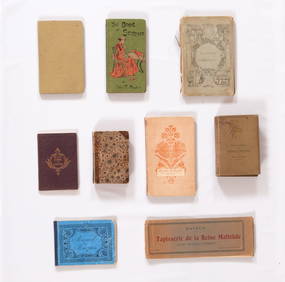
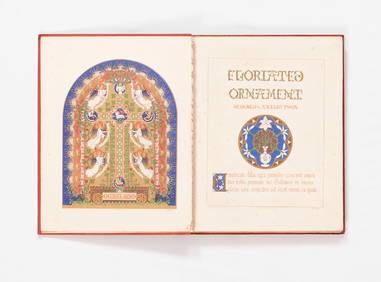
Group of Ten Books: Art of the Embroiderer, Charles Germain de Saint Aubin; Hand Weaving PatternsNazmiyal Auctions4.4(34)See Sold PriceFeb 26, 2024
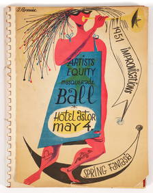
Improvisations II 55 original lithographs Artists Equity Assoc 1951Concept Art Gallery4.7(510)See Sold PriceMar 06, 2024
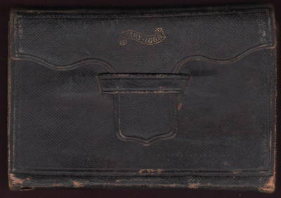
1868 Handwritten diary of Ohio canal boat operator & farmerJasper524.5(9.9k)See Sold PriceFeb 27, 2024
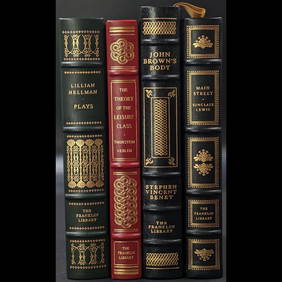
Lot Of 4 Mint Limited Edition Books From The Franklin Library.Rbfinearts4.5(578)See Sold PriceFeb 24, 2024
A Group of Eight Books: Line and Form, Walter Crane (1900); Samplers and Stitches; Designs forNazmiyal Auctions4.4(34)See Sold PriceFeb 26, 2024
First Copy of Gautier's Le Roman de la Momie - 13 Original Watercolors by George Barbier (2 VolumesTrillium Antique Prints & Rare Books4.5(32)See Sold PriceFeb 24, 2024
Group of Nine Books: Handbook of Embroidery; The Book of Stitches, Ellen T. Masters; The Lady'sNazmiyal Auctions4.4(34)See Sold PriceFeb 26, 2024
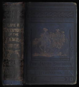
Outlaws of the Border, rare 1882 Jesse James, Younger brothersJasper524.5(9.9k)See Sold PriceFeb 27, 2024
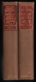
Scarce 1st ed. “Life Histories of African Game Animals?? – T. Roosevelt, E. HellerJasper524.5(9.9k)See Sold PriceFeb 27, 2024
Large lot of exhibition catalogs on CoBrA artistsConcept Art Gallery4.7(510)See Sold PriceMar 06, 2024
Sold1782 New Map of the World Navigation Routes“A New Map of the World in Three Sections wherein the several tracks and discoveries of the British Navigators to the present time are distinctly and accurately laid down”, by J. Bayly, printed atSee Sold Price
Sold1782 A New Map of the World1782 "A New Map of the World", double hemisphere map published by Harrison and Co., London, 1782. Folding map, measures 17 x 10". Fine, mild discoloration. Reserve: $80.00 Shipping: Domestic: Flat-ratSee Sold Price
1782 A New Map of the World1782 “A New Map of the World”, double hemisphere map published by Harrison and Co., London, 1782. Folding map, measures 17 x 10”. Fine, mild discoloration. Reserve: $80.00 Shipping: Domestic: FlSee Sold Price
Sold1782 A New Map of the World1782 “A New Map of the World”, double hemisphere map published by Harrison and Co., London, 1782. Folding map, measures 17 x 10”. Fine, mild discoloration. Reserve: $80.00 Shipping: Domestic: FlSee Sold Price
SoldMap, Bayley, New Map of the World, 1782Map, John Abraham Bayly, A New Map of the World, Including All the Modern Discoveries, 1782, double hemisphere, published by Harrison, London, copper plate engraving, sight: 9.5''h x 15.5''w, frame: 1See Sold Price
AMERICAS. British colonies trade routes; European Colonization 1907 old mapTITLE/CONTENT OF MAP: 'The New World showing British Possessions and trade routes; European Colonization about 1800; The Colonial Empires at the present time' DATE PRINTED: 1907 IMAGE SIZE: Approx 53.See Sold Price
18th-Century Maps of the WorldBeautiful 18th-Century Maps of the World in One Volume ! 1782 Book: “A NEW SYSTEM OF MODERN GEOGRAPHY...,” by William Guthrie, Esq., London, England, Choice Extremely Fine+. 11.5” xSee Sold Price
SoldWorld Map, Dated 1782World map, dated 1782, hand colored engraving, for Miller's New Universal System of Geography, 12 1/2" h x 18 1/2" w (view), 20" h x 26" w (frame). Provenance: CA estate.See Sold Price
MAP, Persia & the Caucasus, KitchinPersia & the Caucasus. Thomas Kitchin, New Map of Persia Divided into Its Provinces from the Latest Authorities, 1782 (circa). Hand Color. This attractive map covers the Persian Empire, which includedSee Sold Price
MAP - New England US. Brion de la TourColonial New England United States. Louis Brion de la Tour, Carte de la Nouvelle Angleterre, Comprenant les Etats de Massachusets Bay, N. Hamp Shire, Connecticut et Rhode Island..., 1782 (published).See Sold Price
1974 World map based on Mercator Projection by Mitchell“Map of the World on the Mercator Projection exhibiting the American Continent as its Center” from the New General Atlas of S. Augustus Mitchell. Shows explorers routes (many of them by CaSee Sold Price
WORLD. Mercator's projection. Ocean currents & shipping routes. BLACKIE 1882 mapTITLE/CONTENT OF MAP: 'The World on Mercators projection showing the courses of the chief ocean currents and the navigation tracks between the principal ports' DATE PRINTED: 1882 IMAGE SIZE: Approx 36See Sold Price
SoldRailroad Photos, Postcards, Maps & MoreRailroad Photos, Postcards, Maps & More: 1.) World's Fair items: 1934 Chicago & Northwestern booklet; The Great Rock Island Route "World's Fair" Line 1891 (could be a reprint); Pennsylvania RR New YorSee Sold Price
Sold"The World's Industrial and Cotton Centennial"The World's Industrial and Cotton Centennial Exposition, Map of New Orleans..." engraving, published New Orleans, 1884-1885, with hand-colored outlines delineating the railway and horse car routes anSee Sold Price
Eastern Hemisphere. New Holland. World on Mercator'sTITLE/CONTENT OF MAP: [Chart of the World on Mercator's Projection - Eastern Hemisphere]The routes taken by numerous explorers are shown, along with dates and various anecdotal notes about their voyagSee Sold Price
MAP - Monmouth, New Jersey. D'AuberteuilMonmouth, New Jersey. Michel Rene Hilliard d'Auberteuil, Plan de la Bataille de Montmouth ou le Gl. Washington Commandait l'Armee Americaine et le Gl. Clinton l'Armee Anglaise, le 28 Juin 1778, 1782 (See Sold Price
Sold11 Vintage MapsDelta airlines system route map, Sinclair salutes the New York’s world fair 1964/65, Jacksonville Florida master street map by Walter Benjamin, 2 street map of Jacksonville, Southeastern BicentSee Sold Price
Sold(4) ATLANTIC OIL ROAD MAPS "WHITE FLASH"(1) Ohio, (1) Delaware, Maryland Virginia and West Virginia, (1) North Carolina, South Carolina, Georgia and Florida; (1) Metropolitan New York and Routes to the New York World's Fair; each having theSee Sold Price
Sold1834 Map of the route passed over by an expedition intoThis highly detailed map depicts the territory of the region between the Red River and Lake Superior within present day Minnesota. The map is centered on the course of the Missisippi River above LakeSee Sold Price
1930 Grande Carte de LA 1930 Map of Central Europe, designed and printed for bicycling and automotive routes. Large folding map.See Sold Price
1930 Grande Carte de L'Europe CentraleA 1930 Map of Central Europe, designed and printed for bicycling and automotive routes. Large folding map.See Sold Price
1796 A General Chart on Mercator’s Projection, toThis fascinating large map, a double folio in black and white is an Exploration Chart of the Eastern Hemisphere which clearly traces the routes of the voyages of the Houghton diplomatic embassy missioSee Sold Price
Sold1782 New Map of the East Indies“A New Map of the East Indies by J. Bayly”, folding map published by Harrison and Co., 1782. Fine, measures 17 x 10”. Reserve: $40.00 Shipping: Domestic: Flat-rate of $5.00 to anywhere within thSee Sold Price
1782 New Map of the East Indies“A New Map of the East Indies by J. Bayly”, folding map published by Harrison and Co., 1782. Fine, measures 17 x 10”. Reserve: $50.00 Shipping: Domestic: Flat-rate of $5.00 to anywhere within thSee Sold Price
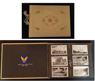
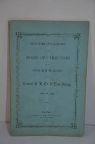
Central Railroad of New Jersey 13th Annual Report-January 1, 1860JM Hobby Supply and Railroad Artifact Auctions4.4(127)See Sold PriceFeb 24, 2024
Central Railroad of New Jersey Map of Sandy Hook Route-ca. 1903JM Hobby Supply and Railroad Artifact Auctions4.4(127)See Sold PriceFeb 24, 2024
New York Central RR The Adirondacks Brochure 1916-1917JM Hobby Supply and Railroad Artifact Auctions4.4(127)See Sold PriceFeb 24, 2024
New York Central and Hudson River RR Public Timetable-November 3, 1901JM Hobby Supply and Railroad Artifact Auctions4.4(127)See Sold PriceFeb 24, 2024
LATE 17TH C. FRENCH MAP OF THE NEW WORLD BY ALEXIS-HUBERT JAILLOT (1632-1712)Thomaston Place Auction Galleries4.4(393)See Sold PriceFeb 24, 2024
NICOLAES VISSCHER (NETHERLANDS, 1618-1709) MAP OF THE NEW WORLDThomaston Place Auction Galleries4.4(393)See Sold PriceFeb 24, 2024
1730 BIBLE in DUTCH ILLUSTRATED w/ MAPS antique MASSIVE FOLIO BIBLIAJasper524.5(9.9k)See Sold PriceFeb 27, 2024
Vintage Holy Bible Old & New Testaments Illustrated 1904The Benefit Shop Foundation Inc.4.3(2.9k)See Sold PriceMar 13, 2024