Gilt Filigree Jeweled Chatelaine Perfume Bottle Belt ClipPassion For Antiques4(24)See Sold PriceFeb 24, 2024
Antique Victorian Fleus de Lis German Silver Chatelaine PurseSuccetti Gallery4.6(84)See Sold PriceFeb 25, 2024
David Yurman Chatelaine Stud Earrings in Sterling Silver with Pave DiamondsArk Auctions Inc3.9(27)See Sold PriceFeb 24, 2024
A velvet ladies purse with silver mount hallmarked London 1903, maker Samuel Jacob with a chatelaineClaydon Auctioneers Ltd4.3(125)See Sold PriceFeb 25, 2024
Chatelaine scissors with silver handles and sheath with floral and foliate decoration, hallmarkedClaydon Auctioneers Ltd4.3(125)See Sold PriceFeb 25, 2024
David Yurman Chatelaine 18K Yellow Gold Full Pave Diamond Ring Size 7.5Ark Auctions Inc3.9(27)See Sold PriceFeb 24, 2024
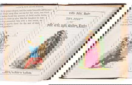
Children's.- Chatelain (Clara de) Little Folks' Books, 13 vol. in 1, hand-coloured illustrations,Forum Auctions4.3(53)See Sold PriceFeb 29, 2024
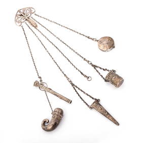
A vintage Chatelaine together with bangles, necklaces, pendants etc (Qty)Hannam's Auctioneers Ltd4.3(391)See Sold PriceMar 01, 2024
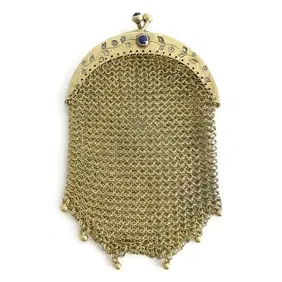
Victorian Antique Chatelaine Mesh Chain Mail Coin Purse 20K Yellow Gold 28.11 GrJasper524.5(9.8k)See Sold PriceFeb 27, 2024
Antique Franklin Lunt Chatelaine Seventy Six Piece Sterling Silver Flatware SetEric's Estate & Jewelry4.6(508)See Sold PriceFeb 25, 2024
Antique Franklin Lunt Chatelaine Seventy Six Piece Sterling Silver Flatware SetEric's Estate & Jewelry4.6(508)See Sold PriceFeb 24, 2024
SoldCHATELAIN, HENRI. Carte Particuliere du FleuveCHATELAIN, HENRI. Carte Particuliere du Fleuve Saint Louis. Double-page engraved map, 375x465 mm, wide margins; few short marginal tears. Kershaw I:307. Paris, 1719 or 1730 with--Group of 3 double-pagSee Sold Price
Sold* CHATELAIN, Henri Abraham (1684-1743). Carte* CHATELAIN, Henri Abraham (1684-1743). Carte Particuliere du Fleuve Saint Louis. Dressee sur les Lieux avec les Noms des Sauvages du Pais. [Amsterdam: ca 1719 or later]. Engraved map of the Great LakSee Sold Price
[maps] Chatelain, Carte du fleuve Saint LouisHenri Abraham Chatelain, Carte particuliere du fleuve Saint Louis dressee sur les lieux avec les noms des sauvages du pais. 1708-1721. Incisione in rame. mm 367x460. Foglio: mm 445x550. Titolo imSee Sold Price
SoldChatelain, Henri Abraham - Carte géographique fleuveChatelain, Henri Abraham (1684-1743) Carte géographique fleuve Saint Louis (Saint Laurent) (1719) Gravure sur papier marouflée sur carton, titrée Carte particuliere du fleuve Saint louis dresSee Sold Price
1719 Carte Particuliere du Fleuve Saint Louis DresseeThis is an authentic antique map of French Canada, and the Great Lakes region from just west of the Mississippi to the Atlantic. The map was created by Henri Chatelain as part of his 7 volume atlas anSee Sold Price
1719 Carte Particuliere du Fleuve Saint Louis DresseeThis is an authentic antique map of French Canada, and the Great Lakes region from just west of the Mississippi to the Atlantic. The map was created by Henri Chatelain as part of his 7 volume atlas anSee Sold Price
Chatelain Map of the Great Lakes, 17201720 Chatelain Map of the Great Lakes - Carte Particuliere Du Fleuve Saint Louis Dressee Sur Les Lieux Avec Les Noms Des Sauvages Du Pais…. Map of Canada, the Great Lakes and the Course of the MissiSee Sold Price
Sold1720 Chatelain Map of the Great Lakes Reproduction1720 Chatelain Map of the Great Lakes Reproduction - Carte Particuliere Du Fleuve Saint Louis Dressee Sur Les Lieux Avec Les Noms Des Sauvages Du Pais… H. Chatelain 1720 Amsterdam 14 x 18 in. Map ofSee Sold Price
SoldCHATELAIN, HENRI. Carte du Canada ou de la NouCHATELAIN, HENRI. Carte du Canada ou de la Nouvelle France. Double-page engraved map, 410x530 mm, wide margins; a nice dark impression. Amsterdam, 1719 "Chatelain's map of Canada is closely derived frSee Sold Price
Sold18TH CENTURY GREAT LAKES REGION HAND-COLORED MAP,18TH CENTURY GREAT LAKES REGION HAND-COLORED MAP, "Carte Particuliere Du Fleuve Saint Louis Dressee Sur Les Lieux Avec les noms des Sauvages du Pais, des Marchandises Qu'on Y Porte & Qu'on en Recoit",See Sold Price
MAP, Western South America, ChatelainWestern South America, Peru. Henry Abraham Chatelain, Carte Particuliere du Perou, Plan de la Ville de Lima, Description de Quelques Plantes, Animaux, & Machines du Pays. Avec l'Habillement des HommesSee Sold Price
SoldMAPS - [CHATELAIN, Henri Abraham]. Carte du GouveMAPS - [CHATELAIN, Henri Abraham]. Carte du Gouvernemente de l'Amerique.[Amsterdam or Paris: c. 1720]. Double-page engraved map from Atlas Historique (530 x 447 mm). Condition: browning and spSee Sold Price
SoldChatelain (Henri Abraham) Carte du CanadaChatelain (Henri Abraham) Carte du Canada ou de la Nouvelle France, from Greenland to Maryland, engraved map with original outline hand-colouring, and wash to the sea, 410 x 520mm., some discoSee Sold Price
Chatelain, Henri A. Carte du Paraguai, du Chili...Chatelain, Henri Abraham Carte du Paraguai, du Chili, du Detroit de Magellan... 1713 Copperplate engraving; old coloured Printed area: 51 x 40 cm; 20 x 15.7 in Detailed map of the southern part of SouSee Sold Price
Chatelain, HA. Carte du Canada ou de la Nouvelle FranceChatelain, Henri Abraham Carte du Canada ou de la Nouvelle France... 1718 Copperplate engraving; coloured Printed area: 53 x 41.5 cm; 20.9 x 16.3 in An important map in the history of Canada from theSee Sold Price
SoldChatelain (H. A.) Map of BohemiaChatelain (Henri Abraham) Carte du Royaume de Boheme. La Chronologie De Ses Rois. Les Etats de Silesie, Moravie, et Lusace,showing part of the Czech Republic and parts of Hungary and Austria,See Sold Price
Chatelain, HA. Carte du Canada ou de la Nouvelle FranceChatelain, Henri Abraham Carte du Canada ou de la Nouvelle France 1719 Copperplate engraving; area coloured Printed area: 52 x 40.5; 20.5 cm x 16 in Chatelain's map of Canada & the Great Lakes was theSee Sold Price
SoldChatelain. Carte......de MoscovieChatelain (Henri Abraham) Carte du Gouvernement Civil et Eclesiastique de Moscovie,city plan of Moscow, upper left, large Imperial arms surrounded by smaller provincial arms, upper centre, andSee Sold Price
SoldChatelain (H.A.) Carte du Plan de VeniseChatelain (Henri Abraham) Carte du Plan de Venise, l'État de sa Noblesse, et ses differens degrez, avec quelques autres remarques curieuses sur cette superbe ville,bird's-eye plan-view of VeniSee Sold Price
Sold(Maps and Charts, Italy), Chatelain, Henri Abraham(Maps and Charts, Italy), Chatelain, Henri Abraham, Carte du plan de Venise, [Amsterdam, c. 1721 or later], double page folio, matted, unframed, 21 5/8 x 17 5/8 in., (light toning and smudging, lowerSee Sold Price
Chatelain (H.A.) Nouvelle Carte... de LondresChatelain (Henri Abraham) Nouvelle Carte du Gouvernement Civil d'Angleterre; Nouvelle Carte d'Ecosse,the former of England and Wales, with two allegorical scenes in upper corners, and centralSee Sold Price
SoldChatelain (H.A.) Nouvelle Carte... de LondresChatelain (Henri Abraham) Nouvelle Carte du Gouvernement Civil d'Angleterre et de Celuy de la Ville de Londres,central plan of London, map of England and Wales above, two allegorical scenes inSee Sold Price
SoldEngland and Wales.- Chatelain (Henri Abraham) NouvelleEngland and Wales.- Chatelain (Henri Abraham) Nouvelle Carte du Gouvernement Civil d'Angleterre et de Celuy de la Ville de Londres, folio sheet containing a map of England and Wales, a plan of London,See Sold Price
Sold[Chatelain (Henri Abraham)] British Isles[Chatelain (Henri Abraham)] Nouvelle Carte du Gouvernement Civil d'Angleterre et de Celuy de la Ville de Londres,British Isles, plan of London, and 2 vignette scenes, engraved sheet with hand-See Sold Price
LARGE EARLY 18TH C. DUTCH CHART OF UPPER NORTH AMERICA, PIERRE MORTIER (1661-1711), FRAMEDThomaston Place Auction Galleries4.4(389)See Sold PriceFeb 24, 2024
Henri Matisse - Paysage du loup from"XX Siecle No .4"Dane Fine Art Auctions4.4(496)See Sold PriceMar 07, 2024
[MAPS]. DUFOUR, Auguste-Henri (1795-1865). Bound Volume of ...Potter & Potter Auctions4.6(544)See Sold PriceMar 07, 2024
1760 MAP CARTE PARTICULIERE DE L'ISLE DE JUAN FERNANDES antique Robinson CrusoeJasper524.5(9.8k)See Sold PriceFeb 27, 2024
1764 Bellin Chart of Three South Haitian Bays -- Carte des Bayes du Mesle des Flamands et deJasper524.5(9.8k)See Sold PriceFeb 27, 2024
Carte du Canal de Mosambique…. Madagascar Bonne Esperance. BONNE 1780 mapJasper524.5(9.8k)See Sold PriceFeb 28, 2024
Carte du Golfe de Guinée'. Gulf of Guinea. Nigeria & Cameroon. BELLIN 1747 mapJasper524.5(9.8k)See Sold PriceFeb 28, 2024
Côte occidentale de l'Afrique. W Africa.Senegal Gambia rivers.D’ANVILLE 1751 mapJasper524.5(9.8k)See Sold PriceFeb 28, 2024
Carte du Golfe de Guinée. Gulf of Guinea Nigeria Cameroon BELLIN/SCHLEY 1748 mapJasper524.5(9.8k)See Sold PriceFeb 28, 2024


![[maps] Chatelain, Carte du fleuve Saint Louis (1 of 1)](https://p1.liveauctioneers.com/1306/122788/62497201_1_x.jpg?height=282&quality=70&version=1527839290)


![MAPS - [CHATELAIN, Henri Abraham]. Carte du Gouve (1 of 1)](https://p1.liveauctioneers.com/839/16941/5652907_1_x.jpg?height=282&quality=70&version=1221072577)


![[Chatelain (Henri Abraham)] British Isles (1 of 0)](https://p1.liveauctioneers.com/dist/images/placeholder.jpg?height=282&quality=70)


![[MAPS]. DUFOUR, Auguste-Henri (1795-1865). Bound Volume of ... (1 of 2)](https://p1.liveauctioneers.com/928/318880/171361279_1_x.jpg?height=282&quality=70&version=1707501302)


