SoldMap of Paris by Guillaume De L'Isle, entitled PlanMap of Paris by Guillaume De L'Isle, entitled Plan de La Ville et Faubourgs de Paris, published in Paris, c. 1716 or later, double-page folio with hand coloring to borders, framed, sight size 20 1/2 xSee Sold Price
Sold[PARIS] -- DE LISLE, Guillaume (1675-1726). Le Plan de[PARIS] -- DE LISLE, Guillaume (1675-1726). Le Plan de Paris, ses Faubourgs et ses Environs|Platte Grond van Parys, zyn Voorburgen en Omleggende Plaatse. Amsterdam: Covens & Mortier, ca 1730. EngravedSee Sold Price
De l'Isle and Buache. Atlas GéographiqueDe l'Isle (Guillaume) and Phillipe Buache. Atlas Géographique des Quatre Parties du Monde,engraved title and contents leaf, 37 maps (including double-hemisphere world, and plan of Paris) withSee Sold Price
A Seminal map of Canada, which first appeared in 1703Carte du Canada ou de la Nouvelle France... Guillaume Del'Isle. Engraved map. Paris: Chez L'Auteur, 1703. 20 1/4 x 26 1/4 inches visible, 30 1/2 x 36 3/4 inches framed. One of the seminal maps of CanaSee Sold Price
SoldDeLisle Map of New Canada, 1703 1st EditionDE L'ISLE, Guillaume (1675-1726). Carte du Canada ou de la Nouvelle France... Engraved map with original hand color in outline. Paris: Guillaume De L'Isle, Rue de Cannettes, 1703 [First Issue]. 20 3/8See Sold Price
De L'Isle Map of Canada 1703 First StateDE L'ISLE, Guillaume (1675-1726).Carte du Canada ou de la Nouvelle France...Engraved map with original hand color in outline.Paris: Guillaume De L'Isle, Rue de Cannettes, 1703 [First Issue].19 1/4" xSee Sold Price
De L'Isle Map of Gulf of MexicoDE L'ISLE, Guillaume (1675-1726).Carte du Mexique et de la Floride.Engraved map with original hand color in outline.Paris: Guillaume De L'Isle, Rue de Cannettes, 1703 [First Issue].20 1/8" x 28 3/8" sSee Sold Price
SoldGuillaume de l'Isle HAND-COLORED ENGRAVED MAP PARISGuillaume de l'Isle HAND-COLORED ENGRAVED MAP PARIS c1733 France Covens Mortier Amsterdam Brie Hurepois Beauce Normandie Chartrain Gastinois Guillaume de l'Isle HAND-COLORED ENGRAVED MAP PARIS c1733 FSee Sold Price
SoldCarte du Mexique et de la Floride des Terres AngloisesGuillaume De l’Isle (1675 - 1726). Paris: Guillaume De l’Isle, 1703. 20 x 27 inches. Guillaume de L’Isle’s Seminal Map of Florida and MexicoSee Sold Price
SoldDe L'Isle Engraved Map of CanadaCarte du Canada ou de la Nouvelle France. Guillaume De L’isle (1675-1726). Engraved Map. Paris, Quai de LÂ’Horloge, 1703. 20 x 26 3/4 inches sheet, 31 1/2 x 38 1/2 inches framed. "Del'Isle's mapSee Sold Price
SoldDelisle Map of AmericaDELISLE, Guillaume (1675 - 1726). L'Amerique Septentrionale. Engraved map.Paris: 1700. 19 3/4" x 23" sheet.Guillaume De L'Isle's Highly Important Map of North America.This historically important foundSee Sold Price
Sold1700 GUILLAUME DE L'ISLE SOUTH AMERICA MAPde L'ISLE, Guillaume, (French, 1675-1726): L'Amerique Meridionale. Dressee sur les observations de Mrs. de l'Academie Royales. Paris, 1700, map. Copper engraving, 18'' x 24'', hand colored in outline.See Sold Price
SoldA Large 18th Century Map of Poland,published in Paris, C.1738, Guillaume De l'Isle's (1675-1726), cartouche reads 'La Pologne. Chez l’Auteur sur le Quai de l’Horloge a la C. ne de Diamãs. Avec Privilege du Roy, et se tSee Sold Price
SoldDe L'Isle, Carte Du Paraguay Du Chili, 1745.[South America]. Guillaume De L'Isle. Carte Du Paraguay Du Chili Du Detroit de Megellan &c. Double-page engraved map engraved by Liebaux. Paris: Quai du l'Horlage, 1703 [1745]. Lower right corner, ''PSee Sold Price
SoldClaude De L'Isle Map of Paris 1720Claude De L'Isle (1644 -1720), "Plan de la Ville et Fauxbourgs de Paris," Paris, 1720. A wonderful French map of Paris, highlighting many wonderful modern locations including Notre Dame cathedral, theSee Sold Price
Guillaume de l’Isle, Map of the Modern World, Paris,Guillaume de l'Isle (1675-1726) – French cartographer in services of King Louis XIV. 'Nova orbis tabula ad Usum Serenißim Burgundiae Ducis - Mappe Monde Dreßé sur les observations de M. de L`AcadSee Sold Price
SoldTwo Maps of the Holy LandLot of two maps of the Holy Land: *"Terrae Sanctae 2". Copperplate engraving. Paris: Lattre & Delalain,1782. Authors: Guillaume de l'Isle and Joseph Nicolas de l'Isle. Dimensions of plate: 34X48.5 cm.See Sold Price
Historical map of Greece, ''GraeciaHistorical map of Greece, ''Graeciae pars septentrionalis'', col. Engraving by Guillaume de L'Isle, Paris 1708, sheet dimensions 56 x 74 cmSee Sold Price
SoldDe L'Isle Engraved Map of the AmericasCarte d'Amerique dressée pour l'usage du Roy. Guillaume De L'Isle (1675-1726) & Philippe Buache (1700-1773). Engraved map with hand color in part. Paris, 1722 (1763). 21 1/2 x 27 3/4 inches sheetSee Sold Price
SoldDe L'isle, Map of ArabiaCarte du la Turquie de l'Arabie et du la Perse... Guillaume De L'Isle (1675-1726). Engraved map with hand color in outline. Paris, 1780. 21 1/2 x 27 3/4 inches sheet. This is a foundational map and maSee Sold Price
SoldLARGE 18TH CENTURY MAP OF CAUCUSESA 1723 DE L'ISLE MAP OF THE CAUCUSES AND THE CASPIAN SEA. Comprising an 18th century map entitled "Carte Des Pays Voisins De La Mer Caspiene" by French Cartographer Guillaume De L'isle. The map displSee Sold Price
De L'isle, Map of Biblical Asia MinorTheatrum historicum ad annum Christi quadringentesimi in quo tu Imperii Romani tu Barbarorum... Guillaume De L'Isle (1675-1726). Engraved map with original color in outline. Paris, 1705. 20 x 26 3/4 iSee Sold Price
SoldAn 18th Century Map of Poland,Guillaume De L'Isle, published paris, c.1702, with cartouche which reads 'La Pologne Dressee sur ce qu'en ont donne Starovolsk, Beauplan, Hartnoch . . .', copper engraving, uncoloured, verso plane, diSee Sold Price
DE L'ISLE, Guillaume. Carte d'Amerique.DE L'ISLE, Guillaume. Carte d'Amerique.Paris: [c.1705]. Double-page engraved map, hand-colored. 19 x 24 in. Condition: wide margins, small inked stamp on verso. A fine, dark impression withSee Sold Price
[MAPS]. DUFOUR, Auguste-Henri (1795-1865). Bound Volume of ...Potter & Potter Auctions4.6(539)See Sold PriceMar 07, 2024
Map of St. Kitts and Nevis Depot de la Marine, Paris, 1758Global Auctions Company4.3(36)See Sold PriceMar 03, 2024
Chatelain - Map of the Americas and Details and Insets of Government CounselsTrillium Antique Prints & Rare Books4.5(30)See Sold PriceFeb 24, 2024
Chatelain - 3 Maps of the British Isles (England, Ireland, Scotland)Trillium Antique Prints & Rare Books4.5(30)See Sold PriceFeb 24, 2024
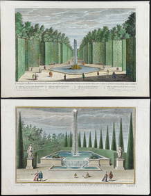
Demortain - 4 Fountain & Garden EngravingsTrillium Antique Prints & Rare Books4.5(30)See Sold PriceFeb 24, 2024
1760 MAP CARTE PARTICULIERE DE L'ISLE DE JUAN FERNANDES antique Robinson CrusoeJasper524.5(9.8k)See Sold PriceFeb 27, 2024
1764 Bellin Map of Mari-Galante Near Guadeloupe -- Carte de l'Isle de Mari-GalanteJasper524.5(9.8k)See Sold PriceFeb 27, 2024
1764 Bellin Map of St. Kitts -- Carte de l'Isle St. ChristopheJasper524.5(9.8k)See Sold PriceFeb 27, 2024
1764 Bellin Map of Antigua -- Carte de l'Isle d'Antigue Situee par la Latitude 17 Degres et par laJasper524.5(9.8k)See Sold PriceFeb 27, 2024
1845 Delisle/Bauche Map of Martinique -- Carte de l'Isle de la Martinique Colonie Francoise de l'uneJasper524.5(9.8k)See Sold PriceFeb 27, 2024
Le Canal de Mosambique, l'Isle de Madagascar… Mozambique. Africa. BONNE 1788 mapJasper524.5(9.8k)See Sold PriceFeb 28, 2024
Le Canal de Mosambique, l'Isle de Madagascar… Mozambique. Africa. BONNE 1790 mapJasper524.5(9.8k)See Sold PriceFeb 28, 2024
Barthelemy, Jean 1790 Map. Greece - Essa sur la Bataille de PlateeAlbion Auctions4.6(336)See Sold PriceMar 01, 2024
Barthelemy, Jean 1790 Map. Greece - Plan de L'AcademieAlbion Auctions4.6(336)See Sold PriceMar 01, 2024
Barthelemy, Jean 1790 Map. Greece - Essai sur les Environs de DelphesAlbion Auctions4.6(336)See Sold PriceMar 01, 2024
Poster "Les jardins de Paris", illustrated map and plan of Paris with its parcs, gardens, monuments,Proverde Auctions4.3(3)See Sold PriceFeb 28, 2024
Map of the Count of Flanders, 1700 by Gillaume de Lisle, ParisAntiques Online Auctions4.6(407)See Sold PriceMar 14, 2024
Map of Turkey from Arabic and Persia, 1701 by Gillaume de Lisle, ParisAntiques Online Auctions4.6(407)See Sold PriceMar 14, 2024
Antique Map of Poland, 1700 by Guillaume De Lisle, ParisAntiques Online Auctions4.6(407)See Sold PriceMar 14, 2024


![[PARIS] -- DE LISLE, Guillaume (1675-1726). Le Plan de (1 of 1)](https://p1.liveauctioneers.com/197/200856/101675759_1_x.jpg?height=282&quality=70&version=1618510789)


![[MAPS]. DUFOUR, Auguste-Henri (1795-1865). Bound Volume of ... (1 of 2)](https://p1.liveauctioneers.com/928/318880/171361279_1_x.jpg?height=282&quality=70&version=1707501302)