SoldMap of Nice, France,"[Le vray Pourtraiet de la Ville & Chateau de Nice, 1576",] bird's-eye view perspective, copper engraving on laid paper with two script watermarks, maker unknown, probably a 19th century printing, FreSee Sold Price
SoldWWII SOUTHERN FRANCE TOP SECRET BIGOT NICE MAPWWII SOUTHERN FRANCE TOP SECRET BIGOT NICE MAP From Rear Admiral George B.H. Stallings Archive; WWII US Armed Forces, Southern France, Top Secret Bigot map, Coast Defense Batteries, Guns Peninsula toSee Sold Price
Sold1831 Teesdale Map of France -- FranceTitle: 1831 Teesdale Map of France -- France Date: 1831, London Cartographer: H Teesdale Size: 13.2 X 16.1 in. Additional Information: This is a very nice and detailed map of northern Italy, just pastSee Sold Price
SoldSANSON, N. Le Canada, ou Nouvelle France, 1656Sanson, N. LE CANADA, OU NOUVELLE FRANCE. Paris Pierre Mariette, 1656. Engraved map hand coloured in outline, generally a nice, clean impression, framed. 39.5 x 54 cm (mark).See Sold Price
SoldAntique Map Bay of Biscay France, 1833Beautiful early hand colored map in a 24" by 20" frame. Nice details and toning. ExcellentSee Sold Price
SoldFRANCE in Provinces wiithout Comté de Nice &TITLE/CONTENT OF MAP: 'France' Shows France in provinces without the County (Comte) de Nice of the Duchy of Savoy (Savoie) prior to the 1860 Treaty of Turin when these territories were ceded to FranceSee Sold Price
SoldBowen: Antique Map of France, 1768Title/Content of Map: 1768 Bowen Map of France -- A New and Correct Map of France Drawn from the latest Authorities Date Printed: 1768 c. Cartographer: T Bowen Size: 14.3 x 9.3 in. Condition: Fair. NiSee Sold Price
SoldRare map of Provence, France, with multiple city views.Title/Content of Map: Rare map of Provence, France, with multiple city views. Including Avignon, Nice, Marseille Date: 1717 Cartographer: Feuille Size: 7.6x10.6” Provenance: Amsterdam Original hanSee Sold Price
Map of France in Provinces"France in provinces", before the Revolution, without Savoy & Nice. THOMSON 1817 map Size: Approx 53.0 x 63.0cm, 20.75 x 24.75 inches (Large); Please note that this is a folding map. Please note thatSee Sold Price
SoldGerard Valck map of FranceCartographer: Gerard Valck Title: Provincia . Gouvernment de Provence Subject: France Published: Amsterdam Date: c. 1702 Description: In addition to showing cities such as Toulon, Antibes, and Nice onSee Sold Price
Gerard Mercator: Pedemontana Regio 1608Map: Pedemontana Regio, cum Genuensium territ (Map of the southern Mediterranean coast of France and part of Italy's Piedmont region, including Nice, Monaco and Genoa) Maker: Gerard Mercator PublishinSee Sold Price
SoldNice France Signed Impressionist Cityscape Framed Oil PaintingAntique French impressionist cityscape painting. Oil on canvas. Signed. Framed. Image size, 24L x 20H.See Sold Price
SoldGallia Color Map [France]Galliae Regni Potentiss Color Map with written description in Latin on verso. Map of France with boarders to Germany, Spain and Italy. Appears to be a page from an atlas. Undated. Measures 14 in. x 20See Sold Price
SoldPair Elie Bernadac oil ptgs of Nice, FranceArtist: Bernadac, Elie (1913 - 1999) Title: Martigues Coup de Soleil & Provence (#461)- Vielle Fontainie a Lines (#381) Date: circa 1955 Medium: oil on canvas Dimensions: 13 x 16 inches DescSee Sold Price
SoldJean Jolivet Map, FranceGalliae Regni Potentiss", hand colored engraving by Jean Olivet, with text verso. Toning, spotting, tears, pencil marks at the lower right, other wear. 18.5" x 23See Sold Price
SoldLevasseur, Victor 1869 Lot 6 HC Decorative Maps FranceHand Colored Steel Engraved Decorative Map Published C1850, Paris for "Atlas National Illustre" by Victor Levasseur. Paper Size: 20.5 x 14.5 inch (52 x 37cm) Good ConditionSee Sold Price
SoldLevasseur, Victor 1869 Lot 6 HC Decorative Maps FranceHand Colored Steel Engraved Decorative Map Published C1850, Paris for "Atlas National Illustre" by Victor Levasseur. Paper Size: 20.5 x 14.5 inch (52 x 37cm) Good ConditionSee Sold Price
SoldWWII D-DAY TOP SECRET MAP FRANCE NORTH COASTWWII D-DAY TOP SECRET MAP FRANCE NORTH COAST From Rear Admiral George B.H. Stallings Archive; WWII US and British Armed Forces, Top Secret British map of France North Coast, Cape Levi to Fecamp. RearSee Sold Price
Sold[Map] France, 1586"Nouvelle Description Du Royaulme De France." Paris, par Francois de Gourmont, 1586. Image including heading and lower caption measures 497 x 383mm ( 19.5" x 15"). Several short marginal tears, one piSee Sold Price
SoldYoshio Aoyama Oil on Canvas of Nice FranceYoshio Aoyama (Japanese, 1894-1996), Nice, France, oil on canvas, 18" x 22 1/2", frame 25 1/2" x 29".See Sold Price
Henri Matisse - Travel Poster: Nice, FranceHenri Matisse -"Travail & Joie" travel poster for Nice, France. The lithograph measures 12.75" x 9.5" and features the image of Matisse's "Nature Morte aux Grenades" (Still Life With Pomegranates.)See Sold Price
Henri Matisse - Travel Poster: Nice, FranceHenri Matisse -"Travail & Joie" travel poster for Nice, France. The lithograph measures 12.75" x 9.5" and features the image of Matisse's "Nature Morte aux Grenades" (Still Life With Pomegranates.)See Sold Price
SoldLevasseur, Victor 1869 Lot 6 HC Decorative Maps FranceHand Colored Steel Engraved Decorative Map Published C1850, Paris for "Atlas National Illustre" by Victor Levasseur. Paper Size: 20.5 x 14.5 inch (52 x 37cm) Good ConditionSee Sold Price
Crams Map of North Dakota-Complete Railroad System and County Map-1907JM Hobby Supply and Railroad Artifact Auctions4.4(126)See Sold PriceFeb 24, 2024
Attributed to Johannes (Jan) Tielius (Netherlands/France 1660-1719)Nadeau's Auction Gallery4.7(401)See Sold PriceFeb 24, 2024
1901 Pretoria South Africa Boer War Censored Cover To Nice FranceMynt Auctions4.6(680)See Sold PriceFeb 24, 2024
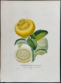
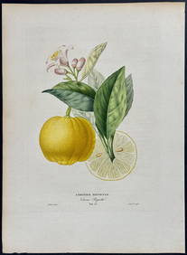
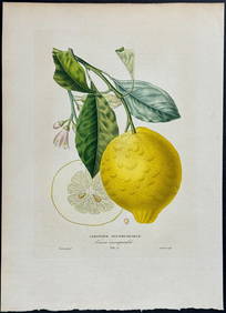
Risso - Lemon or Citrus Fruit. 73Trillium Antique Prints & Rare Books4.5(30)See Sold PriceFeb 24, 2024
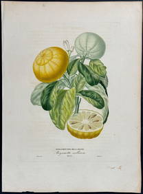
Risso - Lemon or Citrus Fruit. 71Trillium Antique Prints & Rare Books4.5(30)See Sold PriceFeb 24, 2024
1764 Bellin Chart of Three South Haitian Bays -- Carte des Bayes du Mesle des Flamands et deJasper524.5(9.8k)See Sold PriceFeb 27, 2024
Antique Map of France, 1703 by Gillaume Del Isle PrintAntiques Online Auctions4.6(407)See Sold PriceMar 14, 2024
Galliae Regionis Nova Descriptio Hand Colored Map of France on Laid Paper, Ca. 16th Century, H 10" WDuMouchelles4.6(825)See Sold PriceMar 15, 2024


![Gallia Color Map [France] (1 of 6)](https://p1.liveauctioneers.com/5755/154409/77936853_1_x.jpg?height=282&quality=70&version=1573094011)


![[Map] France, 1586 (1 of 4)](https://p1.liveauctioneers.com/3532/111460/57224350_1_x.jpg?height=282&quality=70&version=1509131847)