KONVOLUT AUS VIER LANDKARTEN RUSSLAND UND CHINA Abraham Ortelius, Willem Blaeu, Johannes Blaeu,Hargesheimer Kunstauktionen Duesseldorf4.5(136)See Sold PriceMar 09, 2024
Sold1573 Ortelius Map of French Riviera and Italy'sTitle/Content of Map: 1573 Ortelius Map of French Riviera and Italy's Piedmont Region -- Pedemontanae Vicinorumque Regionum Auctore Iacobo Castaldo Descrip Date Printed: 1573, Antwerp Cartographer: ASee Sold Price
1602 Ortelius Map of French Riviera's Western Portion -- LanguedocTitle: 1602 Ortelius Map of French Riviera's Western Portion -- Languedoc Cartographer: A Ortelius Year / Place: 1602, Antwerp Map Dimension (in.): 3 X 4.2 in. This is a lovely smaller map of southernSee Sold Price
1602 Ortelius Map of French Riviera's Western PortionTitle: 1602 Ortelius Map of French Riviera's Western Portion -- Languedoc Cartographer: A Ortelius Year/Place: 1602, Antwerp Dimensions: 3 X 4.2 in. Description: This is a lovely smaller map of southeSee Sold Price
MAP - Italy & Slovenia. OrteliusNortheastern Italy & Western Slovenia. Abraham Ortelius, Fori Iulii Accurata Descriptio, 1573 (dated). Hand Color. Fine map covers the region from Venice north to the Italian Alps and east to TriesteSee Sold Price
SoldOrtelius, "Fori Iv Lii Accv Ralta De Scripto", EngravedAbraham Ortelius (Belgian, 1528-1598), "Fori Iv Lii Accv Ralta De Scripto," hand colored engraved map, dated 1573, map of Friuli, Italy, 13 3/4" h x 18 1/2" w (view), 21 1/2" h x 25 1/2" w (frame). PrSee Sold Price
1573 Ortelius Map of Six Mediterranean Islands --Title/Content of Map: 1573 Ortelius Map of Six Mediterranean Islands -- Insularum Aliquot Maris Mediterranei Descriptio Date: 1573 c., Antwerp Cartographer: A Ortelius Size: 14.9 X 18.7 in. This is anSee Sold Price
1573 Ortelius Map of Six Mediterranean Islands --Title/Content of Map: 1573 Ortelius Map of Six Mediterranean Islands -- Insularum Aliquot Maris Mediterranei Descriptio Date: 1573 c., Antwerp Cartographer: A Ortelius Size: 14.9 X 18.7 in. This is anSee Sold Price
Sold1573 Ortelius Map of Six Mediterranean Islands --Title: 1573 Ortelius Map of Six Mediterranean Islands -- Insularum Aliquot Maris Mediterranei Descriptio Date: 1573 c., Antwerp Cartographer: A Ortelius Size: 14.9 X 18.7 in. Additional Information: TSee Sold Price
1573 Ortelius Map of Six Mediterranean Islands --Title/Content of Map: 1573 Ortelius Map of Six Mediterranean Islands -- Insularum Aliquot Maris Mediterranei Descriptio Date: 1573 c., Antwerp Cartographer: A Ortelius Size: 14.9 X 18.7 in. This is anSee Sold Price
Sold1598 Ortelius Map of Italy -- Italiae NovissimaTitle/Content of Map: 1598 Ortelius Map of Italy -- Italiae Novissima Descriptio Auctore Iacobo Castaldo Pedemontano Cartographer: A Ortelius Year/Place: 1598, Antwerp Size: 13.8 X 19.7 in. This is aSee Sold Price
Sold1602 Ortelius Map of Italy's Lake Garda Area --Title: 1602 Ortelius Map of Italy's Lake Garda Area -- Bresciano Cartographer: A Ortelius Year/Place: 1602, Antwerp Dimensions: 3 X 4.2 in. Description: This is a lovely smaller map of Italy's LombardSee Sold Price
1598 Ortelius Map of Italy -- Italiae NovissimaTitle/Content of Map: 1598 Ortelius Map of Italy -- Italiae Novissima Descriptio Auctore Iacobo Castaldo Pedemontano Cartographer: A Ortelius Year/Place: 1598, Antwerp Size: 13.8 X 19.7 in. This is aSee Sold Price
1598 Ortelius Map of Italy -- Italiae NovissimaTitle/Content of Map: 1598 Ortelius Map of Italy -- Italiae Novissima Descriptio Auctore Iacobo Castaldo Pedemontano Cartographer: A Ortelius Year/Place: 1598, Antwerp Size: 13.8 X 19.7 in. This is aSee Sold Price
1602 Ortelius Map of Italy's Marche Region -- MarcaTitle: 1602 Ortelius Map of Italy's Marche Region -- Marca Anconitana Cartographer: A Ortelius Year / Place: 1602, Antwerp Map Dimension (in.): 3 X 4.1 in. This is a lovely smaller map of the Marche rSee Sold Price
SoldABRAHAM ORTELIUS MAP OF ITALY.ABRAHAM ORTELIUS MAP OF ITALY. Inscribed "Italiae Novissima Descriptio Auctore Iacobo Castaldo Pedemontano". Together with two handcolored prints after Giuseppe Zocchi showing two scenes in Italy. AllSee Sold Price
SoldOrtelius Map of French BurgundyOrtelius Map of French Burgundy "Burgundiae Comitatus Recentiss Descriptio Dno Ferdinando Lannoyo auctore," unsigned, by Flemish cartographer Abraham Ortelius (1527 - 1598) and dated 1579, published iSee Sold Price
1598 Ortelius Map of Italy -- Italiae NovissimaTitle/Content of Map: 1598 Ortelius Map of Italy -- Italiae Novissima Descriptio Auctore Iacobo Castaldo Pedemontano Date: 1598, Antwerp Cartographer: A Ortelius Size: 13.8 X 19.7 in. This is a superbSee Sold Price
A. ORTELIUS - MAP OF ITALY NEAR FLORENCEA. Ortelius - Map Of Italy Near Florence - 40 X 26 3/4 In. - This Giclée Print Is Gallery Stretched And Ready To Hang Or Lean Against A Wall, Or Display On An Easel. - A Giclée Print Is The HighestSee Sold Price
A. ORTELIUS - MAP OF ITALY NEAR FLORENCEA. Ortelius - Map Of Italy Near Florence - 44 X 29 1/2 In. - This Giclée Print Is Gallery Stretched And Ready To Hang Or Lean Against A Wall, Or Display On An Easel. - A Giclée Print Is The HighestSee Sold Price
A. Ortelius - Map Of Italy Near FlorenceA. Ortelius - Map Of Italy Near Florence Size: 36 X 24 1/8 In. - This Is A Gallery Stretched Giclee Print On Canvas. The Piece Was Printed On High Quality Artist Grade 350 Gsm, Acid-free, Archival CanSee Sold Price
A. ORTELIUS - MAP OF ITALY NEAR FLORENCEA. Ortelius - Map Of Italy Near Florence - 44 X 29 1/2 In. - This Giclée Print Is Gallery Stretched And Ready To Hang Or Lean Against A Wall, Or Display On An Easel. - A Giclée Print Is The HighestSee Sold Price
1602 Ortelius Map of Italy's Marche Region -- Marca AnconitanaTitle: 1602 Ortelius Map of Italy's Marche Region -- Marca Anconitana Cartographer: A Ortelius Year / Place: 1602, Antwerp Map Dimension (in.): 3 X 4.1 in. This is a lovely smaller map of the Marche rSee Sold Price
A. ORTELIUS - MAP OF ITALY NEAR FLORENCEA. Ortelius - Map Of Italy Near Florence - 44 X 29 1/2 In. - Giclée Print - Gallery Stretched - Ready to hang.See Sold Price
1602 Ortelius Map of Italy's Marche Region -- Marca AnconitanaTitle: 1602 Ortelius Map of Italy's Marche Region -- Marca Anconitana Cartographer: A Ortelius Year / Place: 1602, Antwerp Map Dimension (in.): 3 X 4.1 in. This is a lovely smaller map of the Marche rSee Sold Price
LATE 17TH C. FRENCH MAP OF THE NEW WORLD BY ALEXIS-HUBERT JAILLOT (1632-1712)Thomaston Place Auction Galleries4.4(389)See Sold PriceFeb 24, 2024
EARLY 18TH C. MAP OF ITALY, FRAMEDThomaston Place Auction Galleries4.4(389)See Sold PriceFeb 24, 2024
18TH C. ANTIQUE MAP: FRENCH & INDIAN WAR, FRAMEDThomaston Place Auction Galleries4.4(389)See Sold PriceFeb 24, 2024
ABRAHAM ORTELIUS (1527-1598) MAP OF ROMAN GAUL (FRANCE)Thomaston Place Auction Galleries4.4(389)See Sold PriceFeb 24, 2024
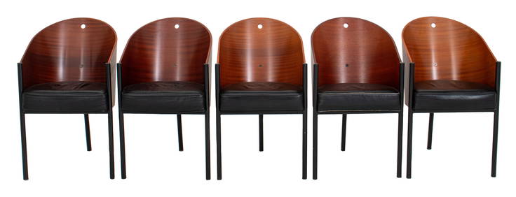
Philippe Starck x Aleph "Costes" Sapele Chairs, 5Auctions at Showplace4.6(731)See Sold PriceMar 03, 2024
French Riviera Cote d Azur Antibes Juan Les Pins Travel PosterHeritage Gallery Auctions4.4(56)See Sold PriceMar 10, 2024
Beautiful French style wall clock, Leore ItalySouth Jersey Auction by Babington Auction Inc4.6(123)See Sold PriceFeb 25, 2024
O De Garaven (France,early 20C) watercolor painting antiqueBroward Auction Gallery4.8(285)See Sold PriceMay 05, 2024
De Jode, Rare, pub. 1593 - Map of Africa (Africae Vera Forma, et Situs)Trillium Antique Prints & Rare Books4.5(30)See Sold PriceFeb 24, 2024
Louis Marcoussis (FRENCH / UNITED STATES / ITALY / POLAND, 1878 - 1941) pencil drawing on paperJoshua Kodner4.2(387)See Sold PriceMar 09, 2024