SoldJohnston (A.K.) The National AtlasJohnston (A.K.) The National Atlas,41 engraved maps with original hand-colouring in outline, complete but partially disbound, marginal surface dirt, publisher's half-morocco, worn, upper boardSee Sold Price
SoldJohnston (A.K.) The National AtlasJohnston (Alexander Keith) The National Atlas of Historical, Commercial and Political Georgraphy,Lithographic Edition, title and all 41 lithographed, double-page maps with original hand-colourSee Sold Price
SoldTWO ANTIQUE ENGRAVED MAPS OF RUSSIA 19TH CThe lot includes an antique map Russia in Europe by A.K. Johnston from the National Atlas, circa 1857, and Carte de la Russie d’Europe from the Atlas Universel, Paris, circa 1826. Dimensions: SSee Sold Price
MAP OF NORTH AMERICA BY A.K. JOHNSTONOriginal hand-colored lithographed map, 21 1/4' x 26', a depiction of North America removed from an edition of 'Johnston's National Atlas of Historical, Commercial, and Political Geography', publishedSee Sold Price
Johnston National Atlas 1843Johnston (Alexander Keith) The National Atlas of Historical, Commerical and Political Geography, engraved title and 46 maps and charts, hand-coloured in outline, first 6 maps with some staininSee Sold Price
SoldCartography12. Cartography.Group of 4 maps, as listed below. Various sizes; light wear. Vp, vd [75/100]Russia in Europe. Plate 21 of Johnston's National Atlas. 25-1/2 x 21 inches. 1850s * ditto. Plate 55 of MitcSee Sold Price
SoldJohnston, A.K., Royal Atlas of Modern Geography, 1861By Alexander Keith Johnston, Geographer to the Queen of Scotland, published by William Blackwood and Sons, 1861. Folio 20 x 14 inches, marbled endpapers, gold foredges. Detached boards, some loose pagSee Sold Price
SoldA. K. JOHNSTON 5 National Atlas Maps, [1860]A. K. JOHNSTON 5 National Atlas Maps, [1860] Hand-coloured map. Folio. Including North America, Canada, China, India, and Chart of the World. Some wear at folds, else good and clean. (5) large folioSee Sold Price
SoldJOHNSTON, A.K. PHYSICAL ATLAS OF NATURALJohnston, Alexander Keith. The Physical Atlas of Natural Phenomena, frontispiece and 24 coloured maps (occasional foxing and dust staining, mainly to margins), half calf (crack to spine), all edges giSee Sold Price
Atlases.- Johnston (A.K.) - The Physical Atlas of25 hand-coloured engraved maps including double-page frontispiece, ink signature at head of title, endpapers spotted, original cloth, rebacked and recornered in calf, Edinburgh & London, 1850 § BSee Sold Price
Johnston (A.K.) Handy Royal AtlasJohnston (Alexander Keith) Handy Royal Atlas of Modern Geography,title and 45 double-page maps, including North Polar Chart frontispiece, colour-printed wood-engraved maps, each c.340 x 430mm.See Sold Price
SoldAmerica.- Johnston (Alexander Keith) The National AtlasAmerica.- Johnston (Alexander Keith) The National Atlas of Historical, Commercial, and Political Geography, first edition, engraved title, 46 double-page engraved maps, hand-coloured in wash or outlinSee Sold Price
SoldAtlases.- Johnston (Alexander Keith) The National AtlasAtlases.- Johnston (Alexander Keith) The National Atlas of Historical, Commercial, and Political Geography, engraved title, 46 double-page engraved maps hand-coloured in outline, mounted on stubs, occSee Sold Price
SoldJohnston (Alexander Keith) - The National Atlas of41 double page hand coloured maps, contemporary half morocco, worn and damaged, folio, Cowan & Co., Edinburgh, [c.1843]See Sold Price
SoldJohnston's Atlas 1844 with 46 double-page mapsHeading: (Atlas) Author: Johnston, Alexander Keith Title: The National Atlas of Historical, Commercial and Political Geography, constructed from the most Recent and Authentic Sources Place Published:See Sold Price
SoldJohnston's Atlas 1843 with 41 double-page mapsHeading: Author: Johnston, Alexander Keith Title: The National Atlas of Historical, Commercial and Political Geography, constructed from the most Recent and Authentic Sources Place Published: EdinburSee Sold Price
Islands in the Pacific OceanTitle/Content of Map: Islands in the Pacific Ocean Date Printed: 1845 Cartographer: JOHNSTON, A. K. Size: 19.8X24 "by A. K. Johnston..." Plate 29, the National Atlas. Very detailed. Fine engraving. MaSee Sold Price
SoldWorld.- Johnston (W. & A.K.) The Handy Royal AtlasWorld.- Johnston (W. & A.K.) The Handy Royal Atlas,title, north polar chart frontispiece, and 52 double-page maps, colour-printed, occasional minor surface dirt, mostly marginal or on versos,See Sold Price
SoldAtlas. JOHNSTON (W & AK) lacking title, oblong 4to,Atlas. JOHNSTON (W & AK) lacking title, oblong 4to, with 31 only coloured maps backed on to linen, soiling and dust staining, worn binding (sold not subject to return)See Sold Price
SoldAntique Russia / Persia Maps1850 Copperthwait Russian Empire (14 x 17"). 1890s (?) Migeon / Moulin Vert Russian in Europe (20 1/2 x 15 1/2"). 1882 A.K. Johnston from World Atlas (21 x 26"). 1829 W. Darton Jun. Persian Empire (13See Sold Price
SoldJohnston (W. & A.K.) The Handy Royal AtlasJohnston (W. & A.K.) The Handy Royal Atlas,title, north polar chart frontispiece, and 52 double-page maps, colour-printed, occasional minor surface dirt, mostly marginal or on versos, publSee Sold Price
SoldLate 19th Century Cosmocgraphic Atlas published by W &Late 19th Century Cosmocgraphic Atlas published by W & A.K. Johnston, Edinburgh and London, together with an early 20th Century Stieler's Atlas with admiralty letter attached£0 - 0See Sold Price
ALEXANDER KEITH JOHNSTON, (Scottish, 1804-1871), NorthALEXANDER KEITH JOHNSTON (Scottish, 1804-1871) North America, National Atlas - 37, 1843 Hand colored engraved map By A. K. Johnston, F.R.G.S.; Edinburgh, John Johnstone and W. & A. K. Johnston. GlasgoSee Sold Price
SoldThe Handy Royal Atlas. JohnstonHeading: (Atlas) Author: Johnston, W. & A.K. Title: The Handy Royal Atlas Place Published: Publisher: Date Published: ca. 1910 Description: Approximately 50 color lithograSee Sold Price
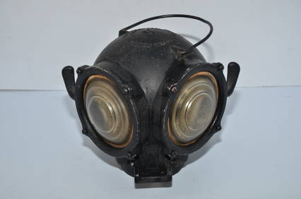
Pyle National Steam Locomotive Cannonball-Style Class LampJM Hobby Supply and Railroad Artifact Auctions4.4(126)See Sold PriceFeb 24, 2024
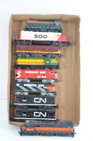
Nine Working GN/SOO/CNW/CP/CN/MILW DC Diesel Locomotives-HO ScaleJM Hobby Supply and Railroad Artifact Auctions4.4(126)See Sold PriceFeb 25, 2024
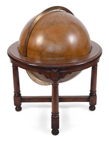
MONUMENTAL FLOOR-STANDING W. & A.K. JOHNSTON 30-INCH TERRESTRIAL GLOBE Edinburgh and London,Eldred's4.7(409)See Sold PriceFeb 28, 2024
ATLAS of ANTIENT GEOGRAPHY by SAMUEL BUTLER 1843John McInnis Auctioneers,LLC4.6(502)See Sold PriceFeb 24, 2024
[OCCUPATIONAL]. National Surety Medal for Valor presented to African American police officer LeslieFreeman's | Hindman4.4(1.6k)See Sold PriceFeb 27, 2024
Rare Model R-317 National Register From The Remington Arms Co.Ralph Fontaine Heritage Auctions Inc.4.7(235)See Sold PriceFeb 25, 2024
Model Train Sets in HO Scale, From Athearn, AHM, Atlas, and RoundhouseCain Modern Auctions4.4(44)See Sold PriceFeb 28, 2024
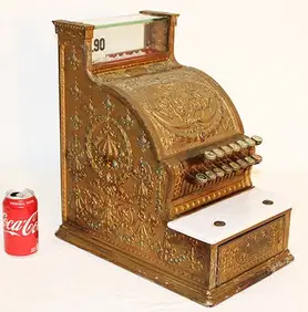
NATIONAL CASH REGISTER ESPLANADE HOTEL, SPRINGFIELD OHIO.Amelia Jeffers, Auctioneers & Appraisers4.6(101)See Sold PriceMar 08, 2024
Distressed New York & Great Northern O Scale BoxcarsRapid Estate Liquidators and Auction Gallery4.5(1.1k)See Sold PriceFeb 24, 2024
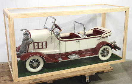
American National Lincoln tandem pedal carChupp Auctions & Real Estate, LLC4.6(244)See Sold PriceMar 23, 2024
MAGHREB. North Africa Morocco Algeria & Tunisia. JOHNSTON 1913 old antique mapJasper524.5(9.8k)See Sold PriceFeb 28, 2024
Afrique. Pays des Hottentots #50. Namibia South Africa VANDERMAELEN 1827 mapJasper524.5(9.8k)See Sold PriceFeb 28, 2024
COLONIAL CENTRAL AFRICA. Kenya Tanzania Belgian Congo Angola. JOHNSTON 1912 mapJasper524.5(9.8k)See Sold PriceFeb 28, 2024
COLONIAL CENTRAL AFRICA. Kenya Tanzania Belgian Congo Angola. JOHNSTON 1913 mapJasper524.5(9.8k)See Sold PriceFeb 28, 2024
WW2 WWII German Party National Banner with Maker MarkEagles Corps International LLC4.6(107)See Sold PriceMar 10, 2024
W.& A.K. Johnston (Scottish, Est. 1826) Terrestrial Globe on Kittinger Walnut Pedestal, Ca.DuMouchelles4.6(825)See Sold PriceMar 14, 2024


![A. K. JOHNSTON 5 National Atlas Maps, [1860] (1 of 1)](https://p1.liveauctioneers.com/1187/57305/28080900_1_x.jpg?height=282&quality=70&version=1403622104)


![[OCCUPATIONAL]. National Surety Medal for Valor presented to African American police officer Leslie (1 of 5)](https://p1.liveauctioneers.com/197/319238/171467942_1_x.jpg?height=282&quality=70&version=1707520367)