1 volume, Family Atlas with 80 maps, star maps by1 volume, Family Atlas with 80 maps, star maps by Sir J. LubbockSee Sold Price
Sold2V Decorative Gilt ANTIQUE FOLIO ATLASES Color Maps2V Decorative Gilt ANTIQUE FOLIO ATLASES Color Maps Diagrams statistics Illustrations Photographs Population Railroads Stars Constellations Economic Maps Cram’s Unrivaled Family Atlas of the WoSee Sold Price
SoldThe Sharples - Sharpless Family, Volumes 1, 2 & 3Bart Anderson "The Sharples - Sharpless Family, Volumes 1, 2 & 3" (West Chester 1966) From the Preface: "In 1816 the first history of the Sharples - Sharpless family was compiled and printed by JosephSee Sold Price
Sold(2) JOHNSON'S MAPS ,TEXAS, 1860, HEMISPHERES(lot of 2) Maps from Johnson's New Illustrated Family Atlas, 1860: (1) Johnson's New Map of the State of Texas, mat framed, in good condition with light original book fold, sight: 17.75"h, 24.5"w, oveSee Sold Price
ASTRONOMY CELESTIAL Star map chart signs 1 VernalTITLE/CONTENT OF MAP: '[STARS, I., Vernal Equinox]' Includes the astrological star signs for those born during the spring months: Pisces, Aquarius, Capricorn, Aries DATE PRINTED: 1874 IMAGE SIZE: ApprSee Sold Price
SoldLeather bindings, a large quantity includingLeather bindings, a large quantity including Burton, R. The Anatomy of Melancholy. 1806, 2 volumes, contemporary calf; McCulloch, J.R. A Dictionary... of Commerce. 1834. 1 volume in 2, folding maps, cSee Sold Price
Sold2 BOUND ATLASES FOR THE TOWN OF FALMOUTH, 1927.CLOTH BOUND. VOLUME 1 CONTAINS MAPS 1 - 30. VOLUME 2 CONTAINS MAPS 31 - 52. ATLASES SHOW WEAR. SOME CHIPPING TO PAGE ENDS. FOLDS AND CREASES TO FRONTIS PAGE. CHIPPING. THE NAME "PHINNEY" IS WRITTEN ONSee Sold Price
SoldMap of The Balkans, Romania, Serbia, Wallachia,Original colored, copper engraved map of Serbia, Bulgaria, Romania & Wallachia from volume 1 of Blaeu's "Theatrum Orbis terrarum, sive atlas novus", published in 1634. Map after Gerardius Mercator (15See Sold Price
SoldAlaska's Fisheries Atlas w/over 100 mapsHeading: (Alaska) Author: McLean, Robert F. and Kevin J. Delaney Title: Alaska's Fisheries Atlas, Volume 1 Place Published: [Juneau] Publisher:State of Alaska Dept. of Fish and Game Date PublisheSee Sold Price
Alaska's Fisheries Atlas w/over 100 mapsHeading: (Alaska) Author: McLean, Robert F. and Kevin J. Delaney Title: Alaska's Fisheries Atlas, Volume 1 Place Published: [Juneau] Publisher:State of Alaska Dept. of Fish and Game Date PublisheSee Sold Price
SoldJohn Charles Fremont Expeditions, 4 Books + MapsBooks and Maps: "The Expeditions of John Charles Fremont". Comprises three volumes in four hardcover books, plus the map portfolio in slipcase. Volume 1, (published 1971) Travels from 1838-1844, VolumSee Sold Price
SoldSir Charles Lyell "Travels In North America" Volume 1Sir Charles Lyell "Travels In North America" Volume 1 only (Wiley and Putnam, New York 1845); contemporary binding, worn and chipped, does not include any maps or color plates. From the Francis HopkinSee Sold Price
Sold"Narrative of a Voyage to the Polar Sea" 1878, Volume 1Captain Sir G.S. Nares "Narrative of a Voyage to the Polar Sea" Volume 1 only (Sampson Low, London 1878); fold-out map present but damaged. "O. Hopkinson" (Oliver Hopkinson 1812-1905) signed on titleSee Sold Price
SoldIn Darkest Africa by H.M. Stanley 1st Ed. w/ MapsIn Darkest Africa by H.M. Stanley 1st Ed. w/ Maps. Published by Schribner's Sons 1890. Volumes 1 and 2. Illustrated with wood-engravings & plates; steel-engraved frontispiece portraits; 4 folding mapsSee Sold Price
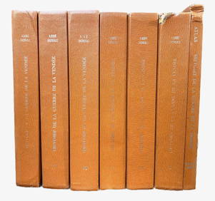
Sold5 History of Italy Books w/ MapsIncludes: 1) Studies in the History of Venice. Horatio F. Brown. John Murray. 1907. Volumes 1 and 2. 2) Geographical and Historical Description of Ancient Italy. Rev. J.A. Cramer. Clarendon Press. 182See Sold Price
SoldATLAS of BALTIMORE & ENVIRONSVolume #1, G. M. Hopkins 1876; (35) one page and two page color maps; binding broken, (1) torn, some small edge tears; 18" x 14", F-GSee Sold Price
Sold(REFERENCE.) Imago Mundi.(REFERENCE.) Imago Mundi. Volumes 1-58, plus Supplement I (Bagrow, Atlas of Siberia, 1958) and Supplement V (volume and portfolio of the Hondius-Kaerius wall map of Europe facsimile). Publisher's wrapSee Sold Price
SoldVol. 1 Plat Book of Cleveland, OhioVolume 1 Plat Book of the City of Cleveland Ohio, published by G. M. Hopkins Co., Philadelphia, 1932, all 45 maps present, Atlas Folio, hard bound covered in green cloth and quarter leather binding, pSee Sold Price
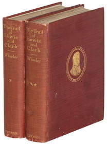
SoldJournals of The Expedition of Lewis and ClarkThis lot includes Volume 1 and 2 of Lewis and Clark's Expedition diaries includes a multitude of illustrations, drawings and maps. The introduction was written by John Bakeless, who has written over aSee Sold Price
SoldThe Expeditions of John Charles FremontBooks and Maps: "The Expeditions of John Charles Fremont". Comprises three volumes in four hardcover books, plus the map portfolio in slipcase. Volume 1, (published 1971) Travels from 1838-1844, VolumSee Sold Price
SoldBook, Clarke's Travels in Various CountriesTen volumes, 1-11, missing volume 6. Fourth edition, 1817. Quarter bound with many pull-out maps, not collated. Dimensions: Each is 9" x 5 1/2".See Sold Price
SoldEXPLORATION OF THE VALLEY OF THE AMAZON. 3 Vols.[Latin America] Wm. Lewis Herndon and Lardner Gibbon. EXPLORATION OF THE VALLEY OF THE AMAZON, Made under the Direction of the Navy Department. 3 Vols total: 2 Text Volumes & 1 Map volume to accompanySee Sold Price
1816 MAP SOUTHERN PART OF RUSSIA or MUSCOVY in EUROPE copper engraving ANTIQUEJasper524.5(9.9k)See Sold PriceFeb 27, 2024
1816 MAP NORTHERN PART OF RUSSIA or MUSCOVY in EUROPE copper engraving ANTIQUEJasper524.5(9.9k)See Sold PriceFeb 27, 2024
1749-59 21 volumes NETHERLANDS HISTORY ILLUSTRATED antique VELLUM BOUNDJasper524.5(9.9k)See Sold PriceFeb 27, 2024
1709 GREEK BIBLE ILLUSTRATED w/ MAPS antique VELLUM BOUND Septuagint editionJasper524.5(9.9k)See Sold PriceFeb 27, 2024
1825 Vandermaelen Map of the Curacao, Aruba -- Amer. Sep. Curacao No. 74.Jasper524.5(9.9k)See Sold PriceFeb 27, 2024
Carte de la Barbarie… l'empire de Maroc… North Africa Morocco. LAPIE 1829 mapJasper524.5(9.9k)See Sold PriceFeb 28, 2024
MAGHREB. North Africa Morocco Algeria & Tunisia. JOHNSTON 1913 old antique mapJasper524.5(9.9k)See Sold PriceFeb 28, 2024
Carte d'Afrique. Africa Soudan Zanzibar. LAPIE 1831 old antique map plan chartJasper524.5(9.9k)See Sold PriceFeb 28, 2024
Framed Vintage Style Visscher Commander Repro MapRapid Estate Liquidators and Auction Gallery4.5(1.1k)See Sold PriceMar 01, 2024
Standard Home Library Hammond Family World Atlas Volume 2Rapid Estate Liquidators and Auction Gallery4.5(1.1k)See Sold PriceMar 02, 2024