MATTHEWS c1856 Map Of Upper Canada Ontario Indian Land Agency Divisions Scarce!Luis Porretta Fine Arts4.3(10)See Sold PriceMar 02, 2024
DEVINE c1856 Dr Salters Map Of Lake Huron Ontario Indian Lands etc. No. 7 ScarceLuis Porretta Fine Arts4.3(10)See Sold PriceMar 02, 2024
DUNLEVIE c1856 Map Counties Of Gaspe & Bonaventure Quebec Canada SCARCE! #1Luis Porretta Fine Arts4.3(10)See Sold PriceMar 02, 2024
DUNLEVIE c1856 Map Counties Of Gaspe & Bonaventure Quebec Canada SCARCE! #2Luis Porretta Fine Arts4.3(10)See Sold PriceMar 02, 2024
Map UNITED COUNTIES LEEDS & GRENVILLE by Walling 1861 Rare Canada Map 5ft x 5ftLuis Porretta Fine Arts4.3(10)See Sold PriceMar 02, 2024
Ambroise TARDIEU c1822 Map Venice Napoleon Italian Campaign 17" x 11"Luis Porretta Fine Arts4.3(10)See Sold PriceMar 02, 2024
SoldMap of Eastern States With Part of Canada, 1814Title/Content of Map: Eastern States With Part of Canada Date Printed: 1814 ca. Cartographer: ANONYMOUS Size (inches): 22.75x20.25 Simple map, with some topography. Modern color. Please note that thisSee Sold Price
SoldMap The State Of Ohio W/ Part Of Canada 1814 Cary1814 Engraved Map entitled "The State of Ohio with Part of Canada, & c., framed and matted, 22" x 26" overall by CarySee Sold Price
SoldCarey, Mathew (1790-1839). The State of Ohio with partCarey, Mathew (1790-1839). The State of Ohio with part of Upper Canada. Philadelphia, 1814, Hand colored, copper plate engraving published in 'A General Atlas...'. Full margins.See Sold Price
SoldCarey, Mathew (1790-1839). The State of Ohio with partCarey, Mathew (1790-1839). The State of Ohio with part of Upper Canada. Philadelphia, 1814, Hand colored, copper plate engraving published in 'A General Atlas...'. H: 16 W: 15 in. From the VixseboxseSee Sold Price
EASTERN UNITED STATES. Railroads. Population table.TITLE/CONTENT OF MAP: 'United States of North America and part of Canada (Eastern Sheet)' DATE PRINTED: 1883 IMAGE SIZE: Approx 40.0 x 35.0cm, 15.75 x 13.75 inches (Large); Please note that this is aSee Sold Price
Stockdale: Antique Map of Eastern United States, 1798Title: 1798 Stockdale Map of Eastern United States -- Part of the United States of North America Cartographer: J. Stockdale Year / Place: 1798 London Map Dimensions: 18.4 x 16.2 in. Condition: Very GoSee Sold Price
Stockdale: Antique Map of Eastern United States, 1798Map: 1798 Stockdale Map of Eastern United States -- Part of the United States of North America Date Printed: 1798 London Cartographer: J. Stockdale Size: 18.4 x 16.2 in. Condition: Very Good. Issued fSee Sold Price
Stockdale: Map of Eastern United States, 1798Map: 1798 Stockdale Map of Eastern United States -- Part of the United States of North America Cartographer: J. Stockdale Year / Place: 1798 London Map Dimensions: 18.4 x 16.2 in. Condition: Very GoodSee Sold Price
Sold1798 Stockdale Map of Eastern United StatesTitle/Content of Map: 1798 Stockdale Map of Eastern United States -- Part of the United States of North America Date Printed: 1798 London Cartographer: J. Stockdale Size: 18.4 x 16.2 in. This antiqueSee Sold Price
Sold(1797) Map of the Eastern United States + CanadaHistoric Maps Federal Period Hand-Colored Map of the United States Early (1797) Hand-Colored Map of the Eastern United States and Canada. "Carte Generale des Etats Unis de l'Amerique Septentrionale, RSee Sold Price
SoldBartholomew's topographical map of the United StatesBatholomew, John George. Bartholomew's topographical map of the United States and part of Canada. 1873Dimensions: 30 1/4" X 41" Inv.6See Sold Price
Bartholomew's topographical map of the United StatesBatholomew, John George. Bartholomew's topographical map of the United States and part of Canada. 1873Dimensions: 30 1/4" X 41" Inv.6See Sold Price
SoldBartholomew's Orographical Map of the Unite State andBartholomew's Orographical Map of the Unite State and Part of Canada, 1920. Map is made of canvas and in very good condition. Folded measures 8 x 4.25", Unfolded 42.5 x 31.75"See Sold Price
SoldWESTERN USA States & territories Central PacificTITLE/CONTENT OF MAP: 'United States of North America and part of Canada (Western Sheet)' DATE PRINTED: 1883 IMAGE SIZE: Approx 36.5 x 42.0cm, 14.25 x 16.5 inches (Large); Please note that this is a fSee Sold Price
SoldAndrews' Series of Wall Maps. Map of the United StatesTitle/Content of Map: Andrews' Series of Wall Maps. Map of the United States Mexico and Parts Of Canada and the West Indies Date: c1889 Cartographer: G.W. Bacon Publisher: A.H. Andrews & Co. Size: 45HSee Sold Price
MAP - Eastern US & Canada. OttensColonial Eastern United States & Canada. Reiner and Joshua Ottens, Carte des Possessions Angloises & Francoises du Continent de l'Amerique Septentrionale / Kaart van de Engelsche en Fransche BezittingSee Sold Price
MAP - Eastern US & Canada. D'AnvilleColonial Eastern United States & Canada. Jean Baptiste Bourguignon d'Anville, [On 4 Sheets] Canada Louisiane et Terres Angloises, 1755 (dated). Black & White. This large-scale map covers the region frSee Sold Price
SoldRasmusio and Gastaldi Map of Eastern Seaboard 160Giovanni Battista Rasmusio (1485-1557) and Giacomo Gastaldi (1500-1566), "La Nuova Francia," Venice, 1606. Woodcut map depicting the eastern seaboard of the United States and Canada from New York BaySee Sold Price
SoldUnited States and Republic of Texas mapdated 1844; "Map of "The United States, Canada and part of Mexico," (sic) from "Olney's School Atlas," hand colored map, 10 1/2 x 17 1/2 in.; Purchased from Charles Edwin Puckett.See Sold Price
Sold238. 19th Century Map of the United States, Canada, Tex238. 19th Century Map of the United States, Canada, Texas & Part of Mexico: To Illustrate Olney's School Geography. Creation date 1844. Drawn and engraved by Sherman and Smith, N.Y. This map shows theSee Sold Price
SoldColton's Railroad and Township of New York, MapColton's Railroad and Township of New York Map, with part adjoining States & Canada, on the bottom margin, "Drawn by George W. Colton," "J.M. Atwood Sculp. Entered by Act of Congress 1852…" Blue staSee Sold Price
Sold1893 HOUSE OF REPRESENTATIVES FOLDING ROOM MAP"Map of the United States","Territories with adjacent parts of Canada and Mexico also part of the West India Islands", General Land Office under the direction of the Hon. Silas W. Lamoreux, with origiSee Sold Price
United States, Canada and part of Mexico. 1871.Map of the United States, Canada and part of Mexico. North America. 1871.Print from steel engraving titled „Carte physique des Etats-Unis Canada et partie du Mexique“.Author/compiler - MM. DriouxSee Sold Price
1892 Map of the Eastern States of the USTitle: 1892 Map of the Eastern States of the US Author: Bacon Medium: Ink on Paper Dimensions: 13.5"X21" Description: Map of the Eastern States of the US dated 1892. Part of Bacon's Commercial and LibSee Sold Price
LARGE LATE 17TH C. DUTCH CHART OF CANADA, GREAT LAKES, NEW FRANCE, LABRADOR, HUDSON BAY, BY PIERREThomaston Place Auction Galleries4.4(386)See Sold PriceFeb 24, 2024
1887 Appletons' General Guide to the United State and Canada Part IIRail & Road Auctions4.6(165)See Sold PriceMar 08, 2024
Carey, pub. 1796 - Map of the Tennassee State formerly part of North Carolina (Tennessee)Trillium Antique Prints & Rare Books4.5(30)See Sold PriceFeb 24, 2024
Wilson - Wood Thrush, Red-breasted Thrush or Robin, & Nuthatches. 2Trillium Antique Prints & Rare Books4.5(30)See Sold PriceFeb 24, 2024
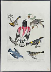
Wilson - Grosbeak, Warbler, Siskin, & Flycatcher. 17Trillium Antique Prints & Rare Books4.5(30)See Sold PriceFeb 24, 2024
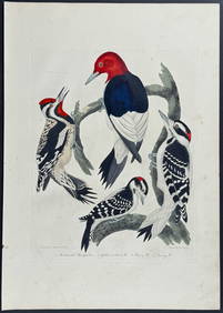
Wilson - Woodpeckers - Red-headed, Yellow-bellied, Hairy, & Downy. 9Trillium Antique Prints & Rare Books4.5(30)See Sold PriceFeb 24, 2024
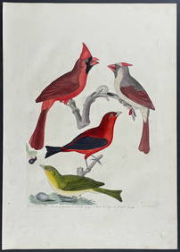
Wilson - Cardinal Grosbeak & Red Tanager. 11Trillium Antique Prints & Rare Books4.5(30)See Sold PriceFeb 24, 2024
Wilson - Mottled Owl, Lark, Creeper, & Warbler. 19Trillium Antique Prints & Rare Books4.5(30)See Sold PriceFeb 24, 2024
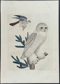
Wilson - Snow Owl (Snowy Owl) & Sparrow Hawk. 32Trillium Antique Prints & Rare Books4.5(30)See Sold PriceFeb 24, 2024
Wilson - Ivory-billed Woodpecker, Red-headed & Pileated Woodpeckers. 29Trillium Antique Prints & Rare Books4.5(30)See Sold PriceFeb 24, 2024
Wilson - Carolina Parrot & Flycatchers. 26Trillium Antique Prints & Rare Books4.5(30)See Sold PriceFeb 24, 2024
1738 RUSSIA SIBERIA & GREAT TARTARY Description illustrated ANTIQUE in ENGLISHJasper524.5(9.8k)See Sold PriceFeb 27, 2024
Cooke, George 1801 Antique Map. United States of AmericaAlbion Auctions4.6(336)See Sold PriceMar 01, 2024