SoldMap, Victor Levasseur, Dept de Loir et CherVictor Levasseur (French, 1800-1870), "Dept. de Loir et Cher," hand-colored map, overall (with frame): 23"h x 29"w. Provenance: Property from the Sterling Vineyard Winery Art Collection, Calistoga, CASee Sold Price
Sold(2) FRAMED HAND COLORED MAPS AFTER V. LEVASSEUR(lot of 2) Framed hand colored maps, each after Victor Levasseur (French 1800-1870), comprising: (1) "Dept. de Loir et Cher"; (1) "Dept. de la Cote D'Or"; sight: 12"h, 17"w, overall: 19.5"h, 24.5"w, 7See Sold Price
Victor Levasseur Cartographer Paris, France Two (2Victor Levasseur Cartographer Paris, France Two (2) 19th Century Framed Maps "Dept d'Eure et Loir" and "Dept de la The Vienne" Circa 1850. Atlas National Illustre. Very Good Condition. Measures 12 IncSee Sold Price
French Cylindrical Form Tole Lamp, Early 20th CenturyThe lamp with a laminated polychrome map of the loir region with historic figures in registers. Raised on a sockled form base. Entitled “Dept De Loir Et Cher”. Dimensions: Height 26”, Diameter 6See Sold Price
Original Etching - Levasseur - Dept de Tarn et GaronneVictor Levasseur (1800–1870) Dept de Tarn et Garonne Engraving 13 x 18 in 33 x 46 cm 1852 France. Original map on steel by Victor Levasseur, engraved by Laguillermie and Rainaud. Hand-coloured. VictSee Sold Price
SoldLevasseur, Victor C1850 Map of Paris, France"Dept de Seine et Oise" Showing Paris and area. Steel Engraved Decorative Map Published C1850, Paris for "Atlas National Illustre" by Victor Levasseur. Paper Size: 20.5 x 15 inch (52 x 38cm) Good CondSee Sold Price
SoldLevasseur, Victor 1869 Group of 3 Maps of France"Loir et Cher" "Bas Rhin" and "Loire" Steel Engraved Maps Published 1869, Paris for "Atlas National Illustre" by Victor Levasseur. Paper Size: 20.5 x 14.5 inch (52 x 37cm) Good ConditionSee Sold Price
SoldLevasseur, Victor 1859 Lot of 6 Large French MapsIncl Maine et Loire, Doubs, Loir et Cher, Gard, L'Ardeche, L'Aisne. Steel Engraved Maps Published 1859, Paris for "Atlas National Illustre" by Victor Levasseur. Outline hand colour. Paper Size: 20 x 1See Sold Price
France: Dept. Du Loiret by Levasseur, 1845Original engraving of the Loiret department of France from "Atlas National Illustre" by Victor Levasseur and engraving by A. Combette, Paris, 1845. Victor Levasseur (1800-1870) was a French surveyor aSee Sold Price
SoldLevasseur, Victor 1859 Pair of Maps of Paris, France"Seine et Oise" and "Dept de la Seine" Steel Engraved Map Published 1859, Paris for "Atlas National Illustre" by Victor Levasseur. Paper Size: 20.5 x 14.5 inch (52 x 37cm) Good ConditionSee Sold Price
SoldJAN JANSSON & VICOR LEVASSEUR MAPS - TWO WORKS.JAN JANSSON & VICOR LEVASSEUR MAPS - TWO WORKS. Levasseur: Dept. de Maine et Loire, color engraving, circa 1859 (12.50' x 17.4" sight). Jansson: Principatus Anhaldinus et Magdeburgensis ArchiepiscopatSee Sold Price
Sold1860 Map of Paris11.5" x 17", Victor Levasseur, Dept de la Seine, Pub in Paris 1860See Sold Price
France: Dept. Du Loiret by Levasseur, 1845Original engraving of the Loiret department of France from "Atlas National Illustre" by Victor Levasseur and engraving by A. Combette, Paris, 1845. Victor Levasseur (1800-1870) was a French surveyor aSee Sold Price
France: Dept. Du Loiret by Levasseur, 1845Original engraving of the Loiret department of France from "Atlas National Illustre" by Victor Levasseur and engraving by A. Combette, Paris, 1845. Victor Levasseur (1800-1870) was a French surveyor aSee Sold Price
France: Dept. Du Loiret by Levasseur, 1845Original engraving of the Loiret department of France from "Atlas National Illustre" by Victor Levasseur and engraving by A. Combette, Paris, 1845. Victor Levasseur (1800-1870) was a French surveyor aSee Sold Price
Sold19TH CENTURY HAND COLORED DEPT. DE LA CÔTE D'OR MAP FRANCE1857 map of French department of cote d'or France. Part of France's burgundy or bourgogne wine region. decorative engravings around map. published by Victor Levasseur. Atlas National IllustreSee Sold Price
SoldLevasseur, Victor 1859 Map of The Dordogne & Title Page"Dept. de la Dordogne" and Title Page. Steel Engraved Maps Published 1859, Paris for "Atlas National Illustre" by Victor Levasseur. Paper Size: 20.5 x 14.5 inch (52 x 37cm) Good ConditionSee Sold Price
SoldVictor Jules Levasseur (1800-1870) Map of ParisA hand colored map titled "Dept. de la Seine", from "Atlas National Illustree", engraved by Laguillermie and Rainaud; unknown edition. Dimensions: Sight 12 1/4" x 18", the frame 21 3/4" x 27 1/4".See Sold Price
Levasseur (Victor) Dépt du Haut RhinLevasseur (Victor) Dépt du Haut Rhin; ...de la Loire; ...de la Lozère; ...du Doubs, 4 engraved maps of French regions, with original outline hand-colouring, ornate decorated borders depictingSee Sold Price
SoldMap 19th Century "Dept De Vaucluse",by Victor Levasseur, c.1852, handcoloured etching, This is a fascinating 1852 map of the French department of Vaucluse, France. Vaucluse is the center of wine production in the southern Rhone. Some ofSee Sold Price
SoldLevasseur, Victor 1859 Lot of 6 Large French MapsIncl L'Isere, Garonne, Loiret, Lot, L'Aude, L'Aube. Steel Engraved Maps Published 1859, Paris for "Atlas National Illustre" by Victor Levasseur. Outline hand colour. Paper Size: 20 x 14.5 inch (51 x 3See Sold Price
SoldFRANCE. Cher, Sarthe, Loir-et-Cher... Ensemble 56 carteFRANCE. Cher, Sarthe, Loir-et-Cher... Ensemble 56 cartes postales. Rues animées, marchés...See Sold Price
SoldFrench Map AssortmentFrench Map Assortment (4) maps from the 'Atlas National Illustre' published by V. Levasseur, Paris in 1851 including 'Dept. Du Finistere', 'Dept. De Seine Et Marne', 'Dept. Du Jura' and 'Dept. Des DeuSee Sold Price
SoldLevasseur, Victor 1859 Lot of 6 Large French MapsIncl L'Eure, D'Eure et Loir, Finistere, Creuse, Correze, and Cotes du Nord. Steel Engraved Maps Published 1859, Paris for "Atlas National Illustre" by Victor Levasseur. Outline hand colour. Paper SizeSee Sold Price
FRANK HARDING c1885 Original Signed Etching Westminster Bridge London FramedLuis Porretta Fine Arts4.3(10)See Sold PriceMar 02, 2024
FRANK HARDING c1885 Original Signed Etching Tower Bridge London FramedLuis Porretta Fine Arts4.3(10)See Sold PriceMar 02, 2024
FRANK HARDING c1885 Original Signed Etching Westminster London Framed Beautiful!Luis Porretta Fine Arts4.3(10)See Sold PriceMar 02, 2024
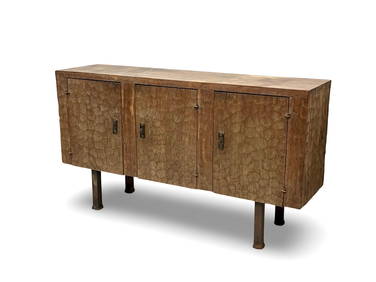
LES ARTISANS DE MAROLLES & DE LOIR ET CHER sous la direction artistique de Jean TOURET (1916-2004):Valoir Pousse-Cornet4.3(4)See Sold PriceFeb 24, 2024
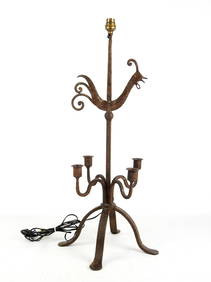
LES ARTISANS DE MAROLLES ET DU LOIR ET CHER (dans le goût de) : Lampadaire tripode en fer forgé àValoir Pousse-Cornet4.3(4)See Sold PriceFeb 24, 2024
LES ARTISANS DE MAROLLES ET DU LOIR ET CHER (dans le goût de) : Candélabre en fer forgé à cinqValoir Pousse-Cornet4.3(4)See Sold PriceFeb 24, 2024
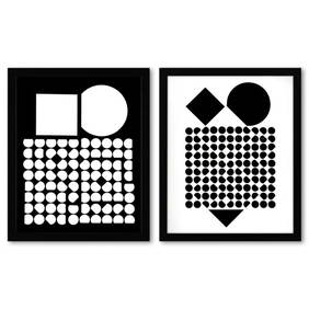
Victor Vasarely (1908-1997), "Cassiopee et Bellatrix de la serie Corpusculaires (Diptych)" FramedRobinhood Auctions4.7(783)See Sold PriceFeb 25, 2024
Railways & Transport.- [Prospectus] The Dorking, Brighton, and Arundel Atmospheric Railway, byForum Auctions4.3(52)See Sold PriceFeb 29, 2024
Jules Verne, Mirifiques Aventures de Maitre, Aux HarponsLion and Unicorn4.7(1.8k)See Sold PriceMar 03, 2024
Jules Verne, Le Testament d'un Excentrique, Aux HarponsLion and Unicorn4.7(1.8k)See Sold PriceMar 03, 2024
Jules Verne, Mirifiques Aventures de Maitre, Aux HarponsLion and Unicorn4.7(1.8k)See Sold PriceMar 03, 2024
Jules Verne, P'tit Bonhomme, Aux Harpons, Red CoverLion and Unicorn4.7(1.8k)See Sold PriceMar 03, 2024
1764 Bellin Chart of Three South Haitian Bays -- Carte des Bayes du Mesle des Flamands et deJasper524.5(9.8k)See Sold PriceFeb 27, 2024
1764 Bellin Map of Port Antonio, Jamaica -- Plan des Havres de Port Antonio et de Saint FrancoisJasper524.5(9.8k)See Sold PriceFeb 27, 2024
La Barbarie de la Nigritie et de la Guinée'. West Africa. DE L’ISLE 1745 mapJasper524.5(9.8k)See Sold PriceFeb 28, 2024
États du Roi de Maroc… d’Alger, Tunis & Tripoli. North Africa. BONNE 1790 mapJasper524.5(9.8k)See Sold PriceFeb 28, 2024
Bakka, Dakha or Bangua plant. Bukhu plant or Spiraea. Kolben 1748 old printJasper524.5(9.8k)See Sold PriceFeb 28, 2024
SOUTHERN AFRICA Monomotapa (Mutapa Kingdom) Cafrerie (Kaffraria) MALLET 1683 mapJasper524.5(9.8k)See Sold PriceFeb 28, 2024
RAVEL MAURICE: (1875-1937)International Autograph Auctions Europe S.L.4.5(52)See Sold PriceMar 13, 2024
1774: AN ANTIQUE ILLUSTRATED TWO-VOLUME HISTORY OF PERUVIAN DISCOVERY AND CONQUEST WITH MAPNY Elizabeth 4.3(84)See Sold PriceMar 03, 2024
Jules Verne, De La Terre a La Lune, Au Steamer Red MacaronLion and Unicorn4.7(1.8k)See Sold PriceMar 10, 2024
Jules Verne, L'Archipel en Feu, Au Steamer Red MacaronLion and Unicorn4.7(1.8k)See Sold PriceMar 10, 2024
Jules Verne, L'Etoile du Sud, Au Steamer Red MacaronLion and Unicorn4.7(1.8k)See Sold PriceMar 10, 2024


![Railways & Transport.- [Prospectus] The Dorking, Brighton, and Arundel Atmospheric Railway, by (1 of 1)](https://p1.liveauctioneers.com/5458/319736/171654703_1_x.jpg?height=282&quality=70&version=1708010439)