RARE 1930s AUTOGRAPH BOOK FEATURING RUTH & GEHRIGJohn McInnis Auctioneers,LLC4.5(505)See Sold PriceFeb 25, 2024
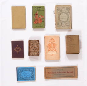
Group of Ten Books: Art of the Embroiderer, Charles Germain de Saint Aubin; Hand Weaving PatternsNazmiyal Auctions4.4(34)See Sold PriceFeb 26, 2024
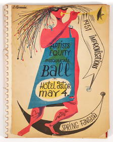
Improvisations II 55 original lithographs Artists Equity Assoc 1951Concept Art Gallery4.7(510)See Sold PriceMar 06, 2024
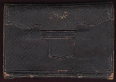
1868 Handwritten diary of Ohio canal boat operator & farmerJasper524.5(9.9k)See Sold PriceFeb 27, 2024
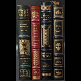
Lot Of 4 Mint Limited Edition Books From The Franklin Library.Rbfinearts4.5(578)See Sold PriceFeb 24, 2024
A Group of Eight Books: Line and Form, Walter Crane (1900); Samplers and Stitches; Designs forNazmiyal Auctions4.4(34)See Sold PriceFeb 26, 2024
First Copy of Gautier's Le Roman de la Momie - 13 Original Watercolors by George Barbier (2 VolumesTrillium Antique Prints & Rare Books4.5(32)See Sold PriceFeb 24, 2024
Group of Nine Books: Handbook of Embroidery; The Book of Stitches, Ellen T. Masters; The Lady'sNazmiyal Auctions4.4(34)See Sold PriceFeb 26, 2024
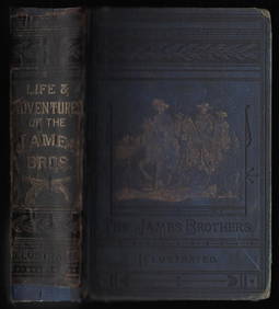
Outlaws of the Border, rare 1882 Jesse James, Younger brothersJasper524.5(9.9k)See Sold PriceFeb 27, 2024
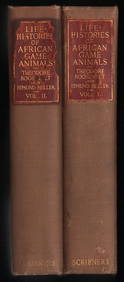
Scarce 1st ed. “Life Histories of African Game Animals?? – T. Roosevelt, E. HellerJasper524.5(9.9k)See Sold PriceFeb 27, 2024
Large lot of exhibition catalogs on CoBrA artistsConcept Art Gallery4.7(510)See Sold PriceMar 06, 2024
Compleat Plattmaker Essays on Chart Map & Globe MakingThe Compleat Plattmaker. Essays on Chart, Map, and Globe Making in England in the Seventeenth and Eighteenth Centuries. Thrower, Norman J.W. (ed). William Andrews Clark Memorial Library. University ofSee Sold Price
Essays on Chart Map Globe Making 17th-18th C EnglandThe Compleat Plattmaker. Essays on Chart, Map, and Globe Making in England in the Seventeenth and Eighteenth Centuries. Thrower, Norman J.W. (ed). William Andrews Clark Memorial Library. University ofSee Sold Price
The Compleat Plattmaker. Essays on Map MakingTitle: The Compleat Plattmaker. Essays on Chart, Map, and Globe Making in England in the Seventeenth and Eighteenth Centuries. Los Angeles. Berkeley. William Andrews Clark Memorial Library. UniversitySee Sold Price
SoldSmall group of works on mapsTitle: Small group of works on maps Author: ** Description: Includes: * Thrower, Norman J.W. The Compleat Plattmaker: Essays on Chart, Map, and Globe Making in England. Cloth. University of CaliforniaSee Sold Price
SoldMaps and Map Making (9) BooksGroup of nine books of maps and map making. Includes: 1) Two 1978 editions. The Compleat Plattmaker by Norman Thrower. 2) Proceedings of the Vinland Map Conference by Washburn. 1971. 3) American MapsSee Sold Price
SoldChart of the World with Anson's route around itHeading: Author: Bellin, Jacques Nicolas Title: Essay d'une Carte Reduite Contenant les Parties Connues du Globe Terrestre... Avec la route qu'a tenu l'Amiral Anson Place Published: Paris Publisher:See Sold Price
SoldVintage 1953 Anatomical Model of Human EarVintage 1953 Articulated Anatomical Medical Teaching Model of Human Ear, Biocraft Denoyer-Geppert Co, Made in Chicago. Marked on base, Denoyer-Geppert Co. Models - Charts - Maps - Globes, Made ChicagoSee Sold Price
SoldMaps, Charts, Globes: Five Centuries of ExplorationTitle: Maps, Charts, Globes: Five Centuries of Exploration. A New Edition of E.L. Stevenson's Portolan Charts and Catalogue of the 1992 Exhibition New York. The Hispanic Society of America. 1992 AuthoSee Sold Price
Surrey.Title: Surrey. Cartographer: Ordnance Survey Publisher: Letts, Son & Co. Height: 25.25 Width: 37.25 Imprint label on margin reading, "Letts, Son & Co., 8 Royal Exchange, E.C., map, chart and globe selSee Sold Price
Sold(Maps and Charts, Globe, Celestial), Wilson's New(Maps and Charts, Globe, Celestial), Wilson's New American Thirteen Inch Terrestrial Globe, Cyrus Lancaster, Albany, 1845, with brass meridien, horizon bar printed with the zodiac, the cherry stand wiSee Sold Price
Sold1775 THOMAS JEFFERYS WEST INDIES MAPJEFFERYS, Thomas, (1719-1771): An Index Map to the Following Sixteen Sheets; being a Compleat Chart of the West Indies map. London: Robert Sayer, 1775. Copper engraving, 14 1/2'' x 25'' ins., Hand colSee Sold Price
Rare 1st ed. 1846 Indo-German map of the worldWorld map in color showing the distribution of Indo-Germanic people throughout the globe. Map accompanied by charts. From the first comprehensive physical atlas of the world. This map comes from the rSee Sold Price
SoldRoderick Slater Map Collage Mixed Media PaintingUnited States,1937-2019 Rectilinear collage of maps, telescopes, globes, and charts with painted acrylic clouds. Slater was known for his collages and three dimensional creations with works in the colSee Sold Price
SoldTHOMAS JEFFERYS, CARIBBEAN, CENTRAL AMERICAN MAPThomas Jefferys (British, died 1771). "An Index Map to the Following Sixteen Sheets Being a Compleat Chart of the West Indies" -1775, engraving with hand coloring for Robert Sayer, map and print selleSee Sold Price
Sold9V HISTORY OF MAP MAKING AND CARTOGRAPHY Books-On-Books9V HISTORY OF MAP MAKING AND CARTOGRAPHY Books-On-Books Folio Oversized Illustrated Fold-Out Greek Roman Maps Globe of Martin Bylica of Olkusz Celestial Historical Survey of Study and Collecting R A SSee Sold Price
SoldIndex map to Jefferys' West Indies 1775Title: An Index Map to the Following Sixteen Sheets, Being a Compleat Chart of the West Indies Author: Jefferys, Thomas Description: Copper-engraved map. 38x63 cm. (15x25").The index sheet to JefferysSee Sold Price
Early Map of the West IndiesHigh Quality Reprint of Map by Sayer and Bennett London 1775. Hand colored, printed for Barre Publishers in 1969. An index map to the following sixteen sheets, being a compleat chart of the West IndieSee Sold Price
Index map to Jefferys' West Indies 1775Title: An Index Map to the Following Sixteen Sheets, Being a Compleat Chart of the West Indies Author: Jefferys, Thomas Description: Copper-engraved map. 38x63 cm. (15x25").The index sheet to JefferysSee Sold Price
Eleven volumes on mapsTitle: Eleven volumes on maps Author: ** Description: Includes: * Tyacke, Sarah. English Map-Making 1500-1650. Cloth, dj. The British Library, [1983]. * Sellers, John R. Maps and Charts of North AmeriSee Sold Price
Sold1748 Bellin World Map -- Essay d'une Carte Reduite,Reserve Reduced! Title/Content of Map: 1748 Bellin World Map -- Essay d'une Carte Reduite, Contenant les Parties Connuees du Globe Terrestre Date: 1748, Paris Cartographer: J Bellin Size: 19.6 X 27.4See Sold Price
1748 Bellin World Map -- Essay d'une Carte Reduite,Reserve Reduced! Title/Content of Map: 1748 Bellin World Map -- Essay d'une Carte Reduite, Contenant les Parties Connuees du Globe Terrestre Date: 1748, Paris Cartographer: J Bellin Size: 19.6 X 27.4See Sold Price
Essay d'une Carte Réduite Parties Connues du GlobeTITLE/CONTENT OF MAP: 'Essay d'une Carte Réduite contenant les Parties Connues du Globe Terrestre; Dedié à M le Comte de Maurepas [A Reduced Map of the Known Parts of the World]' This map is foldinSee Sold Price
Essay d'une Carte Réduite Parties Connues du GlobeTITLE/CONTENT OF MAP: 'Essay d'une Carte Réduite contenant les Parties Connues du Globe Terrestre; Dedié à M le Comte de Maurepas [A Reduced Map of the Known Parts of the World]' DATE PRINTED: 1748See Sold Price
Antique Hand Colored Engraving - Planetary Theory - Nicolas Sanson - Celestial Chart World MapThis detailed map is from Nicolas Sanson, Guillame Sanson, and Nicolas Bion's "Description de tout l’Univers... [suivi de] L'usage des globes celestes et terrestres et des spheres...". The workSee Sold Price
West Africa by Arrowsmith & Lewis 1812 old antique vintage map plan chartJasper524.5(9.9k)See Sold PriceFeb 28, 2024
AFRICA. Antiqua; Rome Carthage, start Punic War 1908 old antique map chartJasper524.5(9.9k)See Sold PriceFeb 28, 2024
AFRICA. Pre 'Scramble for Africa'. BARTHOLOMEW 1876 old antique map plan chartJasper524.5(9.9k)See Sold PriceFeb 28, 2024
Western Sahara. Africa 1885 old antique vintage map plan chartJasper524.5(9.9k)See Sold PriceFeb 28, 2024
AFRICA. Africa. Britannica 9th edition 1898 old antique vintage map plan chartJasper524.5(9.9k)See Sold PriceFeb 28, 2024
East coast of Africa from the Cape… South Africa Mozambique. CHILD 1745 mapJasper524.5(9.9k)See Sold PriceFeb 28, 2024
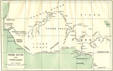
AFRICA. Niger River and Tributaries 1936 old vintage map plan chartJasper524.5(9.9k)See Sold PriceFeb 28, 2024
Western coast of Africa… to the River Sanaga. Southern Mauritania LABAT 1745 mapJasper524.5(9.9k)See Sold PriceFeb 28, 2024
AFRICA. French North Africa and Morocco 1907 old antique map plan chartJasper524.5(9.9k)See Sold PriceFeb 28, 2024
Afrique Ancienne. Ancient North Africa. MALTE-BRUN c1871 old antique map chartJasper524.5(9.9k)See Sold PriceFeb 28, 2024
NAMIBIA. South West Africa protectorate. HARMSWORTH 1920 old antique map chartJasper524.5(9.9k)See Sold PriceFeb 28, 2024
Showers of Red Dust. Africa. Sahara 1886 old antique vintage map plan chartJasper524.5(9.9k)See Sold PriceFeb 28, 2024
Africa by Arrowsmith & Lewis 1812 old antique vintage map plan chartJasper524.5(9.9k)See Sold PriceFeb 28, 2024