MAP - PIETER SCHENK / VALK / JANSSEN Hand Colored superb Map Central Italy c1702Luis Porretta Fine Arts4.3(10)See Sold PriceMar 02, 2024
CHARLES ROLLIN c1828 Ceasar Hand Colored Africa Military MapLuis Porretta Fine Arts4.3(10)See Sold PriceMar 02, 2024
MAP - Dufour, A. H. ( Malte / Brun ) :MAP - ESPAGNE PARTIE SUD DIVISEE EN PROVINCES ANCIENNES ( MAPLuis Porretta Fine Arts4.3(10)See Sold PriceMar 02, 2024
RIGOBERT BONNE c1787 Original Colored Map Germany & Region 15" x 12"Luis Porretta Fine Arts4.3(10)See Sold PriceMar 02, 2024
AMBROISE TARDIEU c1822 Napoleonic War Map GermanyLuis Porretta Fine Arts4.3(10)See Sold PriceMar 02, 2024
MAP - AMBROISE TARDIEU c1822 Napoleonic Miltary Map GermanyLuis Porretta Fine Arts4.3(10)See Sold PriceMar 02, 2024
1822 Rare Map by Ambroise Tardieu Napoleon Caldiero Battle of Vento 17" x 11Luis Porretta Fine Arts4.3(10)See Sold PriceMar 02, 2024
PIETER SCHENK / VALK / JANSSEN Hand Colored Map of Rhodes Greece ca1702 vgcLuis Porretta Fine Arts4.3(10)See Sold PriceMar 02, 2024
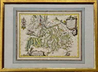
Map: Carte du Canton de Bale, Jacques Clermont, Paris, 1788Kensington Estate Auction4.6(216)See Sold PriceFeb 26, 2024
Bonne: Antique Map of French Guiana, 1780TITLE/CONTENT OF MAP: 'La Guyane Françoise, avec partie de la Guyane Hollandoise' A map of French Guiana, with part of Dutch Guyana (Suriname) DATE PRINTED: 1780 IMAGE SIZE: Approx 34.0 x 23.5cm, 13.See Sold Price
Bonne: Antique Map of Isles of France, 1780TITLE/CONTENT OF MAP: 'Cartes Particulieres des Isles de France, de Bourbon et de Rodgrigue' A map of the Indian Ocean archipelago of the Mascarene or Mascarenhas islands: Île Bourbon (now Réunion),See Sold Price
Bonne: Antique Map of Guadeloupe, Marie Galante 1780TITLE/CONTENT OF MAP: 'Les Isles de la Guadeloupe, de Marie Galante, de la Désirade: Colonie Françoise dans les Antilles' A map of the French Caribbean islands of Guadeloupe, Marie Galante and the �See Sold Price
EARLY MAPS OF FRENCH GUIANA (3)Fine lot of three eighteenth-century maps depicting the colony of French Guiana. The first, 9 3/4' x 14 3/4', was created by cartographer M. Bonne circa 1780, and shows the small colony shortly afterSee Sold Price
SoldFrench Map of Southern United States by M. Bonne, 1Early French Map of Southern United States "Carte de la Partie Sud des Etats Unis de L'Amerique Septentrionale" by M. Bonne, Paris, c. 1780. A rare colored map of the southeastern US printed during thSee Sold Price
Bonne: Antique Map of French Guyana & Surinam, 1727Map: French Guyana & Surinam Date Printed: 1727-95 Cartographer: Rigobert Bonne Material/Medium: Paper Size: 9 3/4" x 15" Copperplate engraving. Printed in Paris. From the 'Atals Portatit'. Rigobert BSee Sold Price
Bonne: Antique Map of Scandinavia, 1780Title/Content of Map: 'Le Nord de l'Europe contenant le Danemark, la Norwege, la Suede et la Laponie, avec le Majeure partie de la Russie Européenne' A map of Scandinavia, the Baltic Sea and the nortSee Sold Price
SoldBonne: Antique Map of Italy, 1780TITLE/CONTENT OF MAP: 'L'Italie' A map of Italy DATE PRINTED: 1780 IMAGE SIZE: Approx 34.0 x 23.0cm, 13.25 x 9 inches (Large); Please note that this is a folding map. TYPE: Antique copperplate engraveSee Sold Price
SoldBonne: Antique Map of Jamaica, 1780TITLE/CONTENT OF MAP: 'Carte de l'Isle de la Jamaique' A map of Jamaica DATE PRINTED: 1780 IMAGE SIZE: Approx 23.0 x 34.0cm, 9 x 13.25 inches (Large); Please note that this is a folding map. TYPE: AntSee Sold Price
Bonne: Antique Map of Arabia, 1780Title/Content of Map: 'Carte de L'Arabie, du Golfe Persique et de la Mer Rouge, avec l'Egypte, la Nubie et l'Abissinie' A map of Arabia, the Nile valley & Abyssinia, with the Red Sea and Persian GulfSee Sold Price
Bonne: Antique Map of Jamaica, 1780Title/Content of Map: 'Carte de l'Isle de la Jamaique' A map of Jamaica Date Printed: 1780 Image Size: Approx 23.0 x 34.0cm, 9 x 13.25 inches (Large); Please note that this is a folding map. Type: AntSee Sold Price
Bonne: Antique Map of Arabia, 1780TITLE/CONTENT OF MAP: 'Carte de L'Arabie, du Golfe Persique et de la Mer Rouge, avec l'Egypte, la Nubie et l'Abissinie' A map of Arabia, the Nile valley & Abyssinia, with the Red Sea and Persian GulfSee Sold Price
Bonne: Antique Map of Chile, 1780Title/Content of Map: 'Carte du Chili, depuis le Sud du Pérou jusqu'au Cap Horn; avec partie des regions qui en sont a l'est' A map of the southern part of South America, including southern Chile andSee Sold Price
Bonne: Antique Map of Scandinavia, 1780TITLE/CONTENT OF MAP: 'Les Royaumes de Suède, de Danemark et de Norwege' The map shows the Scandinavian kingdoms of Sweden, Denmark and Norway, the Baltic Sea, and Finland DATE PRINTED: c1780 IMAGE SSee Sold Price
Bonne: Antique Map of Chile, 1780TITLE/CONTENT OF MAP: 'Carte du Chili, depuis le Sud du Pérou jusqu'au Cap Horn; avec partie des regions qui en sont a l'est' A map of the southern part of South America, including southern Chile andSee Sold Price
SoldBonne: Antique Map of Southeastern USA, 1780Title/Content of Map: 'Carte de la Louisiane et de la Floride' A map of the south eastern United States & the Mississippi valley north to St Louis, including Florida Date Printed: 1780 Image Size: AppSee Sold Price
Bonne: Antique Map of Northeastern USA, 1780Title/Content of Map: 'Carte de la Partie Nord des Etats Unis de l'Amérique Septentrionale' A map of the northeastern United States: Mid-Atlantic States and New England Date Printed: 1780 Image Size:See Sold Price
SoldBonne: Antique Map of Central Europe, 1780Title/Content of Map: 'L'Allemagne, La Boheme, et La Hongrie; avec une partie de Pologne'. A map of Central Europe from the Baltic Sea to the Gulf of Venice, including present day Germany, Poland, CzeSee Sold Price
Bonne: Antique Map of the Moluccas, 1780Title/Content of Map: Fine antique map of the Moluccas and North Australia. Carte des Isles de la Sonde et des Isles Moluques par M. Bonne, Inginieur Hydrographe de la Marine Date Printed: 1780 CartogSee Sold Price
Bonne: Antique Map of Northeastern USA, 1780Title/Content of Map: 'Carte de la Partie Nord des Etats Unis de l'Amérique Septentrionale' A map of the northeastern United States: Mid-Atlantic States and New England Date Printed: 1780 Image Size:See Sold Price
Bonne: Antique Map of the Carolinas, 1780Title/Content of Map: 'Carte de la Partie Sud des Etats Unis de l'Amérique Septentrionale' A map of the Carolinas & Georgia Date Printed: 1780 Image Size: Approx 23.0 x 34.0cm, 9 x 13.5 inches (LargeSee Sold Price
Bonne: Antique Map of Central America, 1780Title/Content of Map: 'Partie Meridionale de l'Ancien Mexique ou de la Novle. Espagne' A map of Central America, including southern Mexico, Belize, Guatemala, Honduras, El Salvador, Nicaragua, Costa RSee Sold Price
SoldBonne: Antique Map of South America, 1780TITLE/CONTENT OF MAP: 'Amerique Méridionale' A map of South America. old antique map plan chart DATE PRINTED: 1780 IMAGE SIZE: Approx 34.5 x 22.5cm, 13.5 x 9 inches (Large); Please note that this isSee Sold Price
Bonne: Antique Map of the Netherlands, 1780TITLE/CONTENT OF MAP: 'Carte De La Hollande prise en general Contenant Les Sept Provinces Unies des Pays Bas' A map of the Netherlands DATE PRINTED: 1780 IMAGE SIZE: Approx 23.0 x 34.5cm, 9 x 13.5 incSee Sold Price
18TH C. ANTIQUE MAP: FRENCH & INDIAN WAR, FRAMEDThomaston Place Auction Galleries4.4(386)See Sold PriceFeb 24, 2024
Battle of the Nile: Disposition of the English & French Fleets, at the Commencement of the Action,Trillium Antique Prints & Rare Books4.5(30)See Sold PriceFeb 24, 2024
CENTRAL EAST AFRICA French Belgian Congo British German Kenya Tanzania 1909 mapJasper524.5(9.8k)See Sold PriceFeb 28, 2024
AFRICA. French West Africa. Rio de Oro Rio Muni Nigeria. BARTHOLOMEW 1952 mapJasper524.5(9.8k)See Sold PriceFeb 28, 2024
Morocco Algeria. French & Spanish West Africa. Sahara sand dunes. TIMES 1956 mapJasper524.5(9.8k)See Sold PriceFeb 28, 2024
Colonial Africa. British German French Spanish Portuguese Italian TIMES 1900 mapJasper524.5(9.8k)See Sold PriceFeb 28, 2024
Carte du Canal de Mosambique…. Madagascar Bonne Esperance. BONNE 1780 mapJasper524.5(9.8k)See Sold PriceFeb 28, 2024
États du Roi de Maroc… d’Alger, Tunis & Tripoli. North Africa. BONNE 1790 mapJasper524.5(9.8k)See Sold PriceFeb 28, 2024
Le Canal de Mosambique, l'Isle de Madagascar… Mozambique. Africa. BONNE 1788 mapJasper524.5(9.8k)See Sold PriceFeb 28, 2024
Carte de la partie septentrionale d'Afrique, ou de la Barbarie… BONNE 1780 mapJasper524.5(9.8k)See Sold PriceFeb 28, 2024
FRENCH WEST AFRICA Nigeria Gold Coast Rio de Oro Portuguese Guinea 1912 mapJasper524.5(9.8k)See Sold PriceFeb 28, 2024
Carte de la Haute et de la Basse Guinée. Gulf of Guinea Africa. BONNE 1780 mapJasper524.5(9.8k)See Sold PriceFeb 28, 2024
AFRICA. French North Africa and Morocco 1907 old antique map plan chartJasper524.5(9.8k)See Sold PriceFeb 28, 2024
Partie Occidentale de l'Ancien Continent… W Africa Macaronesia. BONNE 1780 mapJasper524.5(9.8k)See Sold PriceFeb 28, 2024
Egypte, Nubie et Abissinie. Egypt, Nubia & Abyssinia. Sudan. BONNE 1788 mapJasper524.5(9.8k)See Sold PriceFeb 28, 2024
1792 OLD INDIA HISTORY ANTIQUE ILLUSTRATED WITH MAPS OF THE EIGHTEENTH CENTURY IN FRENCHNY Elizabeth 4.3(84)See Sold PriceMar 03, 2024
Jacques Nicolas Bellin - Antique Map - Vue de la Rade de Tiniam, double antique coast view of theProverde Auctions4.3(3)See Sold PriceFeb 28, 2024