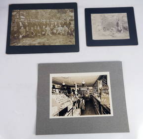
MATTHEWS c1856 Map Of Upper Canada Ontario Indian Land Agency Divisions Scarce!Luis Porretta Fine Arts4.3(10)See Sold PriceMar 02, 2024
DEVINE c1856 Dr Salters Map Of Lake Huron Ontario Indian Lands etc. No. 7 ScarceLuis Porretta Fine Arts4.3(10)See Sold PriceMar 02, 2024
DUNLEVIE c1856 Map Counties Of Gaspe & Bonaventure Quebec Canada SCARCE! #1Luis Porretta Fine Arts4.3(10)See Sold PriceMar 02, 2024
DUNLEVIE c1856 Map Counties Of Gaspe & Bonaventure Quebec Canada SCARCE! #2Luis Porretta Fine Arts4.3(10)See Sold PriceMar 02, 2024
Map UNITED COUNTIES LEEDS & GRENVILLE by Walling 1861 Rare Canada Map 5ft x 5ftLuis Porretta Fine Arts4.3(10)See Sold PriceMar 02, 2024
Ambroise TARDIEU c1822 Map Venice Napoleon Italian Campaign 17" x 11"Luis Porretta Fine Arts4.3(10)See Sold PriceMar 02, 2024
SoldMeyer: Antique Pre-Civil War Map of Deep South, 1853Map: Die Staaten von Arkansas, Mississippi, Louisiana & Alabama Cartographer: Bibliographischen Instituts. Place & Date: Hildburghausen / 1853 Size: 10 5/8" x 7 7/8" Condition: original color; overallSee Sold Price
Antique Map of Pre-Civil War Deep South, 1853Map: Die Staaten von Arkansas, Mississippi, Louisiana & Alabama Cartographer: Bibliographischen Instituts. Place & Date: Hildburghausen / 1853 Size: 10 5/8" x 7 7/8" Condition: original color; overallSee Sold Price
SoldColton: Antique Pre Civil War Map South Carolina, 1861Title/Content of Map: Pre Civil War South Carolina by Colton Date Printed: 1861 Cartographer: J.H. Colton Material/Medium: Paper Size: 17 1/2" x 14" Hand colored steel engraved Map from 'Colton's GeneSee Sold Price
Meyer: Pre-Civil War Deep South/New Orleans InsetCartographer: Bibliographischen Instituts. Place/Date: Hildburghausen / 1850 Size: 10 5/8" x 7 7/8" Condition: original outline color; overall age toning The highly detailed, well colored map of the dSee Sold Price
SoldPhelps: Antique Pre-Civil War Map of United States 1848Patriotic Antique Pre-Civil War US Map; "Phelps's National Map of the United States, A Travellers Guide. Embracing the principal Rail Roads, Canals, Steam Boat & Stage Routes, Throughout the Union.".See Sold Price
SoldYoung: Antique Pre Civil War Map of Virginia, 1851Title/Content of Map: Pre Civil War rare Tourist Map of Virginia Date Printed: 1851-1859 Cartographer: J. Young Material/Medium: Paper Size: 16" x 13 1/2" Condition: Excellent Hand colored. A rare PocSee Sold Price
SoldAntique Ensign's Travelers Guide & Map of the U.S. 1846, Wall MapAntique Pre-Civil War Wall Map of the U.S. Entitled ENSIGN'S TRAVELERS GUIDE & MAP OF THE U.S. | Published: New York: T & E. H. Ensign, 1846.See Sold Price
SoldPre Civil War South Carolina Map Charleston 1847Original hand colored map in overall good condition. Not a repro or restrike. Recently matted and framed using conservation materials. Framed dimensions 23 x 19 inches.See Sold Price
SoldAN ANTIQUE CIVIL WAR MAP, "Colton's Map of the SouthernAN ANTIQUE CIVIL WAR MAP, "Colton's Map of the Southern States," NEW YORK, CIRCA 1862, "...including Maryland, Delaware, Virginia, Kentucky, Tennessee, Missouri, North Carolina, South Carolina, GeorgiSee Sold Price
SoldMeyer: Pre–Civil War GeorgiaReserve Reduced! Map Title: Neuste Karte von Georgia 1850 Cartographer: Bibliographischen Instituts. Place / Date: Hildburghausen / 1849/1857 Size: 11 3/4" x 14 1/2" Condition: original color; light oSee Sold Price
SoldMeyer: Pre–Civil War AlabamaMap Title: Neuste Karte von Alabama Cartographer: Bibliographischen Instituts. Place & Date: Hildburghausen / 1845 Size: 11 3/4" x 14 5/8" Condition: original color; staining in lower right margin andSee Sold Price
SoldMeyer: Pre–Civil War GeorgiaMap Title: Neuste Karte von Georgia Cartographer: Bibliographischen Instituts. Place & Date: Hildburghausen / 1845 Size: 11 3/4" x 14 1/2" Condition: wash color; light age toning; light smudge under tSee Sold Price
SoldMeyer: Pre–Civil War AlabamaMap Title: Neueste Karte von Alabama 1850 Cartographer: Bibliographischen Instituts. Place/Date: Hildburghausen / 1849/1857 Size: 11 3/4" x 14 5/8" Condition: original outline color; minor spotting moSee Sold Price
Meyer: Pre–Civil War AlabamaReserve Reduced! Map Title: Neueste Karte von Alabama 1850 Cartographer: Bibliographischen Instituts. Place / Date: Hildburghausen / 1849/1857 Size: 11 3/4" x 14 5/8" Condition: original outline colorSee Sold Price
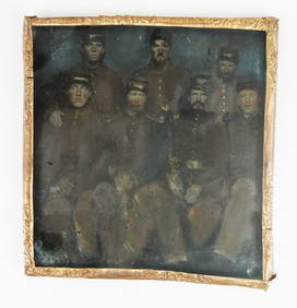
Sold1866 Wild Western Scenes Illustrated Adventures Daniel1866 Wild Western Scenes Illustrated Adventures Daniel Boone Slavery HUNTING J.B. Jones was a pre-civil war political journalist with deep roots in the American South. Jones’s views were pro-slaverySee Sold Price
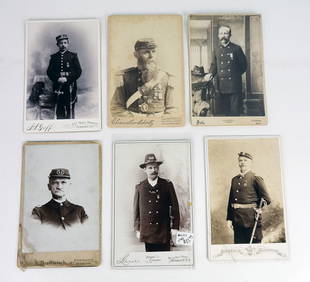
SoldDartmouth Graduate, Joel Hough, Pre and Early CivilDartmouth Graduate, Joel Hough, Pre and Early Civil War-Period Archive written from the Deep South 17 items. Archive of letters from teacher and minister Joel J. Hough as a young man employed as a pSee Sold Price
Pre civil war Southern States. 1846 by MitchellTitle: Pre civil war Southern States. 1846 by Mitchell Date/Period: 1846 Materials: Hand colored engraved Size: 11 1/2 x 17 1/2" Pre civil war map shows the southern states of North Carolina, South CaSee Sold Price
Civil War era map of deep southern states, 1860/62Authentic vintage map of three deep south states whose partial borders are defined by the mighty Mississippi River, one of the greatest rivers in the world. This map is dated 1860 and was included asSee Sold Price
Sold1860 Life of John Quitman American Mexican War South1860 Life of John Quitman American Mexican War South Slavery Illustrated MAP A rare pre-Civil War printing of Claiborne’s “Life and Correspondence of John A. Quitman.” This book is a telling ofSee Sold Price
SoldMeyer: Tennessee, 1849/ Nashville & Knoxville InsetsThe beautifully detailed and colored map of pre-Civil War Tennessee, from Meyer's Auswanderungs-Atlas (Emigrant's Atlas) of North America. Includes a key to canals, railroads, and main roads; steamshiSee Sold Price
MAP OF THE NORTHEASTERN UNITED STATES BY G.H. SWANSTONPre-Civil War hand-colored lithograph map, 23' x 18 3/4', a depiction of the northeastern United States including all of New England, the eastern seaboard as far south as Maryland, extending westwardSee Sold Price
SoldAntique Print President Abraham Lincoln Pre Civil WarHere is an early depiction of President Lincoln, without his typical beard and hat, in his hometown of Springfield. On the reverse is an article about the secession movement in the South. * * Title: "See Sold Price
Sold2 South Carolina Civil War Maps1st item: Map of the Defences of Charleston city and Harbor showing also the works erected by the U.S. Forces in 1863 and 1864. To accompany the Report of Major Q.A. Gillmore U.S. Vols. Plate II, withSee Sold Price
Sold1853 $1T-1 (pre-civil war) gold coin1853 $1 T-1 (pre-civil war) gold coin. Condition: AU. Very scarce coin.See Sold Price
Civil War Map, Positions of the Army of the Ohio Front oh Dalton GA Dated 1864 34"L x 24"TSwisher Bros. Auction LLC4.4(251)See Sold PriceFeb 24, 2024
Civil War Map, Positions of the 16th Army Corps Dated 1864 34"L x 24"TSwisher Bros. Auction LLC4.4(251)See Sold PriceFeb 24, 2024
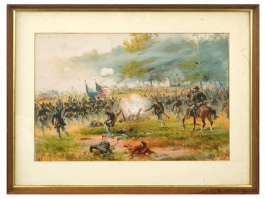
ANTIQUE AMERICAN CIVIL WAR LITHO BY THURE DE THULSTRUPAntique Arena Inc.4.5(866)See Sold PriceFeb 24, 2024
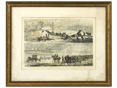
ANTIQUE AMERICAN CIVIL WAR ETCHINGS BY EDWIN FORBESAntique Arena Inc.4.5(866)See Sold PriceFeb 24, 2024
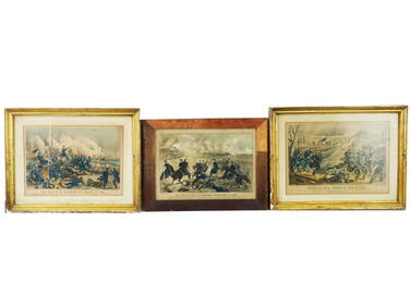
ANTIQUE AMERICAN CIVIL WAR LITHO BY THURE DE THULSTRUPAntique Arena Inc.4.5(866)See Sold PriceFeb 24, 2024
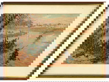
ANTIQUE AMERICAN CIVIL WAR HAND COLORED LITHOGRAPHSAntique Arena Inc.4.5(866)See Sold PriceFeb 24, 2024
Pre-SECOND WORLD WAR AFRICA. European colonies & German mandates 1942 old mapJasper524.5(9.8k)See Sold PriceFeb 28, 2024
T. Kelly - Plan of Bruseels - Battle of Waterloo, London - History of the French RevolutionProverde Auctions4.3(3)See Sold PriceFeb 28, 2024
1995-S 50c Civil War Battlefield Preservation Commemorative Half Dollar BUAndrew's Coin & Jewelry4.5(209)See Sold PriceMar 07, 2024