MATTHEWS c1856 Map Of Upper Canada Ontario Indian Land Agency Divisions Scarce!Luis Porretta Fine Arts4.3(10)See Sold PriceMar 02, 2024
DEVINE c1856 Dr Salters Map Of Lake Huron Ontario Indian Lands etc. No. 7 ScarceLuis Porretta Fine Arts4.3(10)See Sold PriceMar 02, 2024
DUNLEVIE c1856 Map Counties Of Gaspe & Bonaventure Quebec Canada SCARCE! #1Luis Porretta Fine Arts4.3(10)See Sold PriceMar 02, 2024
DUNLEVIE c1856 Map Counties Of Gaspe & Bonaventure Quebec Canada SCARCE! #2Luis Porretta Fine Arts4.3(10)See Sold PriceMar 02, 2024
Map UNITED COUNTIES LEEDS & GRENVILLE by Walling 1861 Rare Canada Map 5ft x 5ftLuis Porretta Fine Arts4.3(10)See Sold PriceMar 02, 2024
Ambroise TARDIEU c1822 Map Venice Napoleon Italian Campaign 17" x 11"Luis Porretta Fine Arts4.3(10)See Sold PriceMar 02, 2024
Tallis/Rapkin: Antique Map of the United States, 1851Title/Content of Map: 'United States' The map shows 30 of the then 31 states of the United States (the other being California), plus Minnesota territory (which became the 32nd state in 1858), and NebrSee Sold Price
SoldTallis/Rapkin: Antique Map of the United States, 1851TITLE/CONTENT OF MAP: 'United States' The map shows 30 of the then 31 states of the United States (the other being California), plus Minnesota territory (which became the 32nd state in 1858), and NebrSee Sold Price
Tallis/Rapkin: Antique Map of the United States, 1851Title/Content of Map: 'United States' The map shows 30 of the then 31 states of the United States (the other being California), plus Minnesota territory (which became the 32nd state in 1858), and NebrSee Sold Price
Tallis / Rapkin: Antique Map of the United States, 1851Title/Content of Map: 'United States' The map shows 30 of the then 31 states of the United States (the other being California), plus Minnesota territory (which became the 32nd state in 1858), and NebrSee Sold Price
SoldTallis: Antique Map of the United States, 1851Title: 1851 Tallis Map of the United States -- United States Cartographer: J. Tallis Year / Place: 1851 London Map Dimensions: 10.5 x 14 in. Condition: Very Good. Slight age toning in margins and in iSee Sold Price
SoldTallis/Rapkin: Antique Map of North America, 1849Title/Content of Map: 'North America' The map shows the then 30 states of the United States, plus Minnesota territory (which became the 32nd state in 1858), Nebraska Territory (eventually divided betwSee Sold Price
SoldTallis / Rapkin: Antique Map of Northern Italy, 1851Title/Content of Map: 'Northern Italy' Vignettes: The Grand Canal - Venice; St. Peter's - Rome; Religious Procession. Shows railways. Sardinian/Papal States.Venetian Lombardy Date Printed: 1851 ImageSee Sold Price
SoldTallis/Rapkin: Map of Greece, Ionian Islands, 1851Title/Content of Map: 'Greece' The map shows Greece, with the Ionian Islands coloured in red. The United States of the Ionian Islands (Greek: ) was a state and amical protectorate of the United KingdoSee Sold Price
SoldTallis/Rapkin: Antique Map of Japan & Korea, 1851TITLE/CONTENT OF MAP: 'Japan & Corea' Tokyo and Seoul are both marked o the map under their historic names of Yedo & King-ki-Tao respectively. Vignettes: Yedo; Coreans; State Barge. Marked on the mapSee Sold Price
Tallis/Rapkin: Antique Map of Japan & Korea, 1851Title/Content of Map: 'Japan & Corea' Tokyo and Seoul are both marked o the map under their historic names of Yedo & King-ki-Tao respectively. Vignettes: Yedo; Coreans; State Barge. Marked on the mapSee Sold Price
U.S. Coast Survey: Antique Coast Survey Atlas for 1851Title/Content of Map: Sketches Accompanying the Annual Report of the Superintendent of the United States Coast Survey 1851. Date Printed: 1851 Cartographer: U.S. Coast and Geodetic Survey Size (inchesSee Sold Price
Sold2 Travel Maps of US: Atwood Pocket Map 1851 & Williams Framed, 18541st item: PHELPS'S NATIONAL MAP OF THE UNITED STATES, TRAVELLERS GUIDE. EMBRACING THE PRINCIPAL RAIL ROADS, CANALS, STEAM BOAT & STAGE ROUTES THROUGHOUT THE UNION, by J. M. Atwood, published by ThayerSee Sold Price
SoldAntique map, "United States of America", by JohnAntique map, "United States of America", by John Melish, 1818, Compiled from the latest and best authorities, 16.25" by 19.5". Notice: Please note that our auctions will continue in the online only foSee Sold Price
SoldAN ANTIQUE MAP, "United States (South Central),"AN ANTIQUE MAP, "United States (South Central)," LIVERPOOL, GREAT BRITAIN, 1891-1917, a color engraving on paper,"Philips' Authentic Imperial Maps for Tourists and Travelers," printed by George PhilipSee Sold Price
SoldAntique Map United States Thomson's 1817Antique Map United States Thomson's 1817, authentic antique map, inscribed, "drawn & engraved for Thomson's new general atlas 1817", along with "Northern Provinces of the United States", hand coloredSee Sold Price
SoldAN ANTIQUE MAP, "United States of America," NEW YORK,AN ANTIQUE MAP, "United States of America," NEW YORK, 1827, hand colored engraving on paper, engraved by Benjamin Tanner (1775-1848). 17" X 21 5/8" Note: This map unusually shows two locations for GalSee Sold Price
SoldAN ANTIQUE MAP, "United States," BOSTON, CIRCA 1838,AN ANTIQUE MAP, "United States," BOSTON, CIRCA 1838, hand colored engraving on paper, showing Texas as an independent nation, a page fragment from an atlas, Thomas Gamaliel Bradford (1802-1887) cartogSee Sold Price
SoldAN ANTIQUE MAP, "United States of North America,AN ANTIQUE MAP, "United States of North America, Southwest Sheet," 1893-1912, color engraving on paper, engraved, printed and published by W. & A.K. Johnston, Edinburgh and London, showing parts BajaSee Sold Price
SoldAN ANTIQUE MAP, "United States of North America,AN ANTIQUE MAP, "United States of North America, Southwest Sheet," 1893-1912, color engraving on paper, engraved, printed and published by W. & A.K. Johnston, Edinburgh and London, showing parts BajaSee Sold Price
Sold1848 Ensigns & Thayer ANTIQUE MAP UNITED STATES ANDDetails: This lot is the antique hand-colored engraved wall map shown in the corresponding images. This map is entitled, “Ornamental Map of the United States & Mexico,†and is dated 1848, pSee Sold Price
SoldSchiaparelli: Antique Map United States & Mexico, 1890Very beautiful map of United States and Mexico coloured by hand Author: Schiaparelli Luigi (1816-1897) - Mayr, E. Atlas: Atlante Moderno Date: 1890 circa Technique: Lithography Leaf Dimension: 44x32 cSee Sold Price
Antique Map : United States - 1897Antique Map : United States - 1897 from The Century Atlas. Has some loss at the center crease. Size : 16" x 11.75"See Sold Price
Sold18thc Map: United States of America, Wilkes, 1797Framed antique map, United States of America, Published London 1797 by J. Wilkes. Engraved by Neele, 352 Strand, London. Hand colored, the map shows the United States in the Decade after the AmericanSee Sold Price
SoldT.G Bradford: Antique Map of United States, 1838Title: Map of United States by T.G Bradford Date: 1838 Medium: Wax Engraving Dimensions (in): 25 x 16 Condition: Excellent Condition Thomas G. Bradford was the author of the Illustrated Atlas of the USee Sold Price
Arrowsmith & Lewis - Map of the United StatesTrillium Antique Prints & Rare Books4.5(32)See Sold PriceFeb 24, 2024
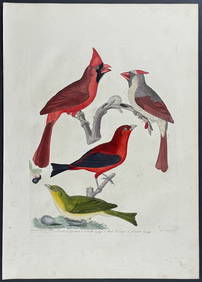
Wilson - Cardinal Grosbeak & Red Tanager. 11Trillium Antique Prints & Rare Books4.5(32)See Sold PriceFeb 24, 2024
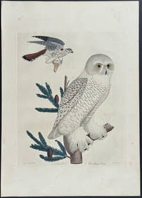
Wilson - Snow Owl (Snowy Owl) & Sparrow Hawk. 32Trillium Antique Prints & Rare Books4.5(32)See Sold PriceFeb 24, 2024
Wilson - Ivory-billed Woodpecker, Red-headed & Pileated Woodpeckers. 29Trillium Antique Prints & Rare Books4.5(32)See Sold PriceFeb 24, 2024
Wilson - Carolina Parrot & Flycatchers. 26Trillium Antique Prints & Rare Books4.5(32)See Sold PriceFeb 24, 2024
Cooke, George 1801 Antique Map. United States of AmericaAlbion Auctions4.6(341)See Sold PriceMar 01, 2024
Blackie (Pub) 1882 Folio Map. West USA - Pacific StatesAlbion Auctions4.6(341)See Sold PriceMar 01, 2024
Blackie (Pub) 1882 Folio Map. United States of North AmericaAlbion Auctions4.6(341)See Sold PriceMar 01, 2024