SoldEarly Hand Colored Map of FranceFramed hand colored map of France; 16.5in. X 22in.(image size)See Sold Price
SoldEarly Hand Colored Map of FranceEarly hand colored map of France dated 1628 covering the provinces Orange and Avignon 15.75"H x 20"WSee Sold Price
SoldEarly Hand Colored Map of FranceFramed hand colored map of France; 20.75in. X 20.25in.(image size)See Sold Price
SoldAntique Map Bay of Biscay France, 1833Beautiful early hand colored map in a 24" by 20" frame. Nice details and toning. ExcellentSee Sold Price
SoldChez Pierre Vander, "Nouvelle France," MapChez Pierre Vander, "Nouvelle France," hand colored early map of Canada, matted and framed, 10" h x 15" w (view), 15 1/2" h x 20" w (frame). Provenance: From a Massachusetts estate.See Sold Price
Chez Pierre Vander, "Nouvelle France," MapChez Pierre Vander, "Nouvelle France," hand colored early map of Canada, matted and framed, 10" h x 15" w (view), 15 1/2" h x 20" w (frame). Provenance: From a Massachusetts estate.See Sold Price
SoldLot of 2 Early Hand Colored Engraved MapsLot of two early hand colored engraved maps, to include: "Andegaver Sium Ditionis Vera et Integra Descripto," dated 1579, map of Anjou, France, 13 3/4" h x 18 3/8" w (view), 19" h x 23 5/8" w (frame)See Sold Price
SoldAntique 1806 Robert de Vaugondy Map of FranceAntique 1806 Robert de Vaugondy Map of France. Antique early 19th century hand colored engraving. Framed and matted. Measures 14.5 x 17 inches.See Sold Price
SoldABRAHAM ORTELIUS 17TH C BURGUNDY FRANCE MAPABRAHAM ORTELIUS 17TH C BURGUNDY FRANCE MAP Hand colored decorative regional map of France, early 17th C., centered on Besancon, Poligny, Quingey and St Anne. Includes a number of famous wine regions.See Sold Price
SoldJan Jansson Early Map Views France (2)Early maps: Jan Jansson. Calais and Lyon. (2) Map Views in France. Hand-colored engravings. From Theatrum exhibens celebriores Galliae et Helvetiae. Amsterdam, C. 1650s. 19" x 23".See Sold Price
Sold1755 Hand-Colored Map by Jacques Nicolas BellinHistoric Maps Choice 1755 Hand-Colored Map by Jacques Nicolas Bellin 1755. Hand-Colored Double-Sheet Map titled, “PARTIE ORIENTALE DE LA NOUVELLE FRANCE OU DU CANADA” by Jacques Nicolas Bellin, PuSee Sold Price
Sold1755 Choice Bellin Handcolored Double-Sheet MapHistoric Maps Choice 1755 Hand-Colored Map by Jacques Nicolas Bellin 1755. Hand-Colored Double-Sheet Map titled, “PARTIE ORIENTALE DE LA NOUVELLE FRANCE OU DU CANADA” by Jacques Nicolas Bellin, PuSee Sold Price
SoldEARLY MAP OF FRANCE - "Utriusque Burgundiae Tum DucatusEARLY MAP OF FRANCE - "Utriusque Burgundiae Tum Ducatus Tum Comitatus Descriptio:, Willem Janszoon Blaeu, Amsterdam 1631, handcolored copperplate engraving, title cartouche appears at lower right withSee Sold Price
SoldBlaeu Early Map Sedan Northern FranceEarly map: Les Souverainetez de Sedan et de Raucourt. Hand-colored engraving. Blaeu, Amsterdam, 17th Century. 20" x 24".See Sold Price
Sold2 Early Maps, Britain and FranceTwo (2) Early Maps, Britain and France. 1st item: L'ISLE DE FRANCE, PARISIENSIS AGER, hand colored and engraved map showing the areas around Paris with small tree illustrations to denote forests; undaSee Sold Price
1771 2 Maps of Canada and Colonies1771 Matching Set of Maps of Canada and American Colonies 1771, "PARTIE DE L'AMERIQUE..." & "CANADA...," by Rigobert Bonne, Lot of 2, Paris, France, Choice Near Mint. Set of two maps, handcolored in oSee Sold Price
Soldc. 1650 MOSCOVI, Map of Moscow and LithuaniaMapsc. 1650 Map of “Moscow” and Lithuania c. 1650 “MOSCOVI”, Map of Moscow & Lithuania, [France?], Choice Very Fine. Handcolored in outline, 5” x 6.75” image on 6.5See Sold Price
SoldDidier Robert de Vangondy, early map CanadaDidier Robert de Vangondy, early map Canada, Didier Robert de Vangondy (French, 1723-1786), "Partie de L'Amerique Septent qui comprend La Nouvelle France ou le Canada", c. 1765, hand-colored engravingSee Sold Price
Moll's Map of EuropeAn early 18th century map of Europe "To Her most Sacred Majesty Carolina, Queen of Great Britain, France & Ireland". By Herman Moll, published 1708 by John Bowles. Hand colored engraving on paper. OveSee Sold Price
Sold[Early Louisiana Map] Robert de Vaugondy, 1762[Early Louisiana Map] Robert de Vaugondy, 1762, Paris, @Canada, Louisiane, Possessions Angl,@ hand colored, decorative title cartouche, featuring the colonial possessions of France, England and SpainSee Sold Price
SoldThree early mapsFrance, "Galliae Regni Potentiss: Nova Descriptio Ioanne Ioliveto Auctore," hand colored, text verso, paper reinforcing tape on fold crease and at top verso, scattered browning, original edges,14-3/4See Sold Price
SoldEarly Hand Colored Map North America by T ConderAntique framed hand colored early map of North America. Top left image of Native man and foliage, reads "North America agreeable to the most approved Maps and Charts, by Thomas Condor" Frame: 14 3/4 iSee Sold Price
SoldEarly Hand Colored Map of ScotlandFramed hand colored map of Scotland; 23in. X 19in.See Sold Price
SoldEarly hand-colored map of New Jersey, c.1775. 13.Early hand-colored map of New Jersey, c.1775. 13.75”x11.75”See Sold Price
LARGE LATE 17TH C. DUTCH CHART OF CANADA, GREAT LAKES, NEW FRANCE, LABRADOR, HUDSON BAY, BY PIERREThomaston Place Auction Galleries4.4(389)See Sold PriceFeb 24, 2024
EARLY 18TH C. DUTCH CHART OF PACIFIC OCEAN BY FREDERIK DE WIT (1629-1706) WITH CALIFORNIA AS ANThomaston Place Auction Galleries4.4(389)See Sold PriceFeb 24, 2024
17TH C. ANTIQUE MAP SIEGE OF LA ROCHELLE, FRANCE, FRAMEDThomaston Place Auction Galleries4.4(389)See Sold PriceFeb 24, 2024
EARLY 18TH C. MAP OF ITALY, FRAMEDThomaston Place Auction Galleries4.4(389)See Sold PriceFeb 24, 2024
ABRAHAM ORTELIUS (1527-1598) MAP OF ROMAN GAUL (FRANCE)Thomaston Place Auction Galleries4.4(389)See Sold PriceFeb 24, 2024
Early 1900's Railway Service Map, Illinois, Ohio, Indiana, Kentucky, TennesseeConnoisseur Auctions3.9(335)See Sold PriceFeb 24, 2024
An early Dutch hand colored engraving map by Georg Balthasar Probst (1732-1801)Ostantix Auctions4.4(10)See Sold PriceFeb 27, 2024
Framed Hand Colored Antique Map of the Department of Nord, FranceDonny Malone Auctions4.4(1.8k)See Sold PriceMar 04, 2024
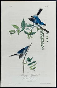
Audubon - Blue-grey Flycatcher. 70Trillium Antique Prints & Rare Books4.5(30)See Sold PriceFeb 24, 2024
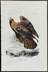
Audubon - Common Osprey Fish Hawk. 15Trillium Antique Prints & Rare Books4.5(30)See Sold PriceFeb 24, 2024
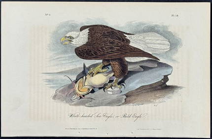
Audubon - White-headed Sea Eagle or Bald Eagle. 14Trillium Antique Prints & Rare Books4.5(30)See Sold PriceFeb 24, 2024
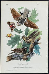
Audubon - Little Screech Owl. 40Trillium Antique Prints & Rare Books4.5(30)See Sold PriceFeb 24, 2024
Galliae Regionis Nova Descriptio Hand Colored Map of France on Laid Paper, Ca. 16th Century, H 10" WDuMouchelles4.6(829)See Sold PriceMar 15, 2024


![[Early Louisiana Map] Robert de Vaugondy, 1762 (1 of 1)](https://p1.liveauctioneers.com/268/2586/1120905_1_x.jpg?height=282&quality=70)