SoldJOHN STOCKDALE (BRITISH, 1750-1814) MAP OF THE UNITEDJOHN STOCKDALE (BRITISH, 1750-1814) MAP OF THE UNITED STATES hand-colored engraving on paper, "Part of the United States of North America", published 1798 in London. Retains period color outlining. MaSee Sold Price
SoldJohn Stockdale, Plan of the City of WashingtonJohn Stockdale (British, 1750-1814) paper and ink. It is captioned 'Plan of the City of Washington, published in Piccadilly, 16 September 1794.' Dimensions: sight size-7 3/4 inches tall X 9 3/4 inchesSee Sold Price
SoldJOHN STOCKDALE (BRITISH, 1750-1814) PLANTATION PRINTJOHN STOCKDALE (BRITISH, 1750-1814) PLANTATION PRINT, hand-colored engraving, possibly a West Indies scene, titled "A NEGRO FESTIVAL drawn from Nature in the Island of St. Vincent.", after a paintingSee Sold Price
SoldJ. Gibson North America MapJohn Gibson, British, 1750-1792. Engraved map of North America with "Degrees of Longitude West from London" and "Hours of Time West from London". Not examined out of the frame. Minor creasing evident.See Sold Price
SoldJ. Gibson Map of British N. AmericaJohn Gibson, British, 1750-1792. Engraved map entitled "An Accurate Map of the British Empire in Nth. America as Settled by the Preliminaries in 1762". Not examined out of the frame. Some creasing. ImSee Sold Price
SoldJ. Gibson Map of the WorldJohn Gibson, British, 1750-1792. Engraved map entitled "The World" with "Plate 126 No. 59 Page 1" at the lower left and "J. Gibson sculp.t" at the lower right. Not examined out of the frame. Creased,See Sold Price
SoldPINKERTON 1814 LITHOGRAPHIC MAP OF ASIAJohn Pinkerton British 1758-1826 - 1814 Map of Asia. Lithographic map with colored borders. H 20" x L 27" matted sight size.See Sold Price
SoldBritish Isles.- Stockdale (John) Map of England & WalesBritish Isles.- Stockdale (John) Map of England & Wales from the Latest Surveys, highly detailed 20 sheet map by Samuel Neele, engravings, loose and mounted on linen support, each sheet approx. 605 xSee Sold Price
Sold1794 Map of Virginia, Maryland and Deleware by Jedidiah MorseMap of Virginia, Maryland and Deleware. Issued in 1794. Authored by Jedidiah Morse (1761-1826) and published by John Stockdale (1749?-1814). Frame size: 17 1/4" H x 25 5/8" W x 3/4" D. Sight size: 10See Sold Price
Sold(2) ATLAS MINIMUS MAP PAGES, J. GIBSON & E. BOWEN(lot of 2) Framed hand colored pages from the Atlas Minimus by John Gibson (British, 1750-1792) and improved by Emanuel Bowen (English, 1694?-1767), comprising: (1) "Turky in Asia", plate 30; (1) "EgySee Sold Price
SoldMorse - Virginia, Maryland, and Delaware, 1794Jedidiah Morse (1761-1826), Map of Virginia Maryland and Delaware, 1794, John Stockdale (1749?-1814) publisher, black and white line engraving on laid paper, 10-1/4 x 20-1/8 in. (overall); unframed NSee Sold Price
SoldCary Map of Florida, Georgia, North Carolina, SouthCary, John (British, 1754-1835). A New Map of Part of the United States of North America, Containing the Carolinas and Georgia, also the Floridas and Part of the Bahama Islands. London: 1806. EngravedSee Sold Price
SoldCary Map of the Western Territory, Kentucky,Cary, John (British, 1754-1835). A New Map of Part of the United States of North America, Exhibiting the Western Territory, Kentucky, Pennsylvania, Maryland, Virginia &c. Also, the Lakes Superior, MicSee Sold Price
SoldJohn Cary (British, 1754-1835)John Cary (British, 1754-1835), "A New Map of Part of The United States of North America Containing the Carolinas and Georgia, also The Floridas and Part of The Bahama Islands & C.", London, 1806, hanSee Sold Price
SoldTwo Early English Maps of the United States,Two Early English Maps of the United States, GUTHRIE, William. – DARTON, William. A Map of the United States of America, Agreeable to the Peace of 1783. and GIBSON, John. The British Governments inSee Sold Price
SoldEarly map of South Carolina by J. RoperEarly map of South Carolina by J. Roper British, circa 1794A MAP OF SOUTH CAROLINA FROM THE BEST AUTHORITIEScolored engraving, unframed, by J. Roper, and published by John Stockdale, Londonimage size:See Sold Price
SoldEarly map of South Carolina by J. RoperEarly map of South Carolina by J. Roper British, circa 1794A MAP OF SOUTH CAROLINA FROM THE BEST AUTHORITIEScolored engraving, unframed, by J. Roper, and published by John Stockdale, Londonplate size:See Sold Price
Sold* MELISH, John. Map of the United States with the* MELISH, John (1771-1822). Map of the United States with the contiguous British & Spanish Possessions. Philadelphia: John Melish, 1816. Engraved folding map by J. Vallance and H.S. Tanner, overall 90See Sold Price
SoldJohn Gibson (fl.1750-1792) British. "The Road fromJohn Gibson (fl.1750-1792) British. "The Road from London to Cambridge, Ely & King's Lynn", Map, 7" x 11.5", and a companion piece "A Map of the Roads from London to Dover, Rye, Hith, Margate, RamsgatSee Sold Price
SoldRobert Sayer (act.1750-1780) British. “An Accurate Map Robert Sayer (act.1750-1780) British. “An Accurate Map of the County of Sussex”, Map, 21.5” x 28.5”.See Sold Price
SoldLOSKIEL, George Henry (1740-1814). History of the Mission of the United Brethren Among the IndiansLOSKIEL, George Henry (1740-1814). History of the Mission of the United Brethren Among the Indians in North American. John Stockdale, London: for the Brethren's Society for the Furtherance of the GospSee Sold Price
John Stockdale: United States 1800Map: heil der Vereinigten Staaten von Nord America. (United States) Maker: John Stockdale Publishing: Germany Date: 1800 Size: 16 x 18.25 inches Medium: Copperplate engraving Hand colored Map of the eSee Sold Price
SoldAfter William Beechey (1753-1839) British. ‘Here PoorAfter William Beechey (1753-1839) British. ‘Here Poor Boy without a Hat, Take this Ha’penny’, Engraving by Charles Wilkin (1750-1814), in a Maple Frame, overall 20.5” x 16.5”.See Sold Price
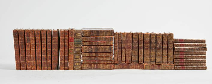
SoldNapoleonica /Atlante - [J. Cary]. New British AtlaNapoleonica /Atlante - [J. Cary]. New British Atlas being a complete set of County Maps..Londra, John Stockdale, 1805. In 2° imperiale. 51 tavole litografiche incise da John Cary, al fronSee Sold Price
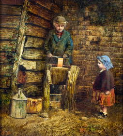
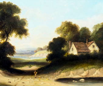
John Henry Dell (UK,1836-1888) oil painting antiqueBroward Auction Gallery4.7(292)See Sold PriceMar 17, 2024
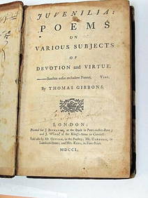
Thomas Gibbons Juvenalia 1750 Very Rare 1st Edition Full CalfLuis Porretta Fine Arts4.3(10)See Sold PriceMar 02, 2024
SAMUEL AYSCOUGH Remarkable Passages In Shakespeare 1st 1790 Edition Full CalfLuis Porretta Fine Arts4.3(10)See Sold PriceMar 02, 2024
HONEST JOHN OLIVER by James Morton 1st Edition Inscribed by Author ScarceLuis Porretta Fine Arts4.3(10)See Sold PriceMar 02, 2024
Arrowsmith & Lewis - Map of the United StatesTrillium Antique Prints & Rare Books4.5(32)See Sold PriceFeb 24, 2024
Fielding (Henry) The Works, with An Essay on His Life and Genius by Arthur Murphy, 10 vol., newForum Auctions4.3(53)See Sold PriceFeb 29, 2024
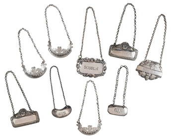
Nine English Silver Decanter Labels, Several Bateman FamilyBrunk Auctions4.6(470)See Sold PriceMar 07, 2024
John Joseph Cotman (UK,1814-1878) oil painting antiqueBroward Auction Gallery4.7(292)See Sold PriceMay 19, 2024
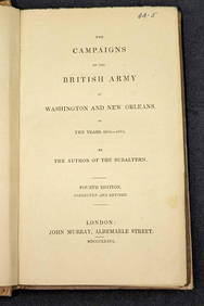
1836 The British Army at Washington & New Orleans HCRapid Estate Liquidators and Auction Gallery4.5(1.1k)See Sold PriceFeb 29, 2024


![Napoleonica /Atlante - [J. Cary]. New British Atla (1 of 2)](https://p1.liveauctioneers.com/676/25321/9299787_1_x.jpg?height=282&quality=70&version=1307370860)