SoldWeller (E.) London map after AgasWeller (Edward) London in the Reign of Queen Elizabeth,A Fac-simile (Reduced) of the Map by Aggas, 1560, bird's-eye plan/view of London, with decorative title cartouche lower left, key panel lSee Sold Price
1863 Weller Map of Cheshire -- CheshireTitle: 1863 Weller Map of Cheshire -- Cheshire Cartographer: E Weller Year / Place: 1863 c., London Map Dimension (in.): 11.8 X 16.6 in. This is a larger, highly detailed map of the County of CheshireSee Sold Price
SoldLondon.- Weller (Edward) London, engraved map, [1863].London.- Weller (Edward) London, large folding map on a scale of 9 1/2" to the mile, engraving with hand-colouring, 1430 x 1955 mm (56 1/4 x 77 in), dissected and mounted on linen, some surface dirt,See Sold Price
Europe in 1871.Publication Date: c1877 Title: Europe in 1871. Cartographer: WELLER, EDW. Publisher: G.P. PUTNAM'S SONS Height: 5.8 Width: 8.6 "by Edwd. Weller, F.R.G.S." London printed map from the New York editionSee Sold Price
SoldWeller (Edward) LondonWeller (Edward) London,large wall map issued with the Dispatch Atlas, lithographed map with full original hand-colouring, 1390 x 1920mm., dissected and linen-backed, slight browning and surfacSee Sold Price
SoldWeller (Edward) LondonWeller (Edward) London,large wall map issued in the Dispatch Atlas, engraved map with hand-colouring, on 9 sheets, joined, 1380 x 1895mm., old central fold to each sheet, minor hadling creasesSee Sold Price
SoldWeller (Edward) LondonWeller (Edward) London,large detailed map, from Highbury Vale to Kennington and Bromley to Kensington, for The Daily Dispatch, lithographed map with full original hand-colouring, 1400 x 1930mmSee Sold Price
1846 Quin Map of the Mediterranean and Persia During the Rule of Cyrus -- Fourth period : B.C. 529.Title: 1846 Quin Map of the Mediterranean and Persia During the Rule of Cyrus -- Fourth period : B.C. 529. The Empire Of Cyrus Cartographer: E Quin Year / Place: 1846, London Map Dimension (in.): 13.2See Sold Price
1846 Quin Map of The Empire Of Alexander the Great --Reserve Reduced! Map Title/Content: 1846 Quin Map of The Empire Of Alexander the Great -- Fifth period : B.C. 323. The Empire Of Alexander Cartographer: E Quin Year / Place: 1846, London Map DimensionSee Sold Price
Brightly / Kinnersley: Map of Euro Russia, 1806Map: 1806 Brightly and Kinnersley Map of Euro Russia -- Muscovy or Russia in Europe Cartographer: C Brightly and E Kinnersley Year / Place: 1806, London Map Dimensions: 14 X 8.4 in. Condition: Very goSee Sold Price
1777 Bowen Map of County Kent, England -- An AccurateTitle: 1777 Bowen Map of County Kent, England -- An Accurate Map of the County of Kent, Divided into its Lathes… Cartographer: E Bowen Year / Place: 1777, London Map Dimension (in.): 16 X 19.6 in. TSee Sold Price
1777 Bowen Map of County Kent, England -- An Accurate Map of the County of Kent, Divided into itsTitle: 1777 Bowen Map of County Kent, England -- An Accurate Map of the County of Kent, Divided into its Lathes… Cartographer: E Bowen Year / Place: 1777, London Map Dimension (in.): 16 X 19.6 iSee Sold Price
1777 Bowen Map of County Kent, England -- An Accurate Map of the County of Kent, Divided into itsTitle: 1777 Bowen Map of County Kent, England -- An Accurate Map of the County of Kent, Divided into its Lathes… Cartographer: E Bowen Year / Place: 1777, London Map Dimension (in.): 16 X 19.6 iSee Sold Price
1777 Bowen Map of County Kent, England -- An AccurateTitle: 1777 Bowen Map of County Kent, England -- An Accurate Map of the County of Kent, Divided into its Lathes… Cartographer: E Bowen Year / Place: 1777, London Map Dimension (in.): 16 X 19.6 in. DSee Sold Price
1777 Bowen Map of County Kent, England -- An AccurateTitle: 1777 Bowen Map of County Kent, England -- An Accurate Map of the County of Kent, Divided into its Lathes… Cartographer: E Bowen Year / Place: 1777, London Map Dimension (in.): 16 X 19.6 in. TSee Sold Price
Bowen: Antique Map of England & Wales, 1747Map: 1747 Bowen Map of England and Wales -- A New and Very Accurate Map of South Britain or England and Wales... Cartographer: E Bowen Year / Place: 1847 c., London Map Dimensions: 15.5 X 16.5 in. ConSee Sold Price
Bowen: Map of England and Wales, 1747Map: 1747 Bowen Map of England and Wales -- A New and Very Accurate Map of South Britain or England and Wales... Cartographer: E Bowen Year / Place: 1847 c., London Map Dimensions: 15.5 X 16.5 in. ThiSee Sold Price
SoldEarly MapsLot (2) early unframed maps "WEST INDIES" (London, (E) Published By Charles Wilson..., 26" x 39 1/2"), "LONG ISLAND SOUND" (London, 27 1/4" x 40 1/4").See Sold Price
1750 Bowen Map of Surrey in UK - An Accurate Map Of TheTitle: 1750 Bowen Map of Surrey in UK - An Accurate Map Of The County of Surrey… Cartographer: E Bowen Year / Place: 1750 c., London Map Dimension (in.): 20.8 X 28 in. This is an outstanding, and veSee Sold Price
1750 Bowen Map of Surrey in UK - An Accurate Map Of TheTitle: 1750 Bowen Map of Surrey in UK - An Accurate Map Of The County of Surrey… Cartographer: E Bowen Year / Place: 1750 c., London Map Dimension (in.): 20.8 X 28 in. This is an outstanding, and veSee Sold Price
1750 Bowen Map of Surrey in UK - An Accurate Map Of TheTitle: 1750 Bowen Map of Surrey in UK - An Accurate Map Of The County of Surrey… Cartographer: E Bowen Year / Place: 1750 c., London Map Dimension (in.): 20.8 X 28 in. This is an outstanding, and veSee Sold Price
SoldMap Engraving - London - by Edward WellerMap Engraving - London - drawn & engraved by Edw. Weller - 19 1/2" x 17 1/2"See Sold Price
SoldStanford (E) Library Map of LondonStanford (Edward) Library Map of London and its Suburbs, 4 folding engraved linen-backed maps, each dissected into 20 sections with part original hand-colouring, each opening to 980 x 850mm.,See Sold Price
Weller: Antique Map of London & Brighton Railway, 1863TITLE/CONTENT OF MAP: 'London & Brighton Railway' The route (including all branches shown) runs through the towns of London Bridge, Crystal Palace, Croydon, Epsom, Chipstead, Redhill, East Grinstead,See Sold Price
OGILVY & BOWEN c1736 Original Map of Oxfordshire Berkshire Etc.Luis Porretta Fine Arts4.3(10)See Sold PriceMar 02, 2024
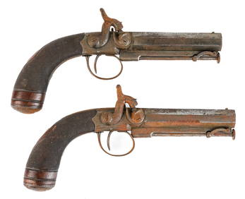
PAIR of PERCUSSION CAP PISTOLS made in LONDONJohn McInnis Auctioneers,LLC4.6(504)See Sold PriceFeb 25, 2024
SEYMOUR, Richard (d. ca. 1750). The Compleat Gamester: In T...Potter & Potter Auctions4.6(544)See Sold PriceFeb 24, 2024
MASKELYNE & COOKE. Maskelyne and Cooke. The Royal Illusioni...Potter & Potter Auctions4.6(544)See Sold PriceFeb 24, 2024
LEROY, Servais (Jean Henri Servais LeRoy, 1865 – 1953). A F...Potter & Potter Auctions4.6(544)See Sold PriceFeb 24, 2024
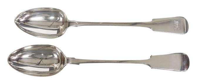
(2) ENGLISH STERLING SILVER & SILVERPLATE DRESSING SPOONSAustin Auction Gallery4.7(1.2k)See Sold PriceFeb 25, 2024
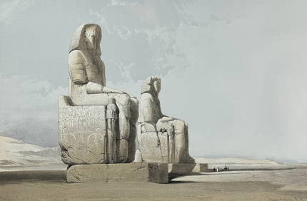
David Roberts - Obelisk of LuxorTrillium Antique Prints & Rare Books4.5(30)See Sold PriceFeb 24, 2024
David Roberts - Approach of the Simoom, Desert of GizehTrillium Antique Prints & Rare Books4.5(30)See Sold PriceFeb 24, 2024
1750 Bowen Map of Bermuda and St. Kitts -- A New & Accurate Map of Bermudas or Sommer's Islands...Jasper524.5(9.8k)See Sold PriceFeb 27, 2024
SOUTH CENTRAL AFRICA. Shows Zambesi river as circular! WELLER 1863 old mapJasper524.5(9.8k)See Sold PriceFeb 28, 2024
Africa. Mauritius, Bourbon (Reunion) & Natal by Edward Weller 1860 old mapJasper524.5(9.8k)See Sold PriceFeb 28, 2024
PRE COLONIAL WESTERN AFRICA. Shows Mountains of Kong. Tribes. WELLER 1863 mapJasper524.5(9.8k)See Sold PriceFeb 28, 2024
OLD ILLUSTRATED 1902 CROSS-COVERED LANDS JOURNEY TO CALCUTTA, INDIA, 2 VOLUMESNY Elizabeth 4.3(85)See Sold PriceMar 03, 2024


![London.- Weller (Edward) London, engraved map, [1863]. (1 of 1)](https://p1.liveauctioneers.com/5458/183148/92142211_1_x.jpg?height=282&quality=70&version=1603467876)