Herman Moll A New Map of Ye North Parts of AmericaWillow Auction House4.5(289)See Sold PriceMar 14, 2024
HERMAN MOLL A Chart of he East Indies with the Coast ofHERMAN MOLL A Chart of he East Indies with the Coast of Persia, China and also the Philipina, Moluca and Sunda Islands London c. 1745 28 x 35 cm (11 x 13 3/4 in)See Sold Price
Sold4 Maps: Carolina + Carte de la Virginie + 2 others[East Coast]. 4 Maps. ++ Herman Moll. 2 maps on 1 sheet: Carolina./ A Map of ye Island of Bermudos Divided into its Tribes, wth. The Castles, Forts &c. (nd). "Appears in Atlas Geographicus London. NutSee Sold Price
SoldMoll (Herman) A Map of the East-IndiesMoll (Herman) A Map of the East-Indies and the adjacent Countries,East-Indies with ornamental title cartouche, and inset city plans or prospects of Bantam, Goa, Surat, Fort of St George & MadSee Sold Price
SoldMoll, Herman. A Chart of ye West - Indies or theMoll, Herman. A Chart of ye West - Indies or the Islands of America... Londres, 1740. Mapa grabado, 47x37 cm. Enmarcado.See Sold Price
SoldMOLL - Map of the East-Indies.MAPS. - MOLL, Herman. A Map of the East-Indies.London: printed for H. Moll, [circa 1720]. Engraved map (sheet size: 648x1042 mm.), hand-colored in outline. Condition: margins browned and withSee Sold Price
SoldHerman Moll hand colored copper engraved map (twoHerman Moll hand colored copper engraved map (two sheets joined together) Map of East Indies and the Adjacent Countries, with the Settlement's Factories and Territories Explaining what belongs to EnSee Sold Price
SoldHerman Moll (1654-1732), London cartographer engraverHerman Moll (1654-1732), London cartographer engraver and publisher, A Map of the East Indies and the adjacent countries, with the settlements, factories and territories explaining what belongs to EngSee Sold Price
SoldH. Moll, circa 1715-1720, Map of the East IndiesDedicated to the Directors of the Honorable East-India Company. Constructed in 2 panels, hand colored. Tears to edges, large tear at center fold. 3 areas of loss at top impacting map. 40-1/4" wide x 2See Sold Price
SoldMoll Map of the East CoastA New and Exact Map of the Coast, Countries and Islands within the limits of the South Sea Company. Herman Moll (1654-1732). Copperplate engraving with hand color. London, 1711. 26 x 19 1/2 inches sheSee Sold Price
Four mapsHerman Moll (1654 – 1732)a) The Philippine Islands and othersof the East Indies1710 b) The Principal Islands of the EastIndies Explaining What Belongs toEngland, Spain, and Holland1720hanSee Sold Price
Moll Map of PeruMOLL, Herman (1654-1732). A Chart of the Coasts of Peru, Quito, Popayan and the Isthmus of Darien. Engraved map from Atlas Geographus. London, c. 1711-1717. 8 1/2" x 12 1/2" sheet.See Sold Price
SoldMoll (Herman) Composite atlasMoll (Herman) Composite atlas,comprising 30 large, mostly double-page maps, the majority by Moll, including A Map of the East Indies, Map of North America, Map of Africa, Map of Moscovy, PolanSee Sold Price
SoldMoll, Herman. A New Generall Chart for the West IndiesMoll, Herman. A New Generall Chart for the West Indies(London, circa 1730s), copperplate engraving with no color, unframed behind mat. Sheet 20.25 x 24.5 in.; Plate 18 x 22.5 in. From a private NorthSee Sold Price
Moll (Herman) To the Right Honourable Charles EarlMoll (Herman) To the Right Honourable Charles Earl of Peterborow and Monmouth, &c. This Map of Africa,the continent with the east coast of Brazil and southern tip of India with Ceylon, inset PSee Sold Price
SoldEnglish Channel.- Moll (Herman) A Chart of Part of yeEnglish Channel.- Moll (Herman) A Chart of Part of ye Sea Coast of England, Holland and Flanders..., copper engraved map, from Moll’s ‘Atlas minor’, outlined in colour, central vertical fold, slSee Sold Price
SoldTwo 18th Century European Coastal Maps by Herman MollLondon, before 1750, the first being A Chart of the Sea Coast From England to the Streights with Cadiz inset; the second titled A Chart of the Channel Between England & France and also Part of the CoaSee Sold Price
Two 18th Century European Coastal Maps by Herman MollLondon, before 1750, the first being A Chart of the Sea Coast From England to the Streights with Cadiz inset; the second titled A Chart of the Channel Between England & France and also Part of the CoaSee Sold Price
SoldH. Moll Map of Sea Coast of EuropeHerman Moll, active in London, c. 1654-1732. Engraved Map entitled "A General Chart of the Sea Coast of Europe, Africa & America. According to E. Wrights or Mercator's Projection. By H. Moll GeographeSee Sold Price
SoldTwo MapsOne a map of the West Indies, by Herman Moll, geographer, the other a chart of the waters for the America's Cup, October 31st, 1934. Sight sizes: 18"h x 24"w and 24-3/4"h x 40-3/4"wSee Sold Price
SoldMaps, Antique, European(Lot of 7) Unframed engraved maps on laid paper (some hand-colored): ''Lago di Garda,'' I.C. Steinberger; ''A Chart of the Baltick or East Sea Gulf of Finland,'' by Herman Moll; ''Valenciennes''; ''HeSee Sold Price
SoldCaribbean & Gulf of Mexico.- Moll (Herman) A Map of theCaribbean & Gulf of Mexico.- Moll (Herman) A Map of the West-Indies or the Islands of America in the North Sea, a large and impressively detailed chart, showing parts of Louisiana and Florida in trianSee Sold Price
SoldA.D. Bache U.S. Coast Survey Charts East CoastA.D. Bache: Preliminary Coastal Chart N. 8, Sequin Island to Kennebunkport, Maine 1859. Measures 38” X 22”. Paper size 40" x 24 1/2". Used Condition, creases, burn. electrotype have some sSee Sold Price
SoldVintage nautical navigational chart: East CoastVintage nautical navigational chart: Halifax to Hispaniola Including the Bahamas & Greater Antilles. Circa 1962. 48 3/4"h x 34 1/2"wSee Sold Price
NORTH SEA coast chart. East coast of England HollandTITLE/CONTENT OF MAP: '[The East coast of England and the North Sea] - To the Honourable Sr. Ralph de la Val Kt. Vice Admirall of the Red this is most humbly dedicated and presented by Capt. GreenvileSee Sold Price
West Indies. South Coast of Jamaica from Port Royal to Pedro Bluff.Jasper524.5(9.9k)See Sold PriceFeb 27, 2024
Southern Africa Cape of Good Hope-Madagascar ADMIRALTY sea chart 1935 (1955) mapJasper524.5(9.9k)See Sold PriceFeb 28, 2024
East coast of Africa from the Cape… South Africa Mozambique. CHILD 1745 mapJasper524.5(9.9k)See Sold PriceFeb 28, 2024
CHARTS: United States - East Coast New Jersey/ PASSAIC AND HACKENSACK RIVERSChurchill Galleries3.7(217)See Sold PriceFeb 26, 2024
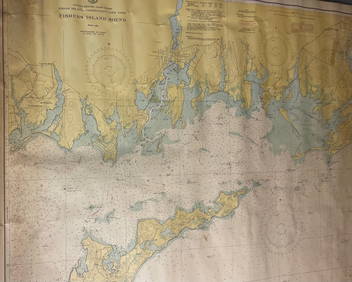
CHART: UNITED STATES - EAST COAST/ RHODE ISLAND - CONNECTICUT - NEW YORK/ Fishers IslandChurchill Galleries3.7(217)See Sold PriceFeb 26, 2024
CHART: UNITED STATES - EAST COAST MASSACHUSETTS/ HYANNIS HARBORAND VICINITYChurchill Galleries3.7(217)See Sold PriceFeb 26, 2024
Chart: United States- East Coast/ NORTH CAROLINA/ RIVER INLET TO CAPE FEAR.Churchill Galleries3.7(217)See Sold PriceFeb 26, 2024
CHART: UNITED STATES - EAST COAST NEW YORK/ HUDSON RIVER/ POUGHKEEPSIE TO HUDSONChurchill Galleries3.7(217)See Sold PriceFeb 26, 2024