17TH C. ENGLISH LINEAR MAP BY OGILBY, FRAMEDThomaston Place Auction Galleries4.4(389)See Sold PriceFeb 24, 2024
MAP - PIETER SCHENK / VALK / JANSSEN Hand Colored superb Map Central Italy c1702Luis Porretta Fine Arts4.3(10)See Sold PriceMar 02, 2024
OGILVY & BOWEN c1736 Original Map of Oxfordshire Berkshire Etc.Luis Porretta Fine Arts4.3(10)See Sold PriceMar 02, 2024
CHARLES ROLLIN c1828 Ceasar Hand Colored Africa Military MapLuis Porretta Fine Arts4.3(10)See Sold PriceMar 02, 2024
MAP - Dufour, A. H. ( Malte / Brun ) :MAP - ESPAGNE PARTIE SUD DIVISEE EN PROVINCES ANCIENNES ( MAPLuis Porretta Fine Arts4.3(10)See Sold PriceMar 02, 2024
RIGOBERT BONNE c1787 Original Colored Map Germany & Region 15" x 12"Luis Porretta Fine Arts4.3(10)See Sold PriceMar 02, 2024
AMBROISE TARDIEU c1822 Napoleonic War Map GermanyLuis Porretta Fine Arts4.3(10)See Sold PriceMar 02, 2024
MAP - AMBROISE TARDIEU c1822 Napoleonic Miltary Map GermanyLuis Porretta Fine Arts4.3(10)See Sold PriceMar 02, 2024
1822 Rare Map by Ambroise Tardieu Napoleon Caldiero Battle of Vento 17" x 11Luis Porretta Fine Arts4.3(10)See Sold PriceMar 02, 2024
THOMAS MOULE 1837 Colored Map of Warwickshire Framed vgcLuis Porretta Fine Arts4.3(10)See Sold PriceMar 02, 2024
PIETER SCHENK / VALK / JANSSEN Hand Colored Map of Rhodes Greece ca1702 vgcLuis Porretta Fine Arts4.3(10)See Sold PriceMar 02, 2024
STICH & DRUCK c1888 Map Austrian Alps 20" x 16"Luis Porretta Fine Arts4.3(10)See Sold PriceMar 02, 2024
Bellin: Antique Map of New Zembla, Russian Island, 1750Map: New Zembla Northern Russian Island Date Printed: 1750's-60's Cartographer: Jacques Nicholas Bellin Material/Medium: Paper Size: 9 1/2 " x 7 1/4 ' Condition: Excellent. The margins have been trimmSee Sold Price
SoldBellin: Antique Map of New Zembla Island, 1750Title/Content of Map: Island of New Zembla Northern Russia Arctic Ocean Date Printed: 1750's -60's Cartographer: Jacques Nicolas Bellin Material/Medium: Paper Size: 9 1/2" x 7" Copperplate engraving.See Sold Price
Bellin: Antique Map of New Zembla Island, Russia, 1740Title/Content of Map: New Zembla Island, Russia, North of Siberia Date Printed: c1740-70's Cartographer: J.N. Bellin & J.F. La Harpe Material/Medium: Paper Size: 15" x 10" Copperplate engraved. PublisSee Sold Price
Bellin: Antique Map of Kuril Islands, Russia, 1750Carte des Isles Kouriles A strong, dark impression of Bellin's finely engraved map of the Kurile Islands, the volcanic island chain extending from Russia's Kamchatka Peninsula to Hokkaido Island ("Is.See Sold Price
Bellin: Antique Map of New Zembla, 1740Title/Content of Map: New Zembla by Bellin Date Printed: c1740-70's Cartographer: J.N. Bellin & J.F. La Harpe Material/Medium: Paper Size: 15" x 9 1/2" Published in Paris. Copperplate engraved. From tSee Sold Price
Bellin: Antique Map of New Zembla, 1740-70Title/Content of Map: New Zembla by Bellin Date Printed: 1740-70's Cartographer: J.N. Bellin& J.F. La Harpe Material/Medium: Paper Size: 15" x 9 1/2: Copperplate engraved. Published in Paris. From theSee Sold Price
SoldBellin: Antique Map of Island of Ceylon, 1750Map: Carte de l'Isle de Ceylan Cartographer: Bellin Place & Date: Paris / 1750/1760 Size: 10" x 9 1/2" Condition: b&w; light overall age toning; old folds; small stain in lower margin; margins extendeSee Sold Price
SoldBellin: Antique Map of Kouriles Islands (Japan), 1750Map: Kouriles Islands (North of Japan) Date Printed: 1750-60's Cartographer: Jacques Nicolas Bellin Material/Medium: Paper Size: 14 1/2" x 10 3/4" Condition: Good. Some foxing on edges, and one brownSee Sold Price
Bellin: Antique Maps of the Moluccan Islands, 1750Map: Carte des Isles voisines des Moluques Ceram, Bouro, Amboine, Banda, Neyra etc [and] Carte Particuliere de l'Isle d'Amboine [and] Isle de Banda Cartographer: Bellin Place & Date: Paris / 1750/1760See Sold Price
Bellin: Antique Map of the Canary Islands, 1750Map: Canary Islands Date Printed: 1750 Cartographer: Nicholas Bellin Material/Medium: Paper Size: 12 1/2" x 10" Condition: Excellent Printed in Paris. Copperplate engraving. L'Histoire Generale Les VoSee Sold Price
Bellin: Antique Map of Island of Mombasa Kenya, 1750Title/Content of Map: 'Carte de L'Isle de Monbasa' Mombasa, Kenya Date Printed: c1750 Image Size: Approx 22.0 x 17.0cm, 8.75 x 6.75 inches (Medium); Please note that this is a folding map . Type: OrigSee Sold Price
Antique Map of New Zembla by BellinTitle/Content of Map: New Zembla by Bellin Date Printed: 1740-70's Cartographer: J.N. Bellin & J.F. La Harpe Material/Medium: Paper Size: 15" x 10" Provenance: New York From the 'Abrege de L'HistoireSee Sold Price
Antique Map of New Zembla by BellinTitle/Content of Map: New Zembla by Bellin Date Printed: 1740-70's Cartographer: J.N. Bellin & J.F. La Harpe Material/Medium: Paper Size: 15" x 9 1/2" Provenance: New York Copperplate engraved. PublisSee Sold Price
SoldBellin: Antique Map of Straights off New Zemble, 1740Title/Content of Map: Straights off New Zemble on the Arctic Ocean off of Russia Date Printed: 1740-70's Cartographer: J.N. Bellin & J.F. La Harpe Material/Medium: Paper Size: 14 1/2" x 10" CopperplatSee Sold Price
Bellin: Antique Map of Eastern Siberia, 1740Title/Content of Map: Eastern Siberia off Sakhalin Island Date Printed: 1740-70's Cartographer: J.N. Bellin & J.F. La Harpe Material/Medium: Paper Size: 15" x 9 3/4" Copperplate engraved. Published inSee Sold Price
SoldBellin: Antique Map of Eastern Siberia, 1750Map: Eastern Siberia Date Printed: 1750-60's Cartographer: Jacques Nicolas Bellin Material/Medium: Paper Size: 14" x 11" Condition: Excellent Copperplate engraving. Double page Map. From the Atlas DeSee Sold Price
Bellin: Antique Map of Manchuria & Siberia, 1750Map: Manchuria into eastern most Siberia Date Printed: 1750-60's Cartographer: Jacques Nicolas Bellin Material/Medium: Paper Size: 13 3/4" x 10 1/2" Condition: Excellent Copperplate engraving. DoubleSee Sold Price
SoldBellin: Antique Map of the Kamchatka Peninsula, 1758Title/Content of Map: Carte du Kamtchatka Dressée et Gravée par Laurent' A map of the Kamchatka Peninsula and the northern Kurile Islands Date Printed: 1758 Image Size: Approx 55.0 x 32.5cm, 21.5 xSee Sold Price
Bellin: Antique Map of Kamchatka, Russia, 1758TITLE OF THE MAP: 'Carte du Kamtchatka Dressée et Gravée par Laurent' A map of the Russian Far East peninsula of Kamchatka, and the northern Kurile islands DATE PRINTED: 1758 IMAGE SIZE: Approx 52.5See Sold Price
SoldWeller: Antique Map of Empire of Japan, 1863TITLE/CONTENT OF MAP: 'The Empire of Japan with part of the Continent of Asia showing The River Amoor and the New Boundary between The Russian & Chinese Territories' The map shows the Island of SakhalSee Sold Price
SoldGroup of 9 MapsLot of nine antique maps. 1746 Bellin map of Cape Verde island. H 10" W 14". 1574 Sebastion Munster map from 'Cosmographia Universalis'. H 12-5/8" W 7-1/8". 1598 Sebastion Munster map of Ireland, ScotSee Sold Price
SoldTwelve Antique French Maps by BellinTwelve Antique French Maps by Bellin , 1750-1767, most sheets 25 in. x 36 in Provenance: Property deaccessioned from the Louisiana State Museum, proceeds to be used for new acquisitions or the directSee Sold Price
Vaugondy: Antique Map of the East Indies, 1750The maps covers the East Indies including Borneo, Java, Sumatra, Celebes/Sulawesi, the lesser Sunda Islands and the Moluccas, the Philippines, part of New Guinea, The Malay peninsula and much of the eSee Sold Price
SoldNorthern Siberia & New ZemblaNorthern Siberia & New Zembla 1740-70's J.N. Bellin & J.F. La Harpe 11 1/2" x 10" Copperplate engraved. Published in Paris. From the 'Aberge de L'Histoire Generale des Voyages' Please note that this lSee Sold Price
Group of Ten Railroad Photographs, Maps, and Prints - New Jersey, Long Island, and New YorkRail & Road Auctions4.6(165)See Sold PriceMar 07, 2024
1750 Bowen Map of Bermuda and St. Kitts -- A New & Accurate Map of Bermudas or Sommer's Islands...Jasper524.5(9.8k)See Sold PriceFeb 27, 2024
Coste Occidentale d’Afrique…' West Africa. Gulf of Guinea. BELLIN 1746 mapJasper524.5(9.8k)See Sold PriceFeb 28, 2024
Plan de la Baye & Isle d'Arguim'. Mauritania. Arguin island. BELLIN 1746 mapJasper524.5(9.8k)See Sold PriceFeb 28, 2024
Coste d’Afrique…' Guinea-Bissau & Bissagos archipelago. BELLIN 1746 old mapJasper524.5(9.8k)See Sold PriceFeb 28, 2024
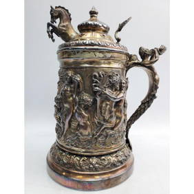
"Sazikov" Antique Russian Silver Large SteinWorld Auction Gallery LLC4.7(264)See Sold PriceMar 10, 2024
4 Judaica Antique Russian Silver Torah PointersWorld Auction Gallery LLC4.7(264)See Sold PriceMar 10, 2024
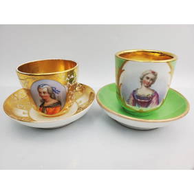
2 Antique Russian Porcelain Large Cups & SaucersWorld Auction Gallery LLC4.7(264)See Sold PriceMar 10, 2024
Jacques Nicolas Bellin - Antique Map - Vue de la Rade de Tiniam, double antique coast view of theProverde Auctions4.3(3)See Sold PriceFeb 28, 2024
Antique Pennsylvania Map Fragment incl Wellersburg and New CentervilleCordier Auctions4.4(1.5k)See Sold PriceMar 02, 2024