17TH C. ENGLISH LINEAR MAP BY OGILBY, FRAMEDThomaston Place Auction Galleries4.4(386)See Sold PriceFeb 24, 2024
MAP - PIETER SCHENK / VALK / JANSSEN Hand Colored superb Map Central Italy c1702Luis Porretta Fine Arts4.3(10)See Sold PriceMar 02, 2024
OGILVY & BOWEN c1736 Original Map of Oxfordshire Berkshire Etc.Luis Porretta Fine Arts4.3(10)See Sold PriceMar 02, 2024
CHARLES ROLLIN c1828 Ceasar Hand Colored Africa Military MapLuis Porretta Fine Arts4.3(10)See Sold PriceMar 02, 2024
MAP - Dufour, A. H. ( Malte / Brun ) :MAP - ESPAGNE PARTIE SUD DIVISEE EN PROVINCES ANCIENNES ( MAPLuis Porretta Fine Arts4.3(10)See Sold PriceMar 02, 2024
RIGOBERT BONNE c1787 Original Colored Map Germany & Region 15" x 12"Luis Porretta Fine Arts4.3(10)See Sold PriceMar 02, 2024
AMBROISE TARDIEU c1822 Napoleonic War Map GermanyLuis Porretta Fine Arts4.3(10)See Sold PriceMar 02, 2024
MAP - AMBROISE TARDIEU c1822 Napoleonic Miltary Map GermanyLuis Porretta Fine Arts4.3(10)See Sold PriceMar 02, 2024
1822 Rare Map by Ambroise Tardieu Napoleon Caldiero Battle of Vento 17" x 11Luis Porretta Fine Arts4.3(10)See Sold PriceMar 02, 2024
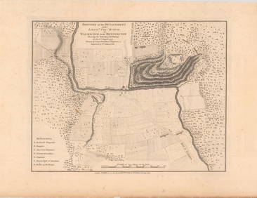
THOMAS MOULE 1837 Colored Map of Warwickshire Framed vgcLuis Porretta Fine Arts4.3(10)See Sold PriceMar 02, 2024
PIETER SCHENK / VALK / JANSSEN Hand Colored Map of Rhodes Greece ca1702 vgcLuis Porretta Fine Arts4.3(10)See Sold PriceMar 02, 2024
STICH & DRUCK c1888 Map Austrian Alps 20" x 16"Luis Porretta Fine Arts4.3(10)See Sold PriceMar 02, 2024
Homann Heirs: Antique Battle Plan of Prague, 1743Title: Kriegs-Expeditions-Karte in Bohmen I. Blat, in welchem die Haubtstadt Prag mid der Franzossischen und Saechsischen Belagerug und Eroberung So Den 26 November 1741... Map maker: Homann Heirs PlaSee Sold Price
SoldHomann Heirs: Antique Plan of Havana and Harbor, 1739Neu und verbesserte Plan der St. u. Hafens Havana A superbly detailed bird's-eye plan of Havana and its harbor, with depth soundings, a numbered key to principal sites, a magnificent martial-motif titSee Sold Price
SoldUNFRAMED ANTIQUE MAP OF ASIA MINOR , HOMANN HEIRS, 1743"Carte de L'Asie Minevre ou de la Natolie et du Pont Evxin Tiree des Voyages et des Observations de Anciens et Modernes,...Heretiers de Homann. Nuremb.". Hand colored copperplate engraving. Unframed,See Sold Price
SoldPlan of Battle at Prague in 1741Heading: Author: Homann Heirs Title: Kriegs-Expeditions-Karte in Bohmen I. Blat, in welchem die Haubtstadt Prag mid der Franzossischen und Saechsischen Belagerug und Eroberung So Den 26 November 1741See Sold Price
Plan of Battle at Prague in 1741Heading: Author: Homann Heirs Title: Kriegs-Expeditions-Karte in Bohmen I. Blat, in welchem die Haubtstadt Prag mid der Franzossischen und Saechsischen Belagerug und Eroberung So Den 26 November 1741See Sold Price
UNFRAMED ANTIQUE MAP OF ASIA MINOR , HOMANN HEIRS, 1743"Carte de L'Asie Minevre ou de la Natolie et du Pont Evxin Tiree des Voyages et des Observations de Anciens et Modernes,...Heretiers de Homann. Nuremb.". Hand colored copperplate engraving. Unframed,See Sold Price
Plan of Battle at Prague in 1741Heading: Author: Homann Heirs Title: Kriegs-Expeditions-Karte in Bohmen I. Blat, in welchem die Haubtstadt Prag mid der Franzossischen und Saechsischen Belagerug und Eroberung So Den 26 November 1741See Sold Price
SoldHomann Heirs: Antique Revolutionary War Map of the USTitle: 1777 Revolutionary War issue of Homann's map of the United States. America Septentrionalis a Domino d'Anville in Galliis edita nunc in Anglia Coloniis in Interiorem Virginiam... Map maker: HomaSee Sold Price
SoldHomann Heirs: Antique Composite Map of West Indies 1740Map: Mappa Geographicae, complectens Indiae Occidentalis/ Carte des Isles de l'Amerique Cartographer: Homann Heirs/J.B.B. d'Anville Place & Date: Nurnberg / 1740 Size: 19" x 22 5/8" Condition: Main WeSee Sold Price
SoldHomann Heirs: Antique Map of North & South America 1746Title/Content of Map: Americae mappa generalis Date Printed: 1746 Cartographer: Homann Heirs Material/Medium: Paper Size: 23 1/2" x 21" Hand colored copperplate engraved. Published in Nuremberg. Map hSee Sold Price
Homann Heirs: Antique Map of the World, 1720Map: World Date Printed: 1720 Cartographer: Homann Heirs Material/Medium: Paper Size: 21" x 24" Double page on thick paper. One of the most decorative world maps of the 1700's. J.B. Homann is one of tSee Sold Price
Homann Heirs: Antique Celestial Chart, 1740Map: Celestial Chart Date Printed: c 1740's Cartographer: Homann Heirs Material/Medium: Paper Size: ***Approx 22" x 25" Published in Nuremberg. Thick paper. Hand colored copperplate engraved. Based onSee Sold Price
SoldHomann Heirs: Antique Map of Asia, 1746Map: Asia Date Printed: 1746 Cartographer: Homann Heirs Material/Medium: Paper Size: 23 3/4" x 21" Printed in Nuremberg. Hand colored copperplate engraved. Beautiful baroque style cartouche. Please noSee Sold Price
Homann Heirs: Antique Map of the World, 1746Map: World Date Printed: 1746 Cartographer: Homann Heirs Material/Medium: Paper Size: 23 3/4" x 21" Printed in Nuremberg. Thick paper. Features the world in double hemispheres. Two projections show poSee Sold Price
Homann Heirs: Antique Map of World in Hemispheres, 1746Map: Planiglobi Terrestris Mappe Monde Date Printed: 1746 Cartographer: Homann Heirs Material/Medium: Paper Size: 23" x 21 1/3" Condition: Excellent The World in double Hemispheres. Two proejctions shSee Sold Price
SoldHomann Heirs: Antique Map of Corsica, 1732Map: Insulae Corsicae olim Cyrus dictae Cartographer: Homann Heirs Place & Date: Nuremberg / 1732 Size: 17" x 20 3/8" Condition: overall age toning, heavier along horizontal centerfold; some light watSee Sold Price
SoldHomann Heirs: Antique Map of Europe, 1746Map: Europe ** Nuremberg?? Date Printed: 1746 Cartographer: Homann Heirs Material/Medium: Paper Size: 21" x 23 1/4" Nuremberg. Hand colored copperplate engraved. Beautiful baroque style cartouche. PleSee Sold Price
SoldHomann Heirs: Antique Map of British West Indies, 1740Map: Dominia Anglorum in praecipuis Insulis Americae Cartographer: Homann Heirs Place & Date: Nuremberg / 1740 Size: 22" x 19 1/4" Condition: outline color; overall age toning; repaired splits at centSee Sold Price
Homann Heirs: Antique Maps of British Colonies, 1745Map: Dominia Anglorum in America Septentrionali Subtitle: Dominia Anglorum in America Septentrionali Specialibus Mappis Londini primum a Mollio edita nune recusa ab Homannianis Hered. Creator: HomannSee Sold Price
Homann Heirs: Antique Map of Italia, 1742Title/Content of Map: Italia Date Printed: 1742 Size (inches): 21 x 19 Condition: Good. Colorful on strong chain-laid paper with watermark. Repaired area at bottom right outside neatline, except for lSee Sold Price
Homann Heirs: Antique Map of Great Tartary, 1739Map: Tartariae. Maioris five Asiaticae tabvla Publication Date: 1739 Cartographer: Johann Matthias Haas (1684-1742) Publisher: Homann heirs 1739 Nuremberg Size: Double Folio – 18.75 H x 21.5 W IncheSee Sold Price
Homann Heirs: Antique Map of Hungary & Balkans, 1750Title/Content of Map: Hvngariae Ampliori Significatu... Carte D'hongrie En General..." Date Printed: 1750 ca. Cartographer: HOMANN HEIRS Publisher/Place: HOMANN HEIRS 1750 ca. NUREMBERG Size: Folio ��See Sold Price
Homann Heirs: Antique Map of Hungary, 1750Map: Hvngariae Ampliori Significatu... Carte D'hongrie En General..." Publication Date: 1750 ca. Authors: HOMANN HEIRS, HOMANN HEIRS Publisher: HOMANN HEIRS Size: Folio – 18.30 H x 23.10 W Inches DeSee Sold Price
SoldJohn Baptist Homann Heirs, "Plan und Prospect von derJohn Baptist Homann Heirs, "Plan und Prospect von der stadt, Vestung, Bay und Fortifications von Gibraltar," 1733, H. - 20 in., W. - 23 in.See Sold Price
Antique Neoclassical Inlaid Carved Wood DresserThe Benefit Shop Foundation Inc.4.3(2.9k)See Sold PriceMar 06, 2024
1736 LARGE MAP OF SILESIA POLAND OPPAVIENSIS antique 25 by 34 3/4"Jasper524.5(9.8k)See Sold PriceFeb 27, 2024
1736 LARGE MAP OF SILESIA POLAND KARNOVIENSIS antique 25 x 4 3/4" Duchy of KrnovJasper524.5(9.8k)See Sold PriceFeb 27, 2024
AFRICA. Pre 'Scramble for Africa'. BARTHOLOMEW 1876 old antique map plan chartJasper524.5(9.8k)See Sold PriceFeb 28, 2024
AFRICA. French North Africa and Morocco 1907 old antique map plan chartJasper524.5(9.8k)See Sold PriceFeb 28, 2024
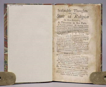
ANTIQUE AMERICANA, 1743: SEASONABLE THOUGHTS ON THE STATE OF RELIGION IN NEW ENGLANDNY Elizabeth 4.3(84)See Sold PriceMar 03, 2024
T. Kelly - Plan of Bruseels - Battle of Waterloo, London - History of the French RevolutionProverde Auctions4.3(3)See Sold PriceFeb 28, 2024
Antique English Victorian Style Bamboo Mirror StandThe Benefit Shop Foundation Inc.4.3(2.9k)See Sold PriceMar 20, 2024
Pr Antique Louis XVI Caned Back Chairs W/ CushionsThe Benefit Shop Foundation Inc.4.3(2.9k)See Sold PriceMar 20, 2024
Pair Antique Japanese Imari Porcelain PlatesThe Benefit Shop Foundation Inc.4.3(2.9k)See Sold PriceMar 20, 2024