MATTHEWS c1856 Map Of Upper Canada Ontario Indian Land Agency Divisions Scarce!Luis Porretta Fine Arts4.3(10)See Sold PriceMar 02, 2024
DEVINE c1856 Dr Salters Map Of Lake Huron Ontario Indian Lands etc. No. 7 ScarceLuis Porretta Fine Arts4.3(10)See Sold PriceMar 02, 2024
DUNLEVIE c1856 Map Counties Of Gaspe & Bonaventure Quebec Canada SCARCE! #1Luis Porretta Fine Arts4.3(10)See Sold PriceMar 02, 2024
DUNLEVIE c1856 Map Counties Of Gaspe & Bonaventure Quebec Canada SCARCE! #2Luis Porretta Fine Arts4.3(10)See Sold PriceMar 02, 2024
Map UNITED COUNTIES LEEDS & GRENVILLE by Walling 1861 Rare Canada Map 5ft x 5ftLuis Porretta Fine Arts4.3(10)See Sold PriceMar 02, 2024
Ambroise TARDIEU c1822 Map Venice Napoleon Italian Campaign 17" x 11"Luis Porretta Fine Arts4.3(10)See Sold PriceMar 02, 2024
SoldBuache: Antique Map of New York, Long Island, 1807Map: Ile de New-York Partie de Long-Island ou de l'Ile Longue et positions des armées Américaine et Britannique après le combat livré sur les hauteurs, le 27 Août, 1776. Maker: Buache, Jean NicolSee Sold Price
Antique Map Shows New York City in 1776, Marshall, 1807Antique Map Showing New York City in 1776 -- Ile de New-York. Partie de Long-Island ou de l'Ile Longue, et Positions des Armees Americaine et Britannique, apres le Combat Livre sur Hauteurs, le 27 AouSee Sold Price
Marshall: Antique Map Showing New York City in 1776Map: 1807 Marshall Map Showing New York City in 1776 -- Ile de New-York. Partie de Long-Island ou de l'Ile Longue, et Positions des Armees Americaine et Britannique, apres le Combat Livre sur HauteursSee Sold Price
Marshall: Antique Map Showing New York City in 1776Map: 1807 Marshall Map Showing New York City in 1776 -- Ile de New-York. Partie de Long-Island ou de l'Ile Longue, et Positions des Armees Americaine et Britannique, apres le Combat Livre sur HauteursSee Sold Price
Marshall: Antique Map Showing New York City in 1776Title/Content of Map: 1807 Marshall Map Showing New York City in 1776 -- Ile de New-York. Partie de Long-Island ou de l'Ile Longue, et Positions des Armees Americaine et Britannique, apres le Combat LSee Sold Price
Marshall: Antique Map Showing New York City in 1776Title/Content of Map: 1807 Marshall Map Showing New York City in 1776 -- Ile de New-York. Partie de Long-Island ou de l'Ile Longue, et Positions des Armees Americaine et Britannique, apres le Combat LSee Sold Price
Marshall: Antique Map Showing New York City in 1776Title/Content of Map: 1807 Marshall Map Showing New York City in 1776 -- Ile de New-York. Partie de Long-Island ou de l'Ile Longue, et Positions des Armees Americaine et Britannique, apres le Combat LSee Sold Price
SoldLot 8 Framed Vintage Maps. New York. Some Long IsLot 8 Framed Vintage Maps. New York. Some Long Island. Towns of Brookhaven: Suffolk County. Bath; New Utrecht; Brooklyn. Southhampton. Bellport. Southold; Mattituck. Greenport. Setauket. Bay Shore. NeSee Sold Price
SoldLot 4 Framed Vintage Maps. New York. Jamaica. HemLot 4 Framed Vintage Maps. New York. Jamaica. Hempstead. Oyster Bay, Long Island. Huntington. Tiger Maple Frame. -- Dimensions: Image Size: H: 14.5 inches: W: 31.5 inches ---See Sold Price
New York & Long Island Wall Map, 1901New York and vicinity wall map by Rand McNally, 1901. Displayed in a wood frame and ultra clear plexiglass. Dimensions: 46" L x 52" W x 1.5" HSee Sold Price
SoldGroup of 21 Antique Service Station Road MapsCirca 1920s-30s, Includes New York, New Jersey, Long Island, Amoco, Gulf, Shell, Pan-Am, and MoreSee Sold Price
Fire Island & Oak Island, New York, 1902Fire Island & Oak Island, Long Island, New York. Map features Point O'Woods Association, Oak Island in Babylon & Coolier Channel. Original engraving published by E. Belcher Hyde from "Atlas of SuffolkSee Sold Price
SoldVintage map of Long Island New YorkVintage map of Long Island.Good condition,matted and framed. Size 30 1/4 x 34 1/4 inches. Condition goodSee Sold Price
Homann: Antique Map of New England, 1720Nova Anglia'.New England Novum Belgium.Long Island Jorck Shire. The map names New England as "Almouchi Cosen" as well as Nova Anglia, while present-day New York State is named variously as New Jork, NSee Sold Price
Fire Island & Oak Island Beach, 1902Map of part of Fire Island and Oak Island Beach. Original engraving published by E. Belcher Hyde from "Atlas of Suffolk County, Long Island, New York," Philadelphia, 1902. Map highlights family names,See Sold Price
Sold1807 Marshall Map Showing New York City in 1776 -- IleTitle/Content of Map: 1807 Marshall Map Showing New York City in 1776 -- Ile de New-York. Partie de Long-Island ou de l'Ile Longue, et Positions des Armees Americaine et Britannique, apres le Combat LSee Sold Price
Southampton Map, 1902Southampton: Cooper's Neck, Halsey Neck, Captain's Neck & Taylor's Creek. Original engraving published by E. Belcher Hyde from "Atlas of Suffolk County, Long Island, New York," Philadelphia, 1902. MapSee Sold Price
Southampton Map (Agawam Lake), 1902Original engraving of Southhampton, including Agawam Lake, Old Town Pond, many landmarks and family names. Published by E. Belcher Hyde from "Atlas of Suffolk County, Long Island, New York," 1902. DimSee Sold Price
1807 Map NY Island Rev. War Plan C.P. WayneA Plan of New York Island and part of Long Island. Showing the Position of the American and British Armies, before, at, and after the Engagement on the Heights, August 27th, 1776, from a ten map atlasSee Sold Price
Sold3 Maps including New York, Long Island, CT & RILot includes: Plan of New York & part of Long Island... American & British Armies…on the Heights engraved by J Yeager (Frame: 16" x 12" image sight: 9.75" x 7"), A New & Accurate Map of ConnecticutSee Sold Price
Map of New York & Long Island, 1868Original engraving from Johnson's Atlas of the World, 1868. Map includes vignette of Long Island & cities, towns and territories. Dimensions: 18" x 26". No Reserve This item ships from Ocean View, DE.See Sold Price
Map of New York & Long Island, 1868Original engraving from Johnson's Atlas of the World, 1868. Map includes vignette of Long Island & cities, towns and territories. Dimensions: 18" x 26". Shipping Domestic: Shipping rates are determindSee Sold Price
Map of New York & Long Island, 1868Original engraving from Johnson's Atlas of the World, 1868. Map includes vignette of Long Island & cities, towns and territories. Dimensions: 18" x 26". No Reserve Buyer pays shipping - ships from OceSee Sold Price
Map of New York & Long Island, 1868Original engraving from Johnson's Atlas of the World, 1868. Map includes vignette of Long Island & cities, towns and territories. Dimensions: 18" x 26". This item ships from Ocean View, DE.See Sold Price
Bernard Karfiol (NY,NJ,Hungary,1886-1952) oil paintingBroward Auction Gallery4.7(292)See Sold PriceMar 31, 2024
Group of Ten Railroad Photographs, Maps, and Prints - New Jersey, Long Island, and New YorkRail & Road Auctions4.6(165)See Sold PriceMar 07, 2024
Charles Fazzino, "There's Music: New Jersey, New York, Long Island Too!!" Framed 3D Limited EditionRobinhood Auctions4.7(794)See Sold PriceFeb 29, 2024
1800's Antique Postcard Manuscript of Home Sweet Home HEstate Collection Auctioneer4(119)See Sold PriceMar 02, 2024
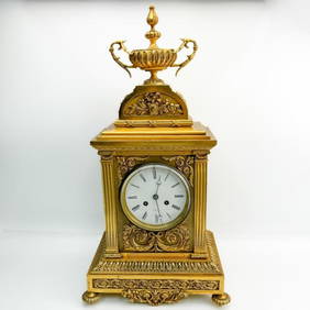
Antique Tiffany & Co NY Dore Bronze Mantel ClockWorld Auction Gallery LLC4.7(264)See Sold PriceMar 10, 2024
Antique 3 Piece Tiffany & Co. New York Clock SetWorld Auction Gallery LLC4.7(264)See Sold PriceMar 10, 2024
Antique Chinese Photo of Government MinisterAffinity Antique Auction4.6(251)See Sold PriceMar 03, 2024
2020 1oz Silver Treasures of the U.S.California GoAffinity Antique Auction4.6(251)See Sold PriceMar 03, 2024
19th.C Chinese Famille Rose Porcelain Fruit Tray,Affinity Antique Auction4.6(251)See Sold PriceMar 03, 2024
Three Chinese Jade Carved Plaque,Beast and DragonAffinity Antique Auction4.6(251)See Sold PriceMar 03, 2024