MATTHEWS c1856 Map Of Upper Canada Ontario Indian Land Agency Divisions Scarce!Luis Porretta Fine Arts4.3(10)See Sold PriceMar 02, 2024
DEVINE c1856 Dr Salters Map Of Lake Huron Ontario Indian Lands etc. No. 7 ScarceLuis Porretta Fine Arts4.3(10)See Sold PriceMar 02, 2024
DUNLEVIE c1856 Map Counties Of Gaspe & Bonaventure Quebec Canada SCARCE! #1Luis Porretta Fine Arts4.3(10)See Sold PriceMar 02, 2024
DUNLEVIE c1856 Map Counties Of Gaspe & Bonaventure Quebec Canada SCARCE! #2Luis Porretta Fine Arts4.3(10)See Sold PriceMar 02, 2024
Map UNITED COUNTIES LEEDS & GRENVILLE by Walling 1861 Rare Canada Map 5ft x 5ftLuis Porretta Fine Arts4.3(10)See Sold PriceMar 02, 2024
Ambroise TARDIEU c1822 Map Venice Napoleon Italian Campaign 17" x 11"Luis Porretta Fine Arts4.3(10)See Sold PriceMar 02, 2024
Antique Map of California & Nevada, 1876[California, Nevada]. N.p: Hardesty & Co, 1876. Coloured map. Approximately 19-3/4 x 14-1/4 inches, one sheet. Verso is printed with a map and legend of Liberty Township. Please note that this lot hasSee Sold Price
Bancroft's Map of California, Nevada, 1876Heading: Author: Bancroft, Albert Little Title: Bancroft's Map of California, Nevada, Utah and Arizona, Published by A. L. Bancroft & Compy. Booksellers & Stationers San Francisco Cal. 1876 Place PubSee Sold Price
SoldBancroft's Map of California, Nevada, 1876Heading: Author: Bancroft, Albert Little Title: Bancroft's Map of California, Nevada, Utah and Arizona, Published by A. L. Bancroft & Compy. Booksellers & Stationers San Francisco Cal. 1876 Place PubSee Sold Price
SoldBancroft's Map of California, Nevada, 1876Heading: Author: Bancroft, Albert Little Title: Bancroft's Map of California, Nevada, Utah and Arizona, Published by A. L. Bancroft & Compy. Booksellers & Stationers San Francisco Cal. 1876 Place PubSee Sold Price
Gray: Antique Map of California & Nevada, 1875Map: 1875 Gray's Map of California and Nevada - Gray's Atlas California and Nevada Date Printed: 1875, Philadelphia Cartographer: F Gray Size: 26.4 X 15.4 in. Condition: Excellent. Very slight age tonSee Sold Price
Gray's Antique Map of California and Nevada, 1875Title/Content of Map: 1875 Gray's Map of California and Nevada - Gray's Atlas California and Nevada Date Printed: 1875, Philadelphia Cartographer: F Gray Size: 26.4 X 15.4 in. Very nice large size mapSee Sold Price
Hardesty & Co: Map of California and Nevada, 1876[CALIFORNIA, NEVADA]. Map of California and Nevada. N.p : Hardesty & Co, 1876. Coloured map. Approximately 19-3/4 x 14-1/4 inches, one sheet. Verso is printed with a map and legend of Liberty TownshipSee Sold Price
Gray: Antique Map of California and Nevada, 1875Title/Content of Map: 1875 Gray's Map of California and Nevada - Gray's Atlas California and Nevada Date Printed: 1875, Philadelphia Cartographer: F Gray Size: 26.4 X 15.4 in. Very nice large size mapSee Sold Price
Sold[MAP]. GIBBES & Holt. California and Nevada. 1876.302. [MAP]. GIBBES, Charles Drayton (cartographer) & Warren Holt (publisher). Map of the States of California and Nevada...Entered According to Act of Congress in the Year 1876 by WarrSee Sold Price
SoldRand McNally: Antique Map of California, 1894Title/Content of Map: 1894 Rand McNally Map of California [verso] Nevada and Arizona -- Map of California [verso] Nevada; Arizona Date Printed: 1894, Chicago Cartographer: Rand McNally Size: 18.5 x 13See Sold Price
Johnson: Antique Map of California Territories, 18632-page Johnson’s 1863 Calif. Territories of N. Mexico Arizona Colorado Nevada & Utah. One of the most detailed accurate commercial maps of the era. One of the scarcest and most historically sigSee Sold Price
Rand McNally: Antique Map of California, 1894Title/Content of Map: 1894 Rand McNally Map of California [verso] Nevada and Arizona -- Map of California [verso] Nevada; Arizona Date Printed: 1894, Chicago Cartographer: Rand McNally Size: 18.5 x 13See Sold Price
SoldCalifornia Southwest Antique MapEarly map: California, also Utah, Nevada, Colorado, New Mexico and Arizona. Map by A.J. Johnson, New York, c. 1870. 18" x 26 1/2".See Sold Price
SoldScarce map of Calif./Nevada, Jones & HamiltonHand-colored map of California and Nevada from the very scarce Jones & Hamilton Historical Atlas of the World, published 1876 by Higgins Bros. & Co. Shows Indian tribes, railroads, topography, forts,See Sold Price
Sold4Pcs ANTIQUE AMERICAN MAPS County Map California4Pcs ANTIQUE AMERICAN MAPS County Map California Mitchel 1872 Color United States and Territories Canada Texas Indian Territory Mitchell 1876 Cram Carte du Continent de L′Amerique Nord E. CollinSee Sold Price
SoldJohnson's California Map w/ Territories - Utah,Johnson's California Map w/ Territories - Utah, Colorado, Nevada, etc....21" x 27 1/2"See Sold Price
SoldMap of western railroads 1876Title: Williams' New Trans-Continental Map of the Pacific R.R. and Routes of Overland Travel to Colorado, Nebraska, the Black Hills, Utah, Idaho, Nevada, Montana, California and the Pacific Coast AuthSee Sold Price
SoldDiderot/Vaugondy: Antique Map California & West AmericaTitle/Content of Map: Carte De La Californie Et Des Pays Nord Ouest separes de L'Asie par le Detroit d'Anian… Cartographer: Diderot/de Vaugondy Place & Date: Paris / 1772 Size: 14 3/8" x 11 7/8" ConSee Sold Price
SoldU S Coast Survey 1896 Map. California Nevada Boundary"Boundary Survey between California and Nevada. Sheet 1" Lithograph Map Published 1896, Washington for "U.S. Coast and Geodetic Survey" Folds as issued. Rare. Paper Size: 20 x 19.5 inch (50 x 49cm) GoSee Sold Price
SoldU S Coast Survey 1896 Map. California Nevada Boundary"Boundary Survey between California and Nevada. Sheet 1" Lithograph Map Published 1896, Washington for "U.S. Coast and Geodetic Survey" Folds as issued. Rare. Paper Size: 20 x 19.5 inch (50 x 49cm) VeSee Sold Price
U S Coast Survey 1896 Map. California Nevada Boundary"Boundary Survey between California and Nevada. Sheet 1" Lithograph Map Published 1896, Washington for "U.S. Coast and Geodetic Survey" Folds as issued. Rare. Paper Size: 20 x 19.5 inch (50 x 49cm) GoSee Sold Price
Sold3 Maps: CALIFORNIA & NEVADA + OREGON.[United States/West]. Asher & Adams. 3 Maps, lithographs in colors, each with center fold, few small spots, very good condition, slightly toned. ++ CALIFORNIA & NEVADA. NORTH PORTION. 1872. 16 ½ x 23See Sold Price
SoldWall map of California & NevadaHeading: (Wall Map - California & Nevada) Author: Title: Webers Township and County-Map of California, Nevada and Southern Oregon. Compiled and drawn from the latest data Place Published: San FrancisSee Sold Price
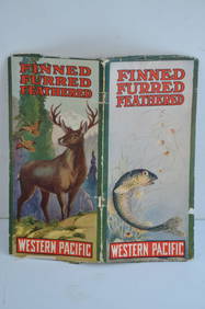
Western Pacific RR Finned Furred Feathered Brochure-1912JM Hobby Supply and Railroad Artifact Auctions4.4(126)See Sold PriceFeb 24, 2024
Strickler, Rare - San Francisco, CaliforniaTrillium Antique Prints & Rare Books4.5(30)See Sold PriceFeb 24, 2024
Morocco, Algeria, Tunisia & Libya. North Africa. HUGHES 1876 old antique mapJasper524.5(9.8k)See Sold PriceFeb 28, 2024
BRITISH AFRICAN COLONIES. West Africa Ascension St. Helena Mauritius 1876 mapJasper524.5(9.8k)See Sold PriceFeb 28, 2024
AFRICA. Pre 'Scramble for Africa'. BARTHOLOMEW 1876 old antique map plan chartJasper524.5(9.8k)See Sold PriceFeb 28, 2024
Francis McNally - Antique Map of California & MinnesotaProverde Auctions4.3(3)See Sold PriceFeb 28, 2024
Francis McNally - Antique Map of Washington, Oregon, Idaho, Nevada, Utah & ArizonaProverde Auctions4.3(3)See Sold PriceFeb 28, 2024
Colorful Illustrated Map - 1938 Southern California TourismProverde Auctions4.3(3)See Sold PriceFeb 28, 2024


![[MAP]. GIBBES & Holt. California and Nevada. 1876. (1 of 6)](https://p1.liveauctioneers.com/514/38482/16487208_1_x.jpg?height=282&quality=70&version=1363615005)