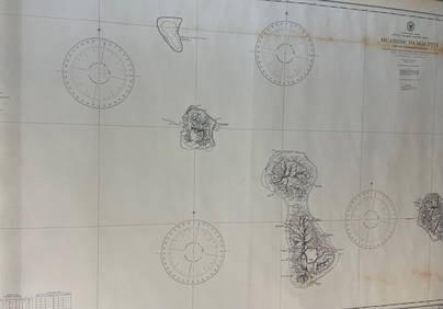
Sea Chart of Scandinavia Russia, Arctic Ocean, 1914Title/Content of Map: 'North European Ports; Inset Archangel'. Scandinavia Russia sea chart. Ports lighthouses. Arctic Ocean Bothnia Date Printed: c1914 Image Size: Approx 36.5 x 47.0cm, 14.5 x 18.5 iSee Sold Price
Scandinavia Russia sea chart. Ports lighthouses. Arctic Ocean Bothnia 1918 mapTITLE/CONTENT OF MAP: 'North European Ports; Inset Archangel' DATE PRINTED: 1918 IMAGE SIZE: Approx 36.5 x 47.0cm, 14.5 x 18.5 inches (Large) TYPE: Antique colour maritime map chart; Scale 1:200,000 CSee Sold Price
Scandinavia Russia sea chart. Ports lighthouses. Arctic Ocean Bothnia 1927 mapTITLE/CONTENT OF MAP: North European Ports [inset Svalbard (Spitsbergen); Göteborg; Bergen; Trondheim; Archangel] DATE PRINTED: 1927 IMAGE SIZE: Approx 36.5 x 47.0cm, 14.5 x 18.5 inches (Large);See Sold Price
Scandinavia Russia sea chart. Ports lighthouses. Arctic Ocean Bothnia 1952 mapTITLE/CONTENT OF MAP: 'North European Ports inset Svalbard (Spitsbergen); Narvik; Trondheim; Bergen; Oslo; Arkhangelsk; Copenhagen; The Sound' DATE PRINTED: 1952 IMAGE SIZE: Approx 36.5 x 47.0cm, 14.5See Sold Price
Scandinavia Russia sea chart. Ports lighthouses. Arctic Ocean Bothnia 1916 mapTITLE/CONTENT OF MAP: 'North European Ports; Inset Archangel' DATE PRINTED: 1916 IMAGE SIZE: Approx 36.5 x 47.0cm, 14.5 x 18.5 inches (Large) TYPE: Antique colour maritime map chart; Scale 1:200,000 CSee Sold Price
Scandinavia Russia sea chart. Ports lighthouses. Arctic Ocean Bothnia 1952 mapTITLE/CONTENT OF MAP: 'North European Ports inset Svalbard (Spitsbergen); Narvik; Trondheim; Bergen; Oslo; Arkhangelsk; Copenhagen; The Sound' DATE PRINTED: 1952 IMAGE SIZE: Approx 36.5 x 47.0cm, 14.5See Sold Price
Scandinavia Russia sea chart. Ports lighthouses. Arctic Ocean Bothnia 1959 mapTITLE/CONTENT OF MAP: 'North European Ports inset Svalbard (Spitsbergen); Narvik; Trondheim; Bergen; Oslo; Arkhangelsk; Copenhagen; The Sound' DATE PRINTED: 1959 IMAGE SIZE: Approx 36.5 x 47.0cm, 14.5See Sold Price
Scandinavia Russia sea chart. Ports lighthouses. Arctic Ocean Bothnia 1918 mapTITLE/CONTENT OF MAP: 'North European Ports; Inset Archangel' DATE PRINTED: 1918 IMAGE SIZE: Approx 36.5 x 47.0cm, 14.5 x 18.5 inches (Large) TYPE: Antique colour maritime map chart; Scale 1:200,000 CSee Sold Price
Scandinavia Russia sea chart. Ports lighthouses. Arctic Ocean Bothnia 1927 mapTITLE/CONTENT OF MAP: North European Ports [inset Svalbard (Spitsbergen); Göteborg; Bergen; Trondheim; Archangel] DATE PRINTED: 1927 IMAGE SIZE: Approx 36.5 x 47.0cm, 14.5 x 18.5 inches (Large);See Sold Price
Scandinavia Russia sea chart. Ports lighthouses. Arctic Ocean Bothnia 1916 mapTITLE/CONTENT OF MAP: 'Europe' DATE PRINTED: 1876 IMAGE SIZE: Approx 24.5 x 30.5cm, 9.75 x 12 inches (Large) TYPE: Antique hand coloured engraved map CONDITION: Good; suitable for framing. Please checSee Sold Price
Scandinavia Russia sea chart. Ports lighthouses. Arctic Ocean Bothnia 1959 mapTITLE/CONTENT OF MAP: 'North European Ports inset Svalbard (Spitsbergen); Narvik; Trondheim; Bergen; Oslo; Arkhangelsk; Copenhagen; The Sound' DATE PRINTED: 1959 IMAGE SIZE: Approx 36.5 x 47.0cm, 14.5See Sold Price
Scandinavia Russia sea chart. Ports lighthouses. ArcticTITLE/CONTENT OF MAP: 'North European Ports; Inset Archangel' DATE PRINTED: c1914 IMAGE SIZE: Approx 36.5 x 47.0cm, 14.5 x 18.5 inches (Large) TYPE: Antique colour maritime map chart; Scale 1:200,000See Sold Price
North Atlantic Ocean Sea Chart, 1914Title/Content of Map: 'The North Atlantic Ocean; Inset French Guinea; Nigeria'. North Atlantic Ocean sea chart. Ports lighthouses mail routes. This map is folding hence the centrefold line may show onSee Sold Price
South Atlantic Ocean Sea Chart, 1914Title/Content of Map: 'The South Atlantic Ocean; Inset Callao & Lima; Valparaiso; Rio de Janeiro; Cape Town; Rio de La Plata; Buenos Ayres; South African Ports; Port Natal' This map is folding hence tSee Sold Price
Antique Sea Chart Map of South Atlantic Ocean, 1914Title/Content of Map: 'The South Atlantic Ocean; Inset Callao & Lima; Valparaiso; Rio de Janeiro; Cape Town; Rio de La Plata; Buenos Ayres; South African Ports; Port Natal' South Atlantic Ocean sea chSee Sold Price
SoldPolar Regions Arctic/Antarctic Sea Chart, 1914Title/Content of Map: 'The Polar Regions; Arctic Regions; Antarctic Regions; Inset Greenland; Spitzbergen; The Bering Strait and Lower Yukon; Weddell Sea; Ross Sea' This map is folding hence the centrSee Sold Price
Sold19thc J. H. Colton Map of RussiaOriginal 19th Century map of Russia, from an 1857 edition of J. H. Colton's Atlas. pg 86, showing all regions, including the Black Sea, Caspian Sea & Arctic Ocean. 13 1/2" X 16 1/2". Good condition.See Sold Price
Sold19thc J. H. Colton Map of RussiaOriginal 19th Century map of Russia, from an 1857 edition of J. H. Colton's Atlas. pg 86, showing all regions, including the Black Sea, Caspian Sea & Arctic Ocean. 13 1/2" X 16 1/2". Good condition.See Sold Price
19thc J. H. Colton Map of RussiaOriginal 19th Century map of Russia, from an 1857 edition of J. H. Colton's Atlas. pg 86, showing all regions, including the Black Sea, Caspian Sea & Arctic Ocean. 13 1/2" X 16 1/2". Good condition.See Sold Price
19thc J. H. Colton Map of RussiaOriginal 19th Century map of Russia, from an 1857 edition of J. H. Colton's Atlas. pg 86, showing all regions, including the Black Sea, Caspian Sea & Arctic Ocean. 13 1/2" X 16 1/2". Good condition.See Sold Price
Sold19thc J. H. Colton Map of RussiaOriginal 19th Century map of Russia, from an 1857 edition of J. H. Colton's Atlas. pg 86, showing all regions, including the Black Sea, Caspian Sea & Arctic Ocean. 13 1/2" X 16 1/2". Good condition.See Sold Price
Sold19thc J. H. Colton Map of RussiaOriginal 19th Century map of Russia, from an 1857 edition of J. H. Colton's Atlas. pg 86, showing all regions, including the Black Sea, Caspian Sea & Arctic Ocean. 13 1/2" X 16 1/2". Good conditioSee Sold Price
EARLY 18TH C. DUTCH CHART OF PACIFIC OCEAN BY FREDERIK DE WIT (1629-1706) WITH CALIFORNIA AS ANThomaston Place Auction Galleries4.4(393)See Sold PriceFeb 24, 2024
Wooden Star Of India Tall Model Ship 30"Weatherham Estate Treasures3.9(159)See Sold PriceFeb 28, 2024
Linnea Pergola "Moonlight over Manhattan" Signed Seri. LEMichael's Gallery4.6(94)See Sold PriceFeb 24, 2024
Vintage brass ship door knocker nautical sea ocean decor pirate boat germanyJasper524.5(9.9k)See Sold PriceFeb 27, 2024
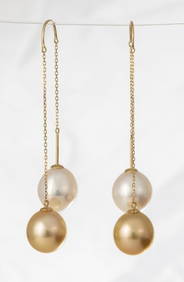
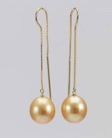
10x11mm Deep Golden South Sea Pearls - 18 kt. Yellow gold - EarringsJasper524.5(9.9k)See Sold PriceFeb 27, 2024
10x11mm Golden Australian South Sea Drops - 18 kt. Yellow gold - EarringsJasper524.5(9.9k)See Sold PriceFeb 27, 2024
West Indies Windward Lesser Antilles. Martinique (Belonging to France)Jasper524.5(9.9k)See Sold PriceFeb 27, 2024
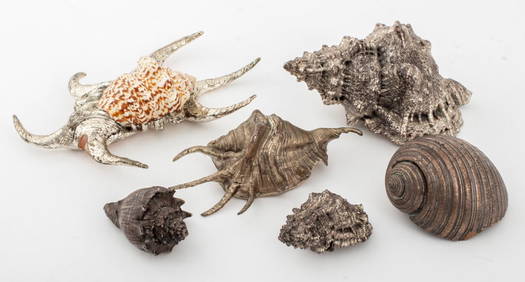
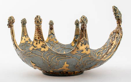
Erte "Ocean II" Patinated Bronze Table Bowl, 1987Auctions at Showplace4.6(740)See Sold PriceApr 07, 2024
CHART: South Pacific Ocean / SOCIETY ISLANDS - WESTERN GROUP/ HUAHINE TO MAUPITI With theChurchill Galleries3.7(217)See Sold PriceFeb 26, 2024
BOOK HISTORY OF THE JEWS IN RUSSIA VOLUME 1 1914.Antique Arena Inc.4.5(878)See Sold PriceJun 15, 2024